

-
 15634 Hits
-
 81.18% Score
-
 13 Votes
|
|
Mountain/Rock |
|---|---|
|
|
32.73968°N / 16.94004°W |
|
|
Hiking, Scrambling |
|
|
Spring, Summer, Fall, Winter |
|
|
5908 ft / 1801 m |
|
|
Overview
 The moon rising between Pico Cidrão and Pico do Arieiro The moon rising between Pico Cidrão and Pico do Arieiro |
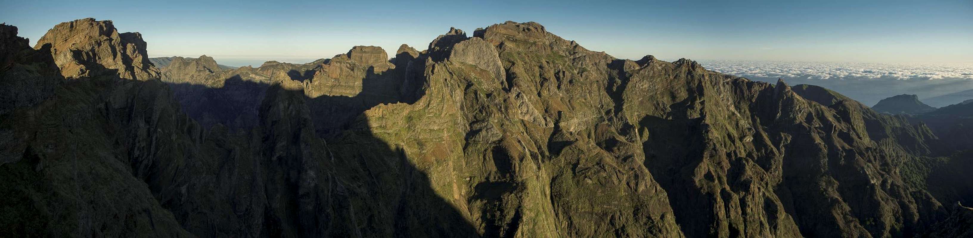
The island of Madeira is located in the Atlantic ocean about 450 km northwest of the Canary Islands. It has been created by volcanic eruptions but in contrast to the Canarias erosion has formed the island by creating bizzare rock formations as well as deep gorges. Madeira is "the vertical island" because wherever you go somewhere's a vertical drop of several hundred just beside you. This is particularly evident in Madeira's central mountain range and the route between Pico do Arieiro and Pico Ruivo.
 |  |  |
Along this route you will find Madeira's highest mountains, among them Pico do Cidrao. It is located west of Pico do Arieiro and can be reached in less than an hour from the parking lot on Madeira's third highest mountain. While the ascent is not really difficult, except for a short UIAA II+ section near the top, it is very steep and exposed. Much of the ascent follows rough steps, which were cut into the soft rock of the mountain.
 |  |  |
Thanks to the hidden start of the acent route only few people ever try to climb it. Most of the visitors would be deterred by the steepness, even though Pico do Cidrao is one of the most prominent peaks of the island. From Pico do Arieiro it looks like a tabletop mountain with impressive faces on all sides. It takes centre stage among all mountains of the central range.
Route
The shortest access to Pico do Cidrao starts at MAdeira's third highest summit Pico do Arieiro. Follow the traverse to Pico Ruivo until you reach the base of Pico do Cidrão. Here the Pico Ruivo trail turns right through the Pico do Cidrão north face, decending on a rugged staircase. Here (coordinates N32 44.398, W16 56.317) the summit trail turns off to the left. Trade wind clouds sweep across Pico do Cidrão Trade wind clouds sweep across Pico do Cidrão | [img:598860:alignleft:small:] | [img:71148:alignleft:small:] |
It follows rough stairs, cut out of the soft rock, then turns into a narrow path. A big rock is passed to the right before you have to turn left and climb a short chimney. Above the chimney more stairs lead up to a ledge, which heads up onto the summit ridge. After a few steps you'll reach the crux, a short exposed 4m UIAA II+ scramble, which leads you to the summit plateau.
The whole route takes less than 1h from Pico do Arieiro.
Getting There
  |
Madeira can be reached from any of the major European airports. There are almost no regular flights (with the exception of some portugese airports) but quite a lot of charter flights. Pico do Cidrao is located right next to Pico do Arieiro, Madeira's third highest mountain, which can be reached by car.
- From the airport take ER207 to Santo da Serra, switch to ER102, direction Camacha and at Quatro Estradas switch to ER202 to Pico do Arieiro.
- From Funchal take ER103 through Monte to Ribeiro Frio. At Poiso switch to ER202 to Pico do Arieiro.
Red Tape
There is no red tape. Parking lots are free of charge. However, take extreme care with fire. There has been a series of forest fires in the last years which destroyed much of Madeira's wonderful vegetaion, especially on the south side of the weather divide.Accommodation
You can find a lot of hotel rooms and apartments on Madeira. Either visit the next travel office or do an internet search. The island is small, all trailheads can be reached by car in an hour from almost anywhere on the island. Most accomodation can be found in the south of the island near Funchal and Camara de Lobos.Weather Conditions
[img:911670:aligncenter:medium:Trade wind clouds sweep across Pico do Cidrão]Weather conditions cannot be predicted accurately. Madeira is located in the trade wind zone. You almost always encounter northeastern winds which carry a lot of humid air. Being forced to climb to higher altitudes this moisture condenses into clouds. This in return means that most of the time the northern part of the island is covered in clouds from altitudes of 1000m through 2000m.
The mountains themselves - being of the same altitude -finally stop the clouds so that on their southeastern slopes the clouds "run out". Unfortunately all of the major peaks of Madeira lie around the weather divide, sometimes within, sometimes just out of the clouds.
The following table shows weather data for Funchal on the southern coast. Be careful with these data if you want to climb the summits...
| Month | Jan | Feb | Mar | Apr | May | Jun | Jul | Aug | Sep | Oct | Nov | Dec |
| Avg. day temp.[°C / °F] | 16 / 61 | 16 / 61 | 17 / 63 | 20 / 68 | 24 / 75 | 27 / 81 | 29 / 84 | 29 / 84 | 27 / 81 | 23 / 73 | 21 / 70 | 17 / 63 |
| Avg. night temp.[°C / °F] | 9 / 48 | 9 / 48 | 10 / 50 | 12 / 54 | 15 / 59 | 19 / 66 | 21 / 70 | 22 / 72 | 19 / 66 | 16 / 61 | 13 / 55 | 11 / 52 |
| Water temp.[°C / °F] | 16 / 61 | 15 / 59 | 16 / 61 | 16 / 61 | 19 / 66 | 22 / 72 | 24 / 75 | 25 / 77 | 24 / 75 | 23 / 73 | 20 / 68 | 17 / 63 |
| Rainy days | 12 | 7 | 8 | 4 | 2 | 1 | 0 | 0 | 2 | 6 | 6 | 10 |
Maps & Books
Maps
- Madeira
Tour & Trail Map
Discovery Walking Guides
1:40000
ISBN: 190494678X
Books
My recommendation is a guidebook by Rother Verlag, available in several languages. The book is an excellent hiking guide covering all the interesting areas of the island. Since it comes with small maps for each excursion it might even be used without a map to support them.
- Madeira
Rolf Götz
Rother Verlag
ISBN 978-3-7633-4811-4 (English)
ISBN 978-3-7633-4274-7 (German)
ISBN 978-3-7633-4910-4 (French)
ISBN 978-3-7633-4297-6 (Portugese)
ISBN 978-3-7633-4708-7 (Spanish)