
-
 5091 Hits
-
 76.28% Score
-
 7 Votes
|
|
Mountain/Rock |
|---|---|
|
|
32.73949°N / 16.98383°W |
|
|
Download GPX » View Route on Map |
|
|
Hiking, Scrambling |
|
|
Spring, Summer, Fall, Winter |
|
|
5315 ft / 1620 m |
|
|
Overview
 Pico do Cerco in front of Pico Ruivo and Pico das Torres Pico do Cerco in front of Pico Ruivo and Pico das Torres |
The island Madeira can be divided into two parts at Boca da Encumeada, a saddle on the weather divide of the island. To the west is the huge plateau Paul da Serra, in the east the central mountain range with its bizarre mountains which rise to 1800m and above. In between, starting a bit to the east of Boca da Encumeada, is a north to south running ridge of mountains, culmulating in Pico Grande's basalt summit block. It is famous for the best views of (and on) the island but all mountains on the ridge can rival them. If there's one summit to surpass Pico Grande it is its eastern neighbour, Pico do Cerco.
Both mountains have similar elevations and if it weren't for Pico Grande's small summit block they would almost be identical. They are separated by a slightly pronounced saddle, where the ascent routes of the summit separate. From Boca da Corrida both (and more) can be climbed in one day.
 |  |  |  |
Seen from the south, Pico do Cerco does not look like much. A cone with steepish, grass covered slopes culminates in a small summit plateau. Pass around to the east, west or north and you will see a completelly different mountain. Now, the faces drop for several hundred metres into the Curral Cauldron, 1500m above which Pico do Cerco looms or hovers.
 |  |  |
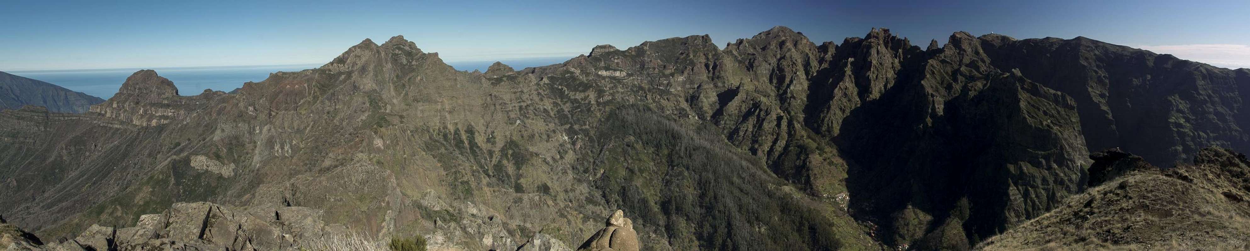
It is this position above the cauldron but almost in its centre, which makes Pico do Cerco such an interesting lookout peak. The whole rim of the cauldron is on display, from the coast in the south-east to Pico da Encumeada in the north-west. The three highest mountains of the island, Pico Ruivo, Pico das Torres and Pico do Arieiro tower right above and across the valley and on a usual day the trade wind clouds spill across the weather divide.
Summit Panorama
  |
Getting There
 Pico do Cerco in front of Pico Ruivo
Madeira can be reached from any of the major European airports. There are almost no regular flights (with the exception of some portugese airports) but quite a lot of charter flights. There are several possible trailheads for Pico do Cerco and Pico Grande, most of which require lengthy hikes to get into the vicinity of the mountains. The shortest route starts at Boca da Corrida.
- Follow motorway ER101 from the airport to the west.
- At the exit Estreito de Câmara de Lobos get off an start headsing up to the village.
- Drive through but remain in the western part of the village (always going up) until you get to Achado.
- Drive through there as well. The road gets steeper and steeper and ends at Boca da Corrida.
Routes
 Pico Grande seen from Pico do Cerco
The shortest route starts at Boca da Corrida and follows the ridge which connects the saddle with Pico Grande and Pico do Cerco. It is straightforward and marked up to Pico Grande, from where an unmarked footpath takes you to the saddle between the two mountains. The final ascent is pathless.
From Boca da Encumeada there is an old Camino to Boca do Cerro and on to Boca da Corrida. It is a longish but you can reach Pico do Cerco from Boca do Cerro in about two hours. Rewarding, but strenuous.
You can also hike the weather divide towards Pico do Jorge and Pico Casado, from where a path heads for Pico Grande. However, a sign "dead end" seems to indicate that part of this route fell victim to landslides.
Last but not least (in terms of elevation gain) you can start at Curral das Freiras and hike another old camino towards Boca do Cerro, from where you'll reach Pico do Cerco in about two hours. This route is straightforward but scales more than 1500m elevation!
Red Tape
No Red Tape here. Rather make sure you hike the path in the right season. Huge gorse bushes can cover the trails and bushwhacking through them can be a painful affair. Recent forest fires (summer 2012) have sestroyed most of the bushes but it is obvious that they will return with a venegance.Accommodation
You can find a lot of hotel rooms and apartments on Madeira. Either visit the next travel office or do an internet search. The island is small, all trailheads can be reached by car in an hour from almost anywhere on the island. Most accomodation can be found in the south of the island near Funchal and Camara de Lobos.Weather Conditions
 Pico do Cerco above Boca das Empenas
Weather conditions cannot be predicted accurately. Madeira is located in the trade wind zone. You almost always encounter northeastern winds which carry a lot of humid air. Being forced to climb to higher altitudes this moisture condenses into clouds. This in return means that most of the time the northern part of the island is covered in clouds from altitudes of 1000m through 2000m.
The mountains themselves - being of the same altitude -finally stop the clouds so that on their southeastern slopes the clouds "run out". Look at the pictures - it looks like the clouds creeping over the weather divide. Boca da Encumeada - being some 500m lower than the surrounding summits - is a gateway for the clouds from north to south. Thus it very often is covered in mist. Unfortunately all of the major peaks of Madeira lie around the weather divide, sometimes within, sometimes just out of the clouds.
The following table shows weather data for Funchal on the southern coast. Be careful with these data if you want to climb the summits...
| Month | Jan | Feb | Mar | Apr | May | Jun | Jul | Aug | Sep | Oct | Nov | Dec |
| Avg. day temp.[°C / °F] | 16 / 61 | 16 / 61 | 17 / 63 | 20 / 68 | 24 / 75 | 27 / 81 | 29 / 84 | 29 / 84 | 27 / 81 | 23 / 73 | 21 / 70 | 17 / 63 |
| Avg. night temp.[°C / °F] | 9 / 48 | 9 / 48 | 10 / 50 | 12 / 54 | 15 / 59 | 19 / 66 | 21 / 70 | 22 / 72 | 19 / 66 | 16 / 61 | 13 / 55 | 11 / 52 |
| Water temp.[°C / °F] | 16 / 61 | 15 / 59 | 16 / 61 | 16 / 61 | 19 / 66 | 22 / 72 | 24 / 75 | 25 / 77 | 24 / 75 | 23 / 73 | 20 / 68 | 17 / 63 |
| Rainy days | 12 | 7 | 8 | 4 | 2 | 1 | 0 | 0 | 2 | 6 | 6 | 10 |
Maps & Books
Maps
- Madeira
Tour & Trail Map
Discovery Walking Guides
1:40000
ISBN: 190494678X
Books
My recommendation is a guidebook by Rother Verlag, available in several languages. The book is an excellent hiking guide covering all the interesting areas of the island. Since it comes with small maps for each excursion it might even be used without a map to support them.
- Madeira
Rolf Götz
Rother Verlag
ISBN 978-3-7633-4811-4 (English)
ISBN 978-3-7633-4274-7 (German)
ISBN 978-3-7633-4910-4 (French)
ISBN 978-3-7633-4297-6 (Portugese)
ISBN 978-3-7633-4708-7 (Spanish)