Overview
![La Terratta and Monte Argatone]() Monte La Terratta and Monte Argatone seen from the east Monte La Terratta and Monte Argatone seen from the east |
. With these words the host of our holiday apartment greeted us when we arrived at his place near
Sulmona in the
Abruzzi Region of Italy. We quickly looked at each other, seeing the answer "Why Not?" in our eyes and agreed. Thus we were into the biggest hike we have ever done and preparation made way for improvisation as we had a GPS track to guide us but the mobile phone it was on had to be turned off foor 90% of the time since its owner had forgotten to charge it the night before...
The two 2000ers in question were
Monte La Terratta (2208m) and
Monte Argatone (2149m) which form a three-summitted ridge west of
Lago di Scanno, more or less straightforward to reach from the villages at their base,
Scanno and
Villalago, but for us and our hosts, the culmination points of a 30km hike which scaled more than 2200m of elevation.
Monte Argatone is the lower and smaller of the mountains, rising in the north of the ridge to
La Terratta. It is a broad backed mountain, which - together with its neighbour - rises 500m above the surrounding hill-like landscape. Its summit lies way above the timber line so that views indeed can be excellent, reaching both coasts of the Adriatic as well as the Thyrenean Seas.
The mountain - or rather its very top as well as its western slopes are part of
Parco nazionale d'Abruzzo, Lazio e Molise, in which construction is restricted. However its east slopes, the ones above
Scanno and
Villalago are used for ski runs. Thanks to its smooth slopes and round top, the mountain can be climbed in any season, with snow shoes or tour skis in winter conditions of course.
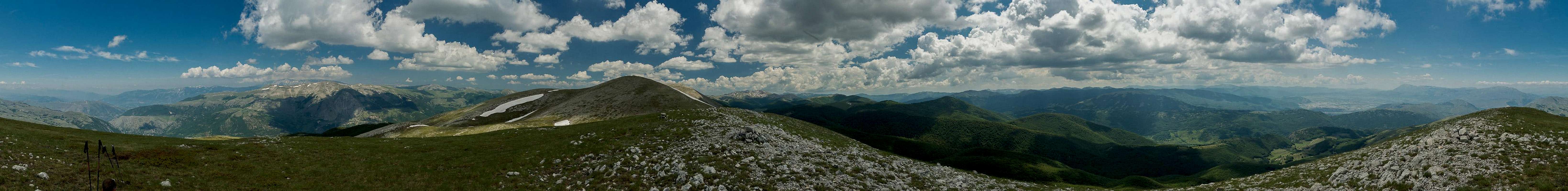
360° Summit Panorama
360° Summit Panorama from Monte Argatone |
Getting There
![Monte Genzana in front of Montagne del Morrone and Majella]() Monte Genzana in front of Montagne del Morrone and Majella
Monte Genzana in front of Montagne del Morrone and Majella
There are two reasonable trailheads for the hike to
Monte Argatone and an utterly unreasonable one. The former are at
Villalago and
Scanno, two neighbouring villages on
SR479 in l'Aquila province, the latter some dozen km to the north at
Cocullo.
- Take motorway E60 until you reach the exit Cocullo.
- For the first two trailheads turn south to Anversa degli Abruzzi and onwards onto SR479 to Villalago or Scanno
- For the third trailhead head north for a few hundred metres to Cocullo.
If you plan to do the traverse
Cocullo to
Scanno across
Monte Argatone and
Monte La Terratta you best park at the railway station at
Sulmona and take the morning train to Cocullo. From the main square at
Scanno a bus goes back to Sulmona station in the evening.
Routes
From Scanno
You leave the village heading to the south for the cableway station of the
Colle Rotondo chair lift. Stay on the road which takes you to
Vallone del Carpale. First you can follow a dirt road but later on, when the trees have made way for pastures you can head up traillessly to the end of the valley. You head for a saddle to the south of
Monte La Terratta. Traverse the summit heading across its secondary north summit, (both above 2200m), then down to a saddle and back up to
Monte Argatone. The ridge traverse is strenuous but easy, thanks to the very broad but somewhat steep ridges).
From Villalago
Head out southwards from the village, then turn to the south-west in the direction of
Rifugio Stazzo Montagna Grande. The route follows a valley to its end, negotiates a step and reaches the Rifugio.Stay on the trail (now in southerly direction) and you'll reach the ridge in the sadlle between
Monte Argatone and the
La Terratta north summit. Turn north-west to reach the summit.
From Cocullo
This route is not really reasonable unless you love long outings with long distances and much elevation gain. In that case 30.7km and 2200m elevation gain might attract you. The "route" is a patchwork of dirt roads, trail-less terrain and narrow paths, often obstructed by low trees and large bushes. For the first 28km it is not really a ridge traverse but once you reach the base of Monte Argatone, you'll follow the ridgline across its summit and both of
Monte La Terratta. It is difficult to describe the route - my suggestion is to load the GPS track onto adevice and follow in our steps. You certainly can do better than that but after all we didn't take too many detours
Red Tape
The summit ridge and the west slopes of the mountain belong to
Parco nazionale d'Abruzzo, Lazio e Molise, a national park. The usual restrictions apply here. Stay on the trails (see routes) and don't try to ascend or desend the west slopes.
When to Climb
Since the mountain poses no difficulties and has very broad ridges which are not avalanche prone, it can be climbed at any time of the year. In winter, the ridge traverse from Cucullo to Scanno is much easier when done with tour skis.
Accommodation
There's ample accommodation'options in the area, however rather hard to find. Google searches often end up at the tripadvisor, casamundo or booking.com portals. There is a thriving community of British expatriates, many of whom offer apartments for rent. Maybe a good starting point is this site
visit-scanno.itWeather Conditions
Maps & Books
Maps
- Digital Maps
- Regular Maps
I haven't been able to find a map for the area around scanno and had to rely on the maps for my GPS, which can be found here
Books
- Abruzzen
Heinrich Bauregger
Rother Verlag
ISBN 978-3-7633-0413-2

 3020 Hits
 79.04% Score
 10 Votes
 Monte La Terratta and Monte Argatone seen from the east


 Monte Genzana in front of Montagne del Morrone and Majella

