
-
 2659 Hits
-
 78.27% Score
-
 9 Votes
|
|
Mountain/Rock |
|---|---|
|
|
46.08728°N / 9.64342°E |
|
|
Download GPX » View Route on Map |
|
|
Hiking, Skiing |
|
|
7713 ft / 2351 m |
|
|
Overview
 On Monte Lago's west ridge On Monte Lago's west ridge |
Monte Lago is an unspectacular mountain on the Valtellina / Veltlin side of the Alpi Orobie. It lies centrally on a ridge which runs northward from the Orobie main ridge, starting at Monte Fioraro and ending with Monte Piscino above Tartano. Though itself a round-topped gras mountain, Monte Lago offers surprisingly beautiful and far reaching views, thanks to the fact that no higher mountains can be found close by.
 |  |  |
The most impressing views are found to the north, just across Valtellina / Veltlin in the glaciated mountains of the Val Massino Alps / Bergeller Alpen. Backside views of Monte Disgrazia, Pizzos Badile and Cengalo attract most attention. Up close the Alpi Orobie dominate the eastern and western skyline while in the far west the long ridges of the Bernese Alps shine above the mist.
 |  |  |
As a hiking destination, Monte Lago, however, is not very poppular. Ascent routes are rather long or cover quite some elevation and the higher summits on the Orobie main ridge can be reached much more easily from Passo San Marco. The area around Monte Lago was used for cattle grazing until quite recently but appears to have been abandoned, judging from the quality of trails and the ruinous sttate of many of the farm buildings. Even the trekking trail Gran Via delle Orobie, which passes to the south of the mountain, cannot be found easily. In fact we missed it and decided to extend our day tour to Monte Lago instead.
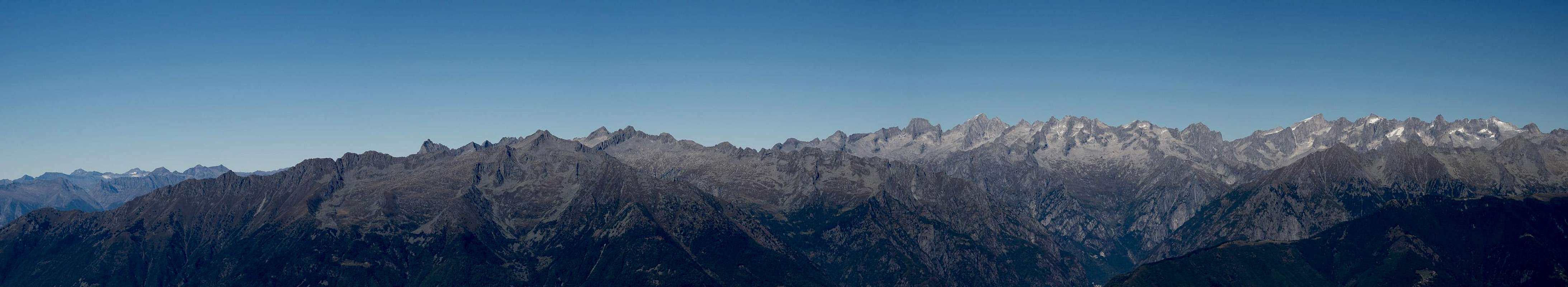
360° Summit Panorama
  |
Getting There
 Western Alpi Orobie above Valtellina
There are several trailheads for Monte Lago, all located on the road from Morbegno to Passo San Marco. The lowest one is at Albaredo (903m), one is at Rifugio Alpe Lago (1510m) and the highest but farthest one at Malga Solivo (1725m).
- From Milano take SS36 passing Monza and Lecco along the eastern shore of Lago di Como
- After Curcio switch to SS38 into Valtellina / Veltlin
- In Morbegno follow the signs for Passo San Marco (SP8)
- The road passes through Albaredo and also passes Rifugio Alpe Lago.
- Before the two final switchbacks there is a farm building (Malga Solivo) to the left side of the road (See "view route on map" for the exact location).
- Alternatively take motorway A4 from Milano to Bergamo
- Switch to SS470 to its end at Piazza Brembana
- Stay on the road (SP1 / SP8) which leads across Passo San Marco.
- Drive down the first two large switchbacks for Malga Solivo or drive on to Rifugio Alpe Lago or Albaredo.
- Valtellina Accommodation
- Morbegno Accommodation
- Digital Maps
- Regular Maps
- Lecco, Val Brembana
Kompass Map WK105
Kompass Verlag
1:500000
ISBN: 978-3-85026-463-1
- Lecco, Val Brembana
- Veltlin
Reto Solèr, Maria Schabel
Rother Verlag
ISBN: 978-3-7633-4373-7
- Comer See
Eugen E. Hüsler
Rother Verlag
ISBN: 978-3-7633-4040-8
Routes
 Eastern Alpi Orobie from Monte Lago
The route from Albaredo follows a dirt road which serves as supply road to Rifugio Alpe Piazza, where the other two routes join. The one from Malga Solivo roughly stays the same height but walks out two large bends of two valleys. It passes some 150m above Rifugio Alpe Lago before traversing to Rifugio Alpe Piazza. From Rifugio Alpe Lago you have to follow a barely visible path northward, which steeply climbs the aforementioned 150m before joining the path from Malga Solivo.
 |  |  |
From Rifugio Alpe Piazza the combined routes run south, passing Bivacco Legui at 2000m. It heads for the west ridge of Monte Lago, which it reaches in a steep scramble. The west ridge is rather easy though also steep. There are no issoes with orientation as the summit cross is plainly visible at the end of the ridge.
 |  |  |
In winter Monte Lago is a good ski tour destination. The Ski route starts halfway between summer trailheads Albaredo and Rifugio Monte Lago, where Valle Piazza intersects the San Marco Road SP8. It passes several farm buildings before joining the summer Albaredo Route west of Rifugio Alpe Piazza.
Red Tape
 Bernina Group seen from Monte Lago
Monte Lago belongs to the Parco delle Orobie Valtellinesi, where the usual natural park restrictions apply. The trails aren't used much anymore in this area so that you'll have to bushwhack through some high undergrowth. There are occasional farm buildings, most of which, however, have been abandoned.
Weather Conditions
 Bernese seen from Monte Lago
Accommodation
 |