Gudy Peak as seen from the slopes of "Every Mountain"
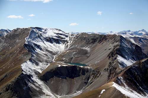
"Gudy Peak" or Unnamed 13566 Peak is located within San Juan Mountain Range and combines nicely with other 13ers along a ridge. I chose to combine it with "C.T. Peak", Unnamed 13540 A and Unnamed 13427. One can even continue further along the ridge up to Wood Mountain, Unnamed 13708 and "Animas Fork Mountain". There is a beautiful lake below the peak - Cooper Lake. Expect solitude on this hike.
Another nice combination hike would be to combine peaks along Cooper Creek Trail and this would include: Cooper Creek Peak, Every Mountain, Gudy Peak and C.T. Peak.
The best way to approach Gudy Peak is either via trail along Cooper Creek or via the ridge hike combining it with other 13ers.
One can start near the Cinnamon Pass - part the scenic alpine loop connecting Silverton and Lake City. This road is a rough 4WD road and very popular with ATVs.
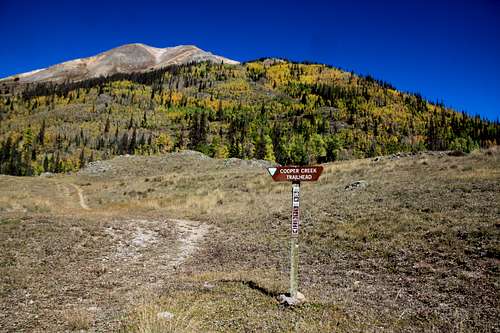
Or you can start hiking Cooper Creek Trail - signed trailhead below Cinnamon Pass.
How to reach Cooper Creek Trailhead: From Lake City, drive south on 149 and take the turnoff the right for Lake Cristobal. Continue south along the lake and follow the scenic alpine road past the Williams Creek and Milld Creek campgrounds to the intersection for Sherman (winter closure past this area). Take the right fork on start an ascent towards Cinnamon Pass. This section of the road is exposed shelf road. After about 3 miles you pass popular trailhead for the Silver Creek/Grizzly Gulch (access for 14ers: Handies, Redcloud and Sunshine). Continue one more mile to a small parking lot and trailhead sign for Cooper Creek.
Route
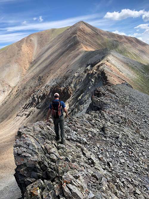
Ridge between C.T. and Gudy Peak
As any mountain there are many options to reach its summit.
I came from C.T. Peak = UN 13312 and ascended the south ridge of Gudy. This section was not technically difficult, but the descent from C.T. Peak was loose, steep and had some 2+ moves. The hike up the south ridge of Gudy Peak was dragging, probably since it was 4th summit of the day and I was a little tired. I descended back the same way to the Gudy - C.T. Peak saddle and then followed the grass slopes down to Cooper Creek where I joined the trail.
Another option to reach the summit of Gudy Peak and also to explore the scenic Cooper Lake, would be to follow the well marked and easy to follow Cooper Creek Trail all the way to the Cooper Lake and then walk around the east side of the lake. The goal would be to reach the east facing ridge, which takes a turn to south.
Red Tape
There is no red tape. Driving the Colorado Scenic Highway, parking and hiking are free.
When to Climb
Summer is obviously the easiest time to climb with a nice access and safety. Winter adds at least 4 more miles each way to approach Cooper Creek TH and danger of avalanches. Always check avalanche conditions prior venturing out during the winter.
Late spring and early fall may offer good opportunity for exploring this peak.
Camping
There are designated campgrounds at Williams Creek and Mill Creek campgrounds. You can find free primitive camping at the trailhead and also at the trailhead at Grizzly Gulch.
Parents refers to a larger category under which an object falls. For example, theAconcagua mountain page has the 'Aconcagua Group' and the 'Seven Summits' asparents and is a parent itself to many routes, photos, and Trip Reports.

 3493 Hits
 79.04% Score
 10 Votes
 Ridge between C.T. and Gudy Peak