
-
 13431 Hits
-
 77.48% Score
-
 8 Votes
|
|
Mountain/Rock |
|---|---|
|
|
37.42950°N / 108.0792°W |
|
|
La Plata |
|
|
Hiking, Mountaineering, Mixed, Scrambling |
|
|
Summer, Fall |
|
|
13180 ft / 4017 m |
|
|
Overview
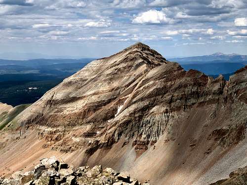
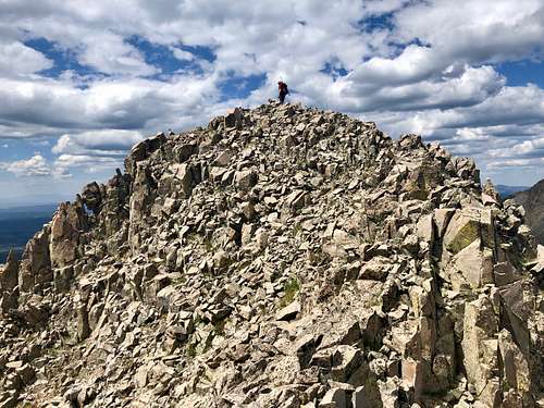 Summit of Babcock Peak
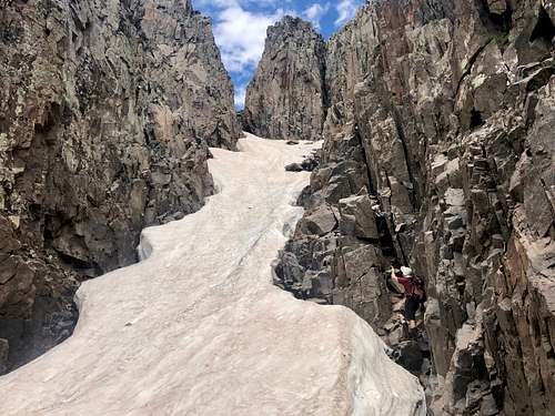 Couloir between Middle and West Babcock - we had no crampons therefore bypassng on rock
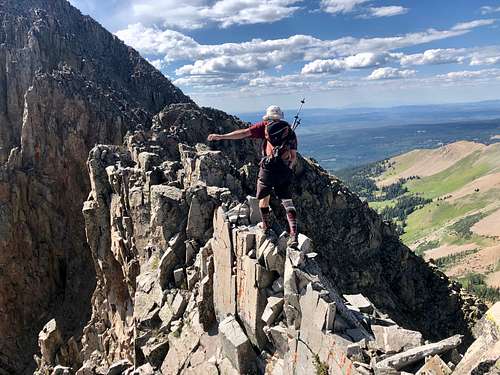 The Knife
Most peak baggers head only for the middle summit and are done with Babcock after reaching this goal. My goal was to reach the highest Middle Babcock, but also to climb West Babcock and explore the infamous Knife Edge towards the Spiller Peak.
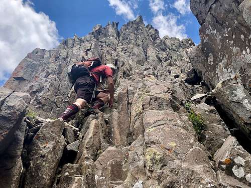 Up Middle Babcock
Guide to the Colorado Mountains with Robert Ormes (sort of a bible of Colorado Mountains) provides only a brief mention:" Multi-summit Babcock Peak (13,149 - note this old guidebook uses the lower elevation and east summit as the main one) forms the southwest fringe of the Tomahawk Basin. When inspected from a distance, it appears that a needle in its western group is higher than the official eastern end. The east summit is best approached from the east ridge. The west group of pinnacles goes best
 Hesperus Mountain as seen from the summit of Babcock Peak
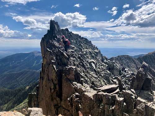 The Knife - ridge between West Babcock and Spiller Peak
Colorado Scrambles Climbs Beyond the Beaten Path with Dave Cooper provides a nice description of The Knife. We mostly followed his recommendations. Dave Cooper wrote in his book that Babcock to Spiller Peak via the Knife is one of the finest traverses in the state. The Knife looks fearsome from any vantage point, but in reality this ridge is quite moderate, although you can expect significant exposure in places. The ridge is the place to be in a thunderstorm, since there are essentially no bailout spots once you commit to it.
Dave Cooper also mentions an error that east point is NOT the high point. The most common approach for Babcock is from Tomahawk Basin. However, for the Knife it makes more sense to use the access via Boren Creek Road.
Colorado Rank: 499
Parent Lineage: Lavender Peak
San Juan National Forest
Range: La Plata: This seldom visited range offers some fine scrambling, and is dominated by Hesperus Mountain, one of the secret peaks for Navajos.
Class: 3+ by its easiest route, we did a little more dificult route
Nearby Peaks:
- Spiller Peak 0.57 miles
- Mt. Moss 0.72 miles
- Lavender Peak 0.93 miles
- Centennial Peak 1.29 miles
- Hesperus Mnt. 1.32 miles
Getting There
Babcock Peak is pretty close to a beautiful and historic town of Durango. Take US 160 west from Durango to the small town of Hesperus. Turn north on La Plata Road for 8.5 miles to its junction with Boren Creek Road. La Plata Road is nice, passable by 2 WD vehicles. Boren Creek Road is steep, rough 4 WD road. I chose to drive only about 1/4 mile and parked on a large pull out on the north side of the road. Boren Creek Road is easier to hike than drive. It is narrow and very rough. It ends up high up in the basin below The Knife - ridge connecting Babcock Peak with Spiller Peak.
Route
 Babcock Peak - the main summit is the middle one.
 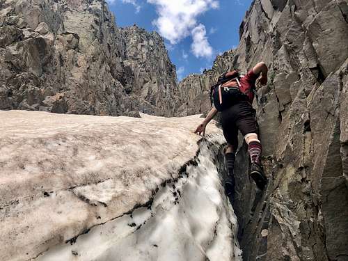 When one is unprepared - we left crampons in the car.
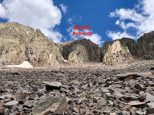
We chose to hike up Boren Creek Rd. I did not want to beat up my car and it was a good choice. The road is rough and narrow. I think we were able to walk faster than we would have been driving. There was a gate higher up - just for the cattle. The road ended up at a basin below the Babcock Peak. There used to be a mine there. We ascended towards the 2nd couloir from the west. I knew from my home research that this couloir leads between West and Middle Babcock Peak. Initially the slopes were grassy, higher up it turned into a talus.
There was still a lot of hard snow inside the couloir, and unfortunately we had no crampons, so we ended up scrambling between the rock and snow. Dave Cooper describes in his Colorado Scrambles to head up the gully and when it starts to take a turn left, to take another gully to the right. Somehow we missed this, but we found some weakness in the wall and were able to ascend and eventually intercept south ridge of the Middle Babcock. There was a lot of scrambling, 4th possibly a few low 5th class moves, but did not feel too hard. It was fun.
The summit has a cairn and a glass register. The views of Hesperus, Lavender and Moss are excellent. We tried to investigate an option to down climb directly into the saddle with West Babcock, initially if went nicely, but then we ran into steep loose rock wall. There was a sling around a rock pinnacle and rappel would be an option, but we had no rope.
We descended the same way as we went up and continued up the main snowy couloir to the notch between Middle and West Babcock. From here, we could see that direct ascent up Middle Babcock is impossible - overhanging loose route. But the way up West Babcock went nicely at class 2 and 3. We rested a little bit on the summit of West Babcock and checked The Knife.
The Knife went easy initially. The route is pretty straightforward. It gets harder halfway through and close to Spiller Peak. I have to say I expected it more of a solid rock, and was surprised by relatively stable stacked up rocks forming it. We tried to stay right on the knife as much as possible. I forgot to time it, but Dave Cooper writes that it takes about 1 hour on traversing The Knife. Scrambling is mostly class 3, there is a lot exposure. When you reach a major notch in the ridge, descend into it it on the right side of the ridge. Down climb the north couloir for about 50 meters (loose terrain) until you gain grassy ledges in a shallow gully on the west side of the notch. Climb up towards Spiller Peak, 3rd class scramble. Avoid the 2nd notch.
Red Tape
Hiking, driving the 4WD Boren Road are free.
When to Climb
Summer and early fall are obviously the easiest time with fast approach on dry land. Winter and spring pose high avalanche risk.
Camping
There are several developed campsites along La Plata Road.
Snowslide Campground: is 6 miles up the canyon from US 160. For information click here.
There is also primitive camping along the road. The land is part of national forest.
External Links
- Babcock on List of John
- Babcock on 13ers.com
- Babcock on Peakbagger
- Babcock on Climb13ers.com
- Middle Babcock from Eartline
- West Babcock and the Knife
- East Babcock from Earthline
- Technical routes on Babcock Peak from Mountain Project