
-
 2206 Hits
-
 79.78% Score
-
 11 Votes
|
|
Mountain/Rock |
|---|---|
|
|
37.76277°N / 107.87038°W |
|
|
Dolores&San Juan |
|
|
Hiking, Mountaineering, Scrambling |
|
|
Summer, Fall |
|
|
13475 ft / 4107 m |
|
|
Overview
 Up V 10 with Vermilion Peak in the background
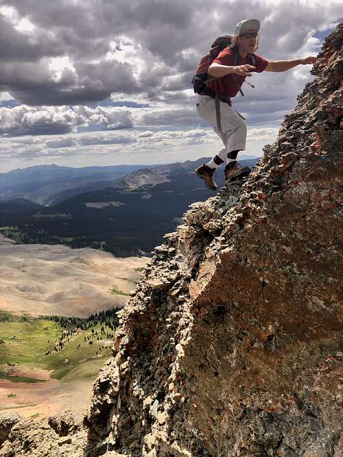 V 10 scramble sections are loose and exposed
V 10 could be combined with Grizzly Peak B. The initial approach is along Colorado trail, but higher up there is a lot of bushwhacking, thick willows and loose gravel.
This peak is seldomly climbed due to its remoteness, loose terrain and class 3 scramble.
Colorado Rank: 271 (not on lists of those seeking centennial and bicentennial summits = highest 100 and 200 peaks in Colorado).
Quad: Ophir
Parent Lineage: Grizzly Peak
Nearby Peaks:
- Grizzly Peak B 0.66 miles
- San Miguel Peak 1.18 miles
- "Lake Point" (unranked) 1.48 miles
- Sheep Mnt B (unranked) 1.78 miles
- V 9 1.80 miles
- Rolling Mountain 2.44 miles
- Unnamed 13300 2.53 miles
- Beattie Peak 3.13 miles
- Vermilion Peak 3.41 miles
- Fuller Peak 3.52 miles
- Golden Horn 3.82 miles
List of V peaks named after Vermilion Peak
| V 1 12,935 | Unranked peak, rarely summited |
| V 2 13,309 | CO rank 387, great hike and views, technically easy class 2 |
| V 3 13,528 | CO rank 238, more challenging at class 2+, loose gravel, great views |
| V 4 13,540 | CO rank 228, loose terrain, class 3, incredible views into Ice Lake Basin |
| V 5 13,156 | CO rank 518, often climbed with South Lookout Peak, class 2+ |
| V 6 12,442 | CO rank 1041, bushwhack to the summit, pretty short. |
| V 7 13,042 | CO rank 612, technically easy, grassy slopes (read a report about a person mountain biking this one). |
| V 8 | don't ask me what happened to this one...some resources use UN 13300 as V 8 (Gerry Roach) and other use West Turkshead Peak. |
| V 9 13,269 | CO rank 435, class 3, nicely located above Hope Lake. Great area to explore. |
| V 10 13,475 | CO rank 271, class 3, willows, very loose terrain. |
Getting There
From Durango drive 28 miles north on US 550 to Purgatory Ski resort. Turn into the ski resort, follow directions for the upper parking lot. At 0.3 miles turn right on Hermosa Park Road, FSR 578. It is signed. At 3.6 miles turn right onto Relay Road, FSR 579. At 4.8 miles go right on Cascade Divide Road - again it is signed. The road becomes more rocky at this point and it does take a long time to reach the trailhead at 15.4 miles. Allow 1.5 hrs from Purgatory.
You need 4WD high clearance vehicle for this one. The views of Engineer Mountain from this road are amazing as you circle around and behind it.
Route
 Cascade Basin - past the waterfall you will turn west into a higher rocky basin
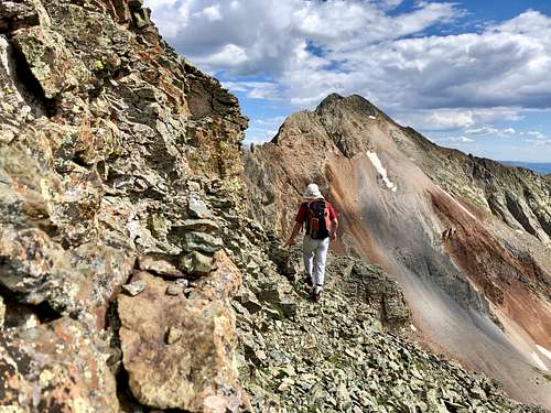 V 10 with Grizzly Peak in the background
The first half of the hike is great. It follows Colorado Trail as it gently goes up and down. Colorado Trail is a popular trail running from Denver to Durango. It is in great shape and this section is often mountain biked. Once you reach Cascade Creek, big turn in the trail and a nice bridge over the creek, you leave the trail and bushwhacking begins. Follow the Cascade creek into a basin above. We went up on the west side of Cascade Creek and ended up torturing ourselves in willows for a long time. We chose to go on the east side of Cascade Creek back and the going was much easier.
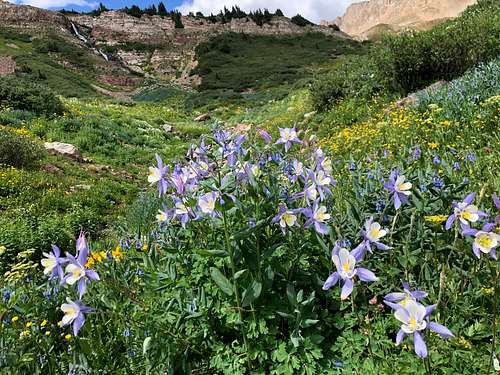
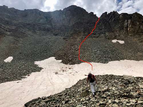
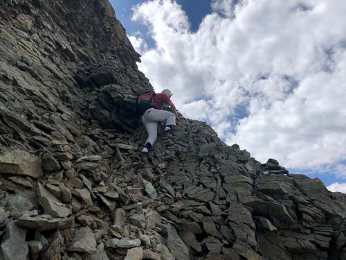
The basin along Cascade creek opens higher up, lots of beautiful wildflowers in the season, waterfall, very scenic and no people. Ascend west past the big waterfall on the west side into another basin, this one is mostly filled with rocks. We were lucky and were able to walk on solid snow fields, which made it easier. Continue to the west basin - V 10 peak is now south of you. Ascend the steep rocky section of V 10, watch out for rock slides, head for the weakness on the ridge. Once on the ridge walk west to the main summit of V 10. The ridge section is fun, loose and exposed. Be careful here. To reach the ridge was annoying due to looseness of the scree.
I charted on Gaia my appropriate route and erased my true recording, therefore it looks different. I roughly followed the drawing below. Again, to AVOID the worst willows, go on the east side of Cascade Creek.
 V 10 gaining the ridge
Red Tape
There is no charge for driving to the trailhead, camping, or hiking. Peak is located in San Juan National Forest (no wilderness rules apply, but keep the area clean and pristine).
When to Climb
 V 10 gaining the ridge
 V 10 traverse on loose terrain
Camping
There is great camping along the Cascade road when you drive in - these are primitive campsites and no fees. I have camped at the end of the road. There are many backpacking opportunities along Colorado Trail.