|
|
Mountain/Rock |
|---|---|
|
|
39.12860°N / 106.4824°W |
|
|
Hiking, Mountaineering, Skiing |
|
|
Spring, Summer, Fall, Winter |
|
|
13942 ft / 4250 m |
|
|
Overview
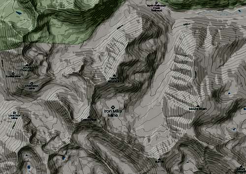
One of the higher peaks in the Pike/San Isabel National Forest and located less than a mile from the Mount Massive Wilderness is French Mountain. Historically known as French Peak, this sublime mountain lies tucked away at the northern end of a stubby ridge that also includes: Casco Peak, Point 13,645' and "Lackwanna Peak."
French Mountain is Colorado's 64th highest peak (adjusted for the new LIDAR measurements) and is one of only two ranked peaks in the Mount Massive quadrangle. While this mountain is only a simple class-2 hike, without a capable, higher-clearance vehicle, the milesge (roundtrip) will be in the ballpark of ~10 miles; not out of the question for a good day, but much of that will be walking on a road. While on French Mountain, expect the usual talus/scree mixed with tundra. There is a social trail on the ridge.
During the middle half of the 19th century, towns and encampments like: Granite, Leadville, Winfield, Oro City, Columbia City etc. (Arkansas River Valley) were hotbeds for migrants seeking employment and their spoil of riches in the mines. People from France, Germany & Austria, among other countries, tried their hand in local mines like the: Swiss Boy Mine, Fortune Mine, Crescent Mining Camp, Clohesy Lake, Iron Mike and pretty much all of California Gulch (now an EPA Superfund SIte). Though its true origin is probably lost to time, French Mountain probably got its name from the many early French prospectors who dug up the hills around North and South Halfmoon Creeks during the 1860's-1870's. In fact, the Arkasas River received its name by French Father, Jacques Marquette, who called the river Akansa in his journal of 1673. So it's plausible early Frenchman bestowed the mountain with its generic name.
Somehow, French Mountain escaped most mining claims and diggings. It is sandwiched in between three mining districts, two being fairly developed; those being: Twin Lakes Mining District, Mt. Champion Mining District (for the time, very profitable) and the Halfmoon Mining District just east downvalley.
French Mountain is located in Lake County (Leadville being the largest city and starting point) named so for the Twin Lakes southwest of Leadville and lies on the top-100 highest peaks list of Colorado. It carries 1,079' of prominance.

Getting There
")
The closest town and jumping off point for French Mountain is Leadville. From the small mountain town of Leadville, travel south on hwy. 24 for 4.1 miles to a Travel stop/gas station and county road #300. Turn right onto #300 and drive for 3/4 mile to a 'T' intersection with county road #11. There will be a sign for Halfmoon Campground. Turn left and drive for 1.3 miles (south) to the intersection with county road #11A. #11A is also known as Halfmoon Creek Road.
Drive west for 5.3 miles to the Mt. Massive Trailhead (an easy 2wd dirt road). This will be on the right. Past this, the road become significantly rougher and 4wd is HIGHLY recommended. There are two options for you at this point:
1.) Reach North Halfmoon Creek TH at mile 7.4 and park here. The North Ridge is directly south as an ascent route or one can walk forest service road to the Iron Mike Mine and ascend that way from the south.
2.) This option doesn't go all the way to the N. Halfmoon TH. Instead, at mile 7.1, turn left (south) and follow forest service road #110J into South Halfmoon Creek Drainage to the Iron Mike Mine. Drive as far as your vehicle can go. This road will end at the mine at 12,660'.
Red Tape
As stated, French Mountain lies in the Pike/San Isabel National Forest. Forest regulations are considerably more relaxed than wilderness. But in general, here are a few guidelines and rules for visits to national forests:
![]()
- Maximum stay of 14 days
- Follow current campfire restrictions
- No fireworks
- FIrearms (certain restrictions apply).
- Pets must be on a leash in developed areas
- Of course, leave no trace and pack out all trash.
Mountain Conditions / When To Climb
French Mountain is an alpine environment. So expect wild temperature swings, possible snow in any month and intense UV. Dress and plan accordingly. This is an easy mountain to hike in summer from most directions. But course, emergencies can happen. Expect an easy day but plan for contigencies. French Mountain does make for a great BC ski trip. Be avalanche aware.
Camping

Dispersed Camping: The closest camping to French Mountain is along Halfmoon Creek Road. After you turn right (west) on Halfmoon Road, take note of a National Forest Boundary sign. Past this, there is FREE dispersed camping for the next 4-5 miles along the creek. Most spots already have rock rings for fires and are rather close to the road. So vehicle noise and dust can be a bit of a problem but at least you have a degree of privacy that campgrounds don't offer.
Halfmoon Creek Campground: This is a popular campground because it is next to Mount Elbert and Mount Massive Trailheads. It sits at 10,000 feet and has first come, first serve sites only. Sites contain picnic tables, fire rings and guests have access to vault toilets and potable water. The costs involved are $20.00 per night and simple day passes here are $7.00. The NFS has been raising rates among campgrounds hence, the higher nightly rate. But with higher useage and trash that people leave, it's not really surprising. The elevation is 9,915' (3.302m).
Elbert Creek Campground: Located off the Halfmoon Road (FSR 110), Elbert Creek is a first-come, first-served campground, with 17 sites, adjacent to the Mt. Elbert and Mt. Massive Trailheads at 10,000'. This is a very popular campground for hikers. Facilities include picnic tables, fire rings, and vault toilets. There is no water. Available is: tent camping, room for trailers, picnic tables and vault toilets. $22 nightly fee per site for overnight camping which includes two vehicles. A third vehicle is an additional $8 per night. Medium to heavy useage.
Mining

* After reading through countless books and some websites, I've found it difficult to come up with any mining history in Lake County, Colorado that doesn't involve the town of Leadville or California Gulch (east of Leadville). Lake County has numerous mines and mills and a long history that at its' origins, mingles with the Native Americans Ute. Through 1959, Lake County mines and mills produced roughly ~2,983,000 ounces of gold with notable amounts of silver, lead, copper and molybdenum. But here's a small sampling of what I've been able to find.
Iron Mike Mine: Located 1.1 miles (1.8 km) south/185°, the Iron Mike Mine is on a patented mining claim know as the Susquehanna Claim. It dates from around 1904 and is shown on the USGS Topographical maps of the area. The 4WD road was built as a supply road for the mine connecting it to the Halfmoon Creek road that went between the Champion Mill and Leadville. Nothing is left but old foundations, typical wood/metal ruins and a collapsed verticle shaft.
Champion Mill & Mine: Mt. Champion Quadrangle, Halfmoon Drainage, Twin Lake Mining District. Most of the ore pulled from this mine consisted of gold, silver, galena, pyrite & Lead. The Champion Mine property was discovered in 1881, but was not developed until 1907 when the Mount Champion Mining Company purchased the property and started construction of a 50-ton per day mill and a 6,100 ft. long tramline. Significant production started in 1912 and continued until 1918. The Champion Mine was dormant from 1919 to 1936 because the cost of shipping ore to Leadville Smelters proved to be unprofitable. The recorded production from the Champion Mine during 1912-1940 was 27,032 oz gold, 12,731 oz silver, 30,690 lb copper, and 97,839 lb lead; there are no records of production after 1940.
The road from the Champion Mill to the Champion Mine, which is snow covered most of the year, had been graded in the mid 1980's. The Champion Mine and Mill are examples of Colorado mining history and it has been placed on the National Historic Register. Coords: 39.12556,-106.51861
Halfmoon Mining District: Being on the small side, this district held 16 claims on 8 mines. There were a total of 330.6 acres of producable mining area. The Halfmoon Creek Basin drained about 61 sq. km to the Arkansas. Many mines are still active as of 2022.
Unknown Maganese Occurance: 1.8 miles (3 km) NNW/348° of French Mountain. Exploratory diggings.
Eureka Mine/Tunnel: Sister mine of the Mt. CHampion Mine located at 12,799' (3.901m). Ore consisted mostly of Maganese with some lead. The Eureka is no longer privately owned. It has been transferred into the hands of the National Forest Service.
Unknown Zinc-Lead-Silver Occurance: 1.9 miles (3.1 km) NNE/5° of French Mountain. Exploratory diggings.
Unknown Gold Occurance: 2 miles (3.3 km) NW/315° of French Mountain. Single occurance on upper Halfmoon Creek.

Some Mining Terminology
1.) Assay- A chemical test performed on an ore sample to determine its mineral composition.
2.) Brownfield Exploration- Ore exploration work that's done close to or at an exiting mine.
3.) Deposit- Any amount of ore or mineral that makes exploration worthwhile.
4.) Free Milling- Ores (usually silver or gold) from which precious metals can be recoverd by concentrating methods without resorting to leaching or chemical treatment.
5.) Lode- A mineral deposit contained in solid rock.
6.) Occurance- A concentration of minerals (usually gold, silver or copper) that is considered valuable or of scientific/technical importance including the formaion of in the environment.
Various Trip Reports
A GONZO report of all the area 13ers via Justiner (14ers.com)
A winter trip report from Mike Silvestro
Peakbagger route track from Ben Brownlee (RIP)
Matt Lemke's report for French Mountain
Alex Henes' report for the French Mountain/Casco Loop
Otina's report on 14ers.com
Topographic Map