
|
|
Mountain/Rock |
|---|---|
|
|
39.95980°N / 105.6811°W |
|
|
12385 ft / 3775 m |
|
|
Overview
Skyscraper Peak is an interesting peak in the Indian Peaks Wilderness and is located south of Devils Thumb Pass and north of Rollins Pass. The peak is not named on the topo maps, but has been known as Skyscraper Peak for decades.
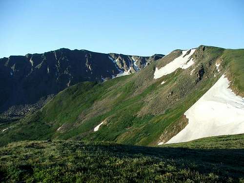
The peak offers something for everyone. There is a class 2 route on the west ridge. There are several snow routes as well. The Challenger Glacier is to the north of the peak and the Skyscraper Glacier is on the south side of the peak. Both glaciers appear to be more perpetual snowfields than true glaciers, but they look fun to climb. There are some small bergschrunds at the head of the glaciers, but no real crevasses. The peak can be seen from Rollins Pass, and has a very high reward-per-effort of climbing.
 Skyscraper Peak. Photo was taken around sunrise. This is looking south.
Getting There
There are three commonly used trailheads for climbing Skyscraper Peak. Since I have only been to two, and hiked to Devils Thumb Pass from these two trailheads, check the link below for the Hessie Trailhead. Front Range residents may want to come from the Hessie Trailhead and Devils Thumb Lake since it offers the shortest driving route from Denver and the rest of the Front Range.
HESSIE TRAILHEAD
You can also drive to the area of east of Rollins Pass from Eldora and hike to Rollins Pass from the Moffat Tunnel, but I am unfamiliar with that driving route as well.
ROLLINS PASS TRAILHEAD
Drive Highway 40, either north of Fraser, or south of Berthoud Pass, to just north of the main Winter Park Ski resort. Between mile markers 231 and 232, turn east on to the road marked for Corona/Rollins Pass (14 miles from Highway 40). This is County Road 80. Follow the main road to the trailhead at Rollins Pass. The road becomes Forest Road 149 after reaching the forest boundary. The road is rough in places, but cars can make it all the way to the trailhead when driven slowly and with great care.
Update: As of 2023 the road is in quite rough condition. One Honda Accord miraculously made it to Rollins Pass when I was there, but I'd recommend at least a Subaru-type vehicle.
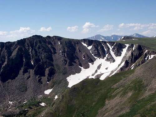
 Skyscraper Peak from near Rollins Pass. 7-23-05.
DEVILS THUMB PARK/CABIN CREEK TRAILHEAD
Drive to the north end of Fraser on Highway 40, and to between mile markers 226 and 227. Turn east on to the road marked for County Road 8. Follow County Road 8 for 6.4 miles to the forest service boundary, at which point the road becomes Forest Road 128. Turn left and follow the road for 1.1 miles to a junction at which point you will turn right and drive for .3 miles to the end of the road and at a small dam. This is the trailhead. This road is also rough in places, but can be driven by a car if you go slowly and if care is taken.
 Skyscraper Peak as viewed from the north and Devils Thumb.
Routes Overview
We summited the peak on the way back from Devils Thumb and Devils Thumb Pass from Rollins Pass, so those are the routes that will be discussed. There are several other more challenging routes available, and many are described in the book Colorado’s Indian Peaks-Classic Hikes and Climbs by Gerry Roach. Here are brief overviews of the routes
The Rollins Pass and West Ridge Route offers the easiest route to the summit. The route follows the Continental Divide north from Rollins Pass and ascends the west ridge of the peak. The route is class 2 and the round trip distance is only 5.6 miles and with about 900 feet total elevation gain.
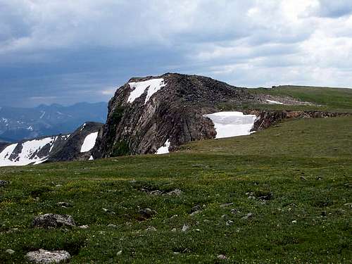 The ridge/subpeak just west of Skyscraper.
The Devils Thumb Park Route is much longer than the one from Rollins Pass, but offers the advantages of a few campsites along the way, and is less exposed to the elements. The route climbs to Devils Thumb Pass from Devils Thumb Park and then follows the Continental Divide south to the west ridge of the peak. The route is class 2 and the round trip distance is 10.2 miles and with about 2800 feet total elevation gain.
 Skyscraper Peak (left) from near the Devil's Thumb. 7-23-05.
Since I am not familiar with any of the routes below, please consult the guidebook mentioned above.
The most interesting routes up Skyscraper Peak appear to be from the glaciers. Challenger Glacier is north of the peak and is approached from Devils Thumb Lake. Skyscraper Glacier is south of the peak and can be approached from Rollins Pass and Betty and Bobs Lakes, or from the Hessie Trailhead.
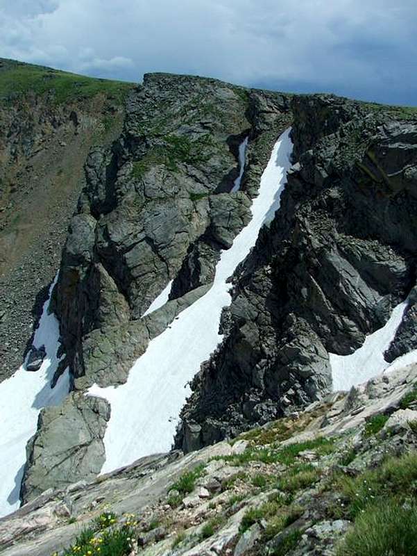 Couloirs on Skyscraper Peak's North side. 7-23-05.
The east ridge of Skyscraper Peak can be climbed by heading north from Skyscraper Reservoir and then west along the ridge and to the summit. The route is rated class 3.
Red Tape
There are no permits required for day hiking/climbing. A permit is required for camping within the Indian Peaks Wilderness between June 1 and Sept. 15. Permits are $5.00 and are available at the locations below:
Sulphur Ranger District
9 Ten Mile Drive
Granby, CO 80446
970-887-4100
Boulder Ranger District
2995 Baseline Road, Room 110
Boulder, CO 80303
303-444-6600
Estes Park Office
161 Second Street
Estes Park, CO 80517
970-586-3440
When To Climb
The normal hiking climbing season is July through September. In winter, it would likely take three days to climb Skyscraper Peak from any of the routes since the roads are not open out of season. There would be high avalanche danger on the glacier routes, but not much danger from Rollins Pass.
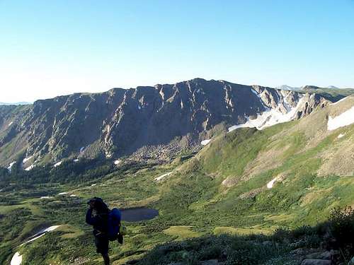
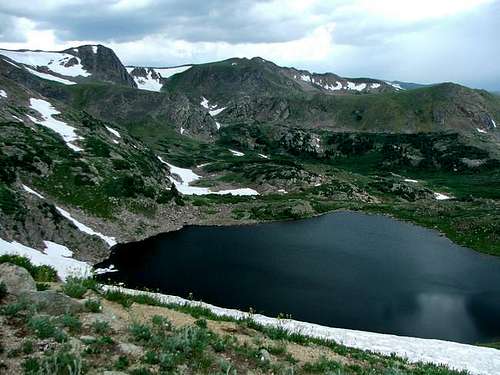
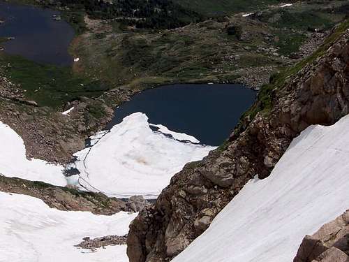 Bobs Lake lies directly below Skyscraper Peak. The water is actually pretty warm if you want to go for a swim. July 23, 2005.
Camping
There are many campsites along the roads to the Rollins Pass and Devils Park/Cabin Creek Trailheads. Rollins Pass itself can be used as a campsite, but it can be windy and exposed to the elements.
There aren’t that many great backcountry campsites along the two routes described to Devils Thumb Pass. If you have a strong tent, there are some flat places along the trail between Rollins Pass and Devils Thumb Pass, but they are all near the ridge and above timberline. There are some campsites not far from the Devils Thumb Park trailhead and along that trail as well as some small campsites higher up and in the forest below the pass. Devils Thumb is usually done as a long day climb rather than an overnighter.
Mountain Conditions
For current trail and snow conditions, more information, and access issues contact:
Sulphur Ranger District
9 Ten Mile Drive
Granby, CO 80446
970-887-4100
SKYSCRAPER PEAK AREA MOUNTAIN WEATHER FORECAST
Below is the climate summary for nearby Berthoud Pass at 11,315 feet elevation. These are all averages, so expect more variation, but this will give you a good idea about the climate at higher elevations in the area. *National Weather Service Data 1950-1985.
| MONTH | HIGH | LOW | SNOW DEPTH | DAYS W/PRECIP |
| JAN | 21 | 1 | 42" | 19 |
| FEB | 24 | 2 | 52" | 16 |
| MAR | 29 | 6 | 63" | 20 |
| APR | 36 | 14 | 67" | 17 |
| MAY | 45 | 23 | 53" | 16 |
| JUN | 54 | 32 | 17" | 11 |
| JUL | 62 | 39 | 0 | 14 |
| AUG | 60 | 38 | 0 | 14 |
| SEP | 53 | 31 | 0 | 11 |
| OCT | 42 | 21 | 3" | 10 |
| NOV | 30 | 10 | 14" | 15 |
| DEC | 23 | 3 | 29" | 18 |