
|
|
Mountain/Rock |
|---|---|
|
|
49.69029°N / 19.01416°E |
|
|
Hiking, Skiing |
|
|
Spring, Summer, Fall, Winter |
|
|
4124 ft / 1257 m |
|
|
Intro
Lack of photos! If you have any, please add. I attached some photos from Beskydy/Beskidy page, but need some more.If you have any information which is missing, please let me know.
Thanks a lot.
Skrzyczne- the highest and most impressive peak in Polish part of Silesian Beskidy(Beskid Śląski/Slezske Beskydy).
It is considered as the wildest, the steepest and the most beautiful peak in Silesian Beskid. Almost fully covered by forests. On the top of Skrzyczne there is a meadow- that makes Skrzyczne a fantastic viewpoint:
- east: Kotlina Żywiecka Basin with Beskid Mały/ Small Beskid
- south-east: almost whole Beskid Żywiecki (Beskid Wysoki)/ High Beskid with beautiful silhouettes of Babia Góra (1725 m) and Pilsko (1557 m)- two highest peaks of Beskidy.
- south/south east: the ridge of Tatras
- south: Barania Góra (1220 m) and further: Mala Fatra
- west: Czantoria Massif/ Cantoryje Massif
- north west: Klimczok (1119 m) Massif with Magura (1095 m) and Trzy Kopce (1084 m).
 Beskid Mały seen from Skrzyczne.
Skrzyczne- 1257 m
Located in a north- eastern part of Pasmo Wiślańskie/Barania Góra Massif . It’s on the northern end of long ridge of Barania Góra- slightly lower (1220 m) than Skrzyczne itself but considered as the main peak of the whole massif. Skrzyczne- 1257m and Male Skrzyczne- 1201m
In the south- west/main rigde of Skrzyczne are two subsummits of Skrzyczne: Małe Skrzyczne/Small Skrzyczne- the lower summit (1201 m) and Kopa Skrzyczeńska- 1180 m- a small bump in the ridge.
South- east ridge is short and has one small summit called Równia (850 m).
The slope between those ridges falls to Dolina Malinowskiego Potoku/ Malinowski Stream Valley.
To the north there is also a short ridge which ends in a summit of Skalite (864 m).
Eastern slopes of Skrzyczne are steep and wild- rises over 700 meters above Kotlina Żywiecka Basin.
North- western slopes are gentler, falls to Żylica Valley where the city of Szczyrk is located.
On the summit of Skrzyczne there are severeal buildings: the upper stations of ski lift and chair lift from Szczyrk, Radio-TV tower and mountain chalet owned by PTTK (Polskie Towarzystwo Turystyczno Krajoznawcze).
 |
 |
 |
Caves
The largest amount of caves in Silesian Beskid are located in Skrzyczne Massif. Most of them were dicovered by speleogists in 1969 and 1970.The first one, called Jaskinia Pajęcza/ Spiders Cave is 40 meters long. It’s on the north slope, not far away from the ski piste.
Second cave is located 200 meters above Hala Jaworzyna- the mid station of chair lift. It’s called Jaskinia w Skrzycznem I/ Cave in Skrzyczne I. Not far away are two another caves: Jaskinia in Skrzyczne II and Jaskinia in Skrzyczne III.
Near the north ridge, which leads to Skalite there are Jaskinia in Skrzyczne IV and Jaskinia in Skrzyczne V.
Skiing
Skrzyczne is famous for its ski slopes.Szczyrk is a biggest ski resort in whole polish part of Beskidy Mountains. There are many ski trails on Skrzyczne, Male Skrzyczne and other nearby mountains.
It’s divided into two centers: Skrzyczne itself and Małe Skrzyczne- Czyrna.
 Male Skrzyczne from Skrzyczne.
Male Skrzyczne- Czyrna
Biggest ski center in Poland. 13 ski lifts- 7,8 km long and over 22 kilometers of ski trails. Trails are of all difficulty levels (percentage):
Easy:
- green- 39%
- blue- 31%
Medium:
- red- 23%
Hard:
-black- 9%
Two of them: Bieńkula and Golgota have FIS homologation.
Adress:
Szczyrk
Ul. Narciarska 10
Phone: +48 033 817 89 26
Official site (in Polish)
Map of the ski lifts and trails
Skrzyczne
Second biggest ski center in Szczyrk. Chair lift and 3 ski lifts. Chair lift was built in 1958. The first part of the lift is 1628 meters long with 543 meters of height difference, the second one 1250 meters long with 300 meters of height difference.
4 ski trails (14 km). Two easy, one medium and one hard: the only one in Poland which has FIS licence (2800 meters long).
Adress:
43- 370 Szczyrk
Ul. Plażowa 8
Phone: +48 033 81 78 662
E- mail: cos@szczyrk.com.pl
Official site
Map of the ski lifts and trails
Routes overview
It’s possible to climb Skrzyczne from all sides.Marked trails that leads to the summit of Skrzyczne:
1.from Szczyrk by green marks: 2,5 up, 2 h down
2.from Szczyrk by blue marks- through Hala Jaworzyna: 1,5 h up, 1 h down
3.from Barania Góra through Malinowska Skała and Małe Skrzyczne by green marks: in both directions 3,5 h
4.from Zywiec through Lipowa by blue marks: 4,5 h up, 3,5 h down.


Getting there
Nearest airports: Katowice- Pyrzowice or Cracow- Balice.The biggest city near Skrzyczne is Bielsko Biała- 50 kilometers south from Katowice.
From Bielsko Biała drive south to Szczyrk (30 km) or south-east to Zywiec (25 km).
Bielsko Biala and Żywiec are reachable by train- the cheapest mean of transport in Poland:
Polish railways site
Szczyrk is reachable by bus from Bielsko Biała:
Buses from Bielsko Biała
Accomodation/ camping
 Summit of Skrzyczne with Babia Góra in the background.
There are many possibilities for finding a place to sleep in Szczyrk. People offers cheap rooms, there are also few places with rooms of higher standard.
In Szczyrk there is also a camping: Camping PTTK „Skalite”.
Official site of Szczyrk
Rooms are also available in the chalet at the top of Skrzyczne:
Adress:
43- 370 Szczyrk
Phone number:
+48 33 817 85 88
Official site of the chalet (in Polish)
Red tape
There are no red tape.Emergency
Górskie Ochotnicze Pogotowie Ratunkowe- GOPRAdress
Stacja Centralna Grupy Beskidzkiej (all year round):
43-370 Szczyrk,
Ul. Dębowa 2
Phone: (0 33) 829 69 00, (033) 817 89 86
Emergency number: 985
Emergency number in the mountains: +48 601 100 300
GOPR (Beskidy) official site
GOPR (main) official site
When to climb
Skrzyczne is climbable all year round.Weather forecast
Skiing conditions
Webcams (sometimes work, sometimes not...)
Solisko
Hala Skrzyczenska
 Trail from Barania Góra to Skrzyczne.
Essential gear:
Best time for hiking is summer season: June-September.In summer no special equipment is needed.
In winter conditions: casual equipment for hiking in winter. Expect a lot of snow.
Maps
There are many maps avaialble in Polish book-shops.Online map:
Map of Beskidy
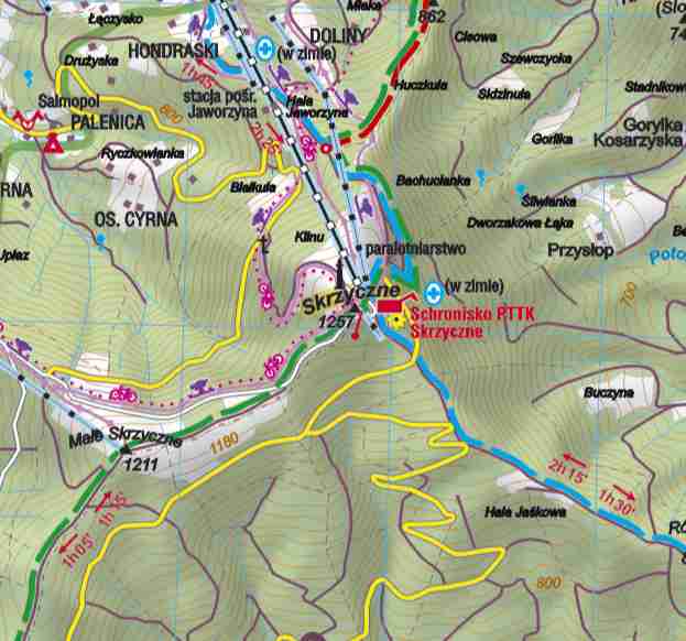
Map of Skrzyczne Area
Links
Because of shortage of photos I put links to the galleries with photos of Skrzyczne:Gallery 1
Gallery 2
Gallery 3
visentin - Aug 19, 2011 5:22 am - Voted 10/10
couple of new picsDuring last week end ! Eric (writting Barania Gora :)
jck - Aug 19, 2011 1:53 pm - Hasn't voted
Re: couple of new picsCool!
visentin - Sep 13, 2012 9:50 am - Voted 10/10
Re: couple of new picsAnd some more, this time on it ;)