
|
|
Mountain/Rock |
|---|---|
|
|
49.54303°N / 20.11129°E |
|
|
Nowotarski |
|
|
Hiking, Skiing |
|
|
Spring, Summer, Fall, Winter |
|
|
4298 ft / 1310 m |
|
|
Turbacz
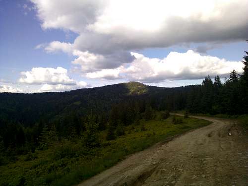
Turbacz from the Bukowina Miejska ridge
Turbacz is the highest mountain in the Gorce range in the Western Beskids in Poland. Due to the myriad of small mountains this range is made up of, the actual summit of
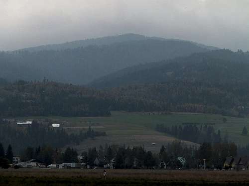
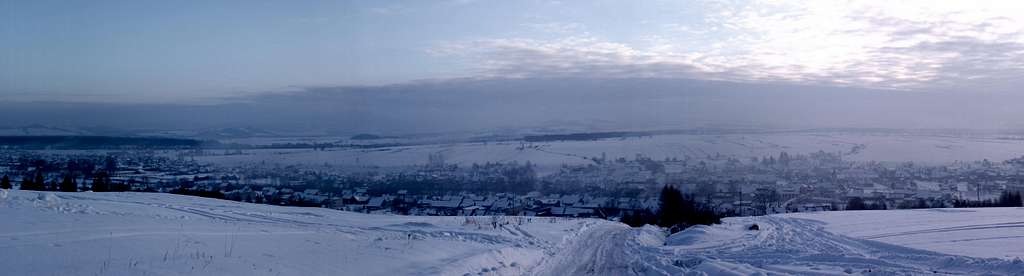
Turbacz from Nowy Targ Airport
As is the case with many popular mountains in the Beskids, also near the summit of Turbacz one can find a mountain hotel offering accommodation, food, warm showers and cold beer. Due to the proximity of the city of Nowy Targ, the area south and west of Turbacz is heavily used as an recreational area, where many people own mountain huts, called bacówki, and the trails are heavily used in this area for hiking, cross-country skiing, biking or riding ATV's, motorcycles or snowmobiles. It's possible to reach the mountain hotel at 1280 metres with a vehicle, preferably a four-wheel drive or a two-wheel drive with high clearance, but this is heavily frowned upon and technically not even allowed if you don't own a bacówka in the area.
Contrary to popular belief, the actual summit of Turbacz is not included in Gorczański Park Narodowy. As a matter of fact, the summit of Turbacz is one the highest summits in the whole of Poland not included in a reserve of any kind.
The north side of the mountain, accessible from Poręba Wielka or Rabka-Zdrój is much calmer, quieter and more suitable for those looking for peace and soltitude. The approach from Niedźwiedź goes through the National Park, the approach from Rabka-Zdrój skirts the National Park.
Getting to Turbacz
From Kraków
Public Transportation

View over Tatry from Osiedle Oleksówki at the north end of Nowy Targ, at the lower reaches of the Gorce range.
Please keep in mind that when arriving to Nowy Targ, the trailheads for Turbacz are on the opposite side of town from where the bus- and train stations are located. To get to the trailheads without having to make a one-hour walk across town, you need to take a city bus. The timetables for that can be found on the website of MZK Nowy Targ
By Car
From the city centre, follow Zakopianka out of town. Past Myślenice this will become the S7 motorway.
In case you're headed to Poręba Wielka, leave the motorway at the first exit in Lubień, and follow road 968 to Mszana Dolna. At the intersection with road 28, turn left, and turn right where road 968 resumes its course to Zabrzeż. After about 1 kilometre, road 968 makes a left curve, and in this curve is the intersection with the road to Niedźwiedź and Poręba Wielka. Follow this road all the way through Niedźwiedź into Poręba Wielka, where you can leave your car for free, or, when in Poręba Wielka, take a left at the Y-intersection, pass through the hamlet of Koninki and leave your vehicle at the very edge of the national park at the (paid) parking lot there.

Magnificent view over Kotlina Nowotarska and Tatry Bielskie from below the summit of Turbacz.
Towards Rabka-Zdrój and Nowy Targ however, stay on the S7 motorway.
Past Lubień, the motorway ends, and the road continues as highway 7, a two-lane highway over the pass at Luboń Mały. Down the pass, you enter the village of Skomielna Biała, and here is where highway 28 and highway 7 meet. The easiest way to the centre of Rabka-Zdrój from here is to take a left onto highway 28 and turn right into the centre at the roundabout. Leave your car somewhere near the railway station in the centre of town.
For Nowy Targ, instead of turning left onto highway 28, you should stay on highway 7 southbound towards Zakopane. After entering Nowy Targ, about a little more than a kilometre past the Orlen petrol station on your right hand side, turn left, and leave the road. Watch out - short and very steep downhill ramp. Turn left, pass underneath the road and turn right at the intersection. At the first roundabout go straight, and at the second roundabout take the road to the left. After about four kilometres, turn right at the church and drive the road to the ski station Długa Polana for the green trail. Here you can park your car. Alternatively, you can drive 200 metres further and take a left at Gazdy, which you should follow to the end. Here is also a place to park your vehicle, and this puts you close to the yellow trail.
Trails
From Poręba Wielka (Koninki, Niedźwiedź)
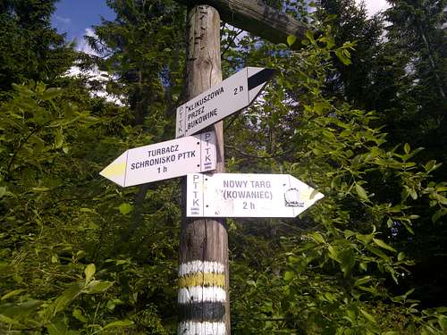
This type of signposting is the standard in the Polish mountains, this particular sign is located at Bukowina Miejska outside of Nowy Targ.
Another option which is less frequented, is the Green Trail from Niedźwiedź, which enters the national park a bit east of the blue trail after going alongside a countryside road for about an hour. This trail is much less frequented, both by day hikers as well as park rangers, which makes it easier to enter the national park for free. The green trail meets the blue trail at Czoło Turbacza (1259 metres). You will gain about one kilometre of elevation in total.
From Rabka-Zdrój
From Rabka-Zdrój there is the Red Trail.
This will be a full day-hike, approximately 4 to 5 hours one-way. Also, the trail gains about a kilometre in elevation from Rabka-Zdrój until Turbacz, while it passes a handful of summits along the way, the first one being Maciejowa (815 metres) - about 15 minutes before reaching the first mountain hut (schronisko) which bears the same name. Another 15 to 20 minutes after the schronisko you will pass Bardo (948 metres) and from this summit the trail follows the edge of the National Park on your left-hand side. The next summit is Jaworzyna Ponicka (995 metres) from where the trail will drop to Przełęcz Posrednie. (920 metres) "Przełęcz Posrednie" means "Half-way Pass" and you're roughly halfway between Rabka-Zdrój and Turbacz there. Here, the trail will start climbing again, and in 10 minutes, at the elevation of about 1000 metres, you'll pass your second schronisko alongside the route, Stare Wierchy. Here is also where the trail starts following the ridge in a more easterly direction, and past Stare Wierchy your next summits along the way will be Groniki (1027 metres), Obidowiec (1106 metres) and Rozdziele (1198 metres). After Rozdziele, the red trail will actually pass over the actual summit of Turbacz (1310 metres) on its way to the Mountain Hotel at 1280 metres. The mountain hotel is where all the other trails come together and where you can enjoy an excellent cold beer.
From Nowy Targ
From the Kowaniec neighbourhood in Nowy Targ there are two options: the Green Trail and the Yellow Trail. Both take about 90 minutes to 2 hours to get to the summit, and both have about 600 to 700 metres of elevation gain.
These two trails are not only the shortest way up to the mountain, but due to their proximity to the city and due to them being fully outside the protected areas, they are also among the most used and least secluded in the entire range. Expect to share the trails during the summer time with mountainbikers, joggers, motorcyclists, ATV-drivers, and partying youth near the many bacówki. During the wintertime, add snowmobilers and cross-country skiers to this list as well.
Both trails start at the bus stop in Kowaniec, the green trail being slightly shorter and steeper than the yellow trail. The green trail follows the road Oleksówki, passes the ski station Długa Polana, and from a bend in this road continues right, across the

Some keep their bacówki simple... (and here's where most partying takes place)

And some don't... This is across the trail from the other bacówki...
From here it's only a short hike to the mountain hotel, and the actual summit of Turbacz alongside the red trail to Rabka-Zdrój.
The yellow trail follows the access road (mostly a dirt track which gets really muddy during spring melt or after rain) to the higher bacówki and the mountain hotel for most of its way up. Only a short section in Kowaniec itself as well as a few shortcuts along the way take a different route. Although there are not as many bacówki along this trail as along the green trail, the yellow trail will be the trail with the most other users on it, especially those entertaining themselves with something containing a combustion engine such as snowmobiles, ATV's or terrain motorcycles (Nowy Targ is home to one of two Arctic Cat dealerships in the whole of Poland)
This is also due to the fact that the yellow trail is in essence for most of it's length mainly a dirt road. Halfway along the way to Turbacz you will pass Bukowina Miejska (1143 metres), from where the trail follows a wooded ridgetop with views over the ridge which Turbacz itself is a part of. Shortly after the aforementioned Papal Chapel (Kaplica Papieska) the yellow trail joins with the green trail to the mountain hotel on Turbacz.
For those who are religiously inclined, at Kaplica Papieska the mass is served once on Saturday evening, and three times on Sunday. More information can be found on the website of the Mountain Hotel.
Kiczora from Polana Swiderowa
Red Tape, Camping and seasonal information.
Red Tape
The amount of red tape is fully dependent on from where you wish to

The vast majority of the unprotected land in Gorce is private property.
Camping
Camping is theoretically allowed outside the National Park, but keep in mind that the vast majority of the land here is private property. There are however, three places where it's possible to spend the night and sleep in a bed - at Maciejowa, Stare Wierchy, and the Mountain Hotel at Turbacz itself. Expect to pay around 40 PLN for a night for a bunk room, or more for singles, doubles and apartments (the latter only available at Turbacz).
Seasonal Information
High Season is May to October, but the mountain is open year round, and so is the PTTK Mountain Hotel at the summit.
During the months of April and early May it can be real muddy at some parts due to snow melt, and this is also the case after a heavy rain. First snow can fall as early as October, but winter usually hits in the end of November. By Christmas, the snow can be up to a metre deep at some parts, and not all trails may be easily accessible from December to early April. However, the yellow trail and the green trail are used so much that these usually stay relatively easy to navigate due to packed snow, maybe except for the first day or two after a major snowstorm.
The village of Waksmund on our way down from Bukowina Waksmundzka, after a winter ascent to Turbacz.
External Links
- Journey planner for hiking trips in the Polish mountains (Polish)
- Weather forecast for Turbacz (1310 meters) (English)
- Weather forecast for Nowy Targ (620 metres) (English)
- Weather forecast for Rabka-Zdrój (480 metres) (English)
- Małopolskie Dworce Autobusowe Buses from Kraków (English)
- Polish Railways (English)
- Timetables for the city buses in Nowy Targ (Polish)
- Gorczański Park Narodowy (Polish)
- Gorce National Park (English)
- Der Gorczański-Nationalpark (German)
- Rules and regulations of the National Park (Polish)
- PTTK Mountain Hotel at Turbacz (Polish)
- PTTK Schronisko at Stare Wierchy (Polish)
- PTTK Bacówka at Maciejowej (Polish)
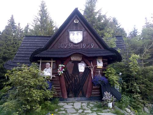
Kaplica Papieska at Turbacz