
-
 32236 Hits
-
 94.44% Score
-
 47 Votes
|
|
Mountain/Rock |
|---|---|
|
|
48.75803°N / 113.65761°W |
|
|
Glacier |
|
|
Hiking, Scrambling |
|
|
Spring, Summer, Fall |
|
|
9376 ft / 2858 m |
|
|
Overview
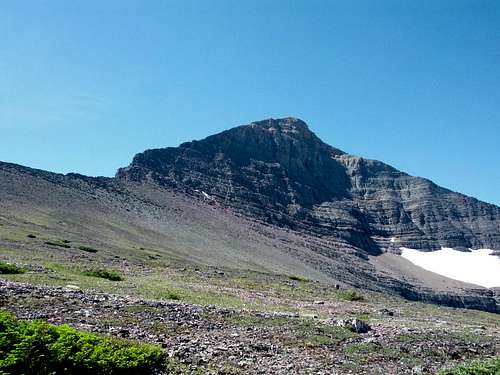
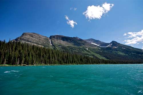
At 9,376 feet, Allen Mountain is the third tallest official summit in the Many Glacier Valley. (Note: Allen is actually the fourth highest peak in the area; Cracker Peak, an unofficial summit, comes in at 9,833 feet). Nearby neighbors Mount Siyeh (10,014) and Mount Gould (9,553) make for a truly impressive cluster of monstrous peaks! It is an immensely large mountain, both in height and bulk, but when one stands on the eastern shore of Swiftcurrent Lake to take in the iconic view, it is easy to lose Allen Mountain amidst its more dramatic neighbors. The unbelievable east face of Mount Wilbur, the impressive spire of Grinnell Point, and the bulky mass of Mount Gould tend to steal the scenery.
Directly to the south of Many Glacier Hotel, a broad, scree-covered mountainside leads uphill towards steep cliffs and a rounded summit. The sub-8000 foot summit is not all that impressive from this vantage point, especially in the company of its neighbors. This is the northernmost peak of Allen Mountain, and it marks the end of a long, jagged ridge that runs south to the actual summit. This peak disguises the enormity of Allen, as much of the mountain, including its towering summit, is obstructed from view. Gordon Edwards, author of A Climber's Guide to Glacier National Park, sums it up best: "Because it is so broad and so close to the road it is difficult to realize how big this mountain is. Climbers who struggle up to its summit, however, will always remember that it is HUGE..." (1). By taking a short stroll to the north shores of Swiftcurrent Lake or nearby Lake Josephine, one can start to appreciate this exceptionally huge hulk of rock.
As one might expect from such a large mountain, there are multiple routes that provide access to the summit. This page will mention several of those routes, and will describe the High Traverse/Great Break Route in detail as in my experience, this is the preferred ascent route for many climbing parties. This route follows a precarious game trail to Snow Moon Basin, one of the more idyllic spots I have had the pleasure of visiting in Glacier Park. Its multiple route options, all requiring the better part of a day, coupled with a commanding summit view and non-existent crowds, make Allen Mountain a mountaineer's delight.
 |
 |
|---|
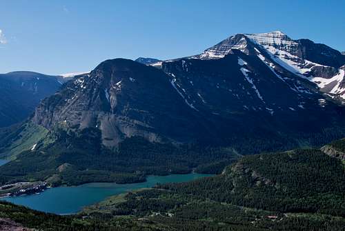
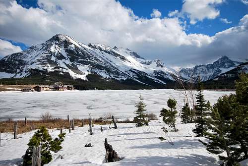
Right: View south from the slopes of Mount Henkel. Left: Allen Mountain behind Many Glacier Hotel & a frozen Swiftcurrent Lake.
Getting There
Allen Mountain is located in the Many Glacier Valley in the northeastern sector of Glacier National Park. immediately south of Many Glacier Hotel, which is accessed from US-89 via the small, unincorporated town of Babb, Montana. A paved, pothole ridden road winds 12 miles from Babb to its terminus one mile past the hotel at the Swiftcurrent Motor Inn. This is the only way to enter Many Glacier via automobile. Babb is located 8 miles north of St. Mary, a small, busy tourist village at the east entrance of the Going-to-the-Sun Road, and 11 miles south of the US-Canadian border crossing at the Port of Piegan in Carway, Alberta.
NOTE: The Many Glacier Road will be undergoing extensive repairs in 2020 and 2021. Access to this area will be greatly impacted and visitors can expect to encounter delays (up to 40 minutes in both directions). Please visit the NPS webpage for some helpful information on planning your visit: Many Glacier Road construction.
Allen Mountain is clearly visible when driving west towards Many Glacier Hotel. It rises across Sherburne Reservoir, and various pullouts along the road afford great views of the face where the Great Break Route makes its steep ascent.Many Glacier can also be accessed via several well-maintained trails. The Highline Trail passes Granite Park Chalet, and detouring east over the Continental Divide on the Swiftcurrent Pass Trail will bring hikers to Many Glacier. The spectacular Piegan Pass Trail, which originates at Siyeh Bend east of Logan Pass on Going-to-the-Sun Road, ends along the shores of Swiftcurrent Lake right next to the Many Glacier Hotel. Hikers coming in from the Belly River Valley can also climb up the steep trail through Ptarmigan Tunnel, which terminates at the Swiftcurrent Motor Inn.
All practical routes for Allen Mountain originate near Many Glacier Hotel. This area has seen a large increase in visitor traffic over the past several years. There is a large parking lot uphill from the hotel; this lot and all nearby parking spaces along the entrance road, at the picnic area near the Grinnell Glacier Trailhead, and at Swiftcurrent Motor Inn are now filling up well before noon during prime tourist season (July through Labor Day). ARRIVE EARLY!!!
Routes
Gordon Edwards' A Climber's Guide to Glacier National Park outlines multiple routes for this grand mountain. Climbing can range from class II all the way up to class IV on the Great Break high above Snow Moon Basin. In my experience, most climbing parties attempt the High Traverse/Great Break Route for at least the ascent portion of Allen Mountain. It is a highly exciting and scenic route, and a true classic in Glacier National Park. It involves an impressive goat trail, a pair of serene alpine lakes, and some solid Class III & IV climbing through a massive cliff band. I will describe this route in detail.
Prominent ridge of Altyn limestone leading away from Many Glacier Hotel
High Traverse/Great Break Route
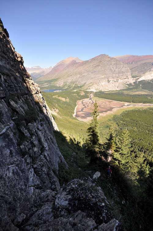
The beginning of this route is referred to as the "High Traverse Route to Snow Moon Basin" by Gordon Edwards. Above Snow Moon Basin, a stiff climb up the Great Break provides access to Allen's summit ridge. Total elevation gain from Many Glacier Hotel is 4,500 feet. It can take parties anywhere from 3 1/2 to 6 hours to reach the summit. Descent time depends on which of the many routes you decide to follow down.Head to the large parking lot above Many Glacier Hotel. If you are unfamiliar with the route, I highly recommend taking a moment to study the terrain directly to the south. Beneath the north summit of Allen Mountain, a large field of loose rock stretches down beneath enormous cliffs to the thick forest below. The rock field is partially bisected by sparse fingers of pine; study the smaller rocky patch on the left, as you will soon be slogging up this stretch towards to the High Traverse Route. A game trail, virtually impossible to see from afar, begins beneath the lumbering cliffs and wraps around Allen Mountain to Snow Moon Basin.
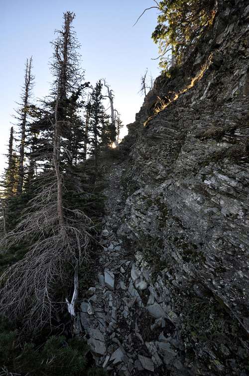
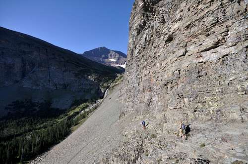
The route begins at the foot of an old wooden horse bridge (still in use today) at the south end of the parking lot, where a very well-worn trail leads directly south along a prominent ridge of Altyn limestone. After a couple of minutes, the trail will dip into the trees and will intersect a maze of animal trails. Try to follow the most well-worn trail, zig-zagging through the forest but always moving uphill and generally to the south. Cairns may help guide you at times; this non-maintained trail is quite regularly traveled, so keep your eyes peeled for signs of human activity. Eventually, the trail will steepen sharply and transition to scree despite staying in the trees. After a short pitch or two, the trail will emerge at the bottom of an enormous talus and scree slope. This rock is very, very loose; pick a game trail for better footing and head straight uphill. Resist the temptation to follow game trails directly east, as this will take you off route and into some precarious climbing. Instead plod upwards towards the massive cliffs, always keeping the smaller cliffy outcroppings to your left. As you head up, better footing will be found in the bottom of a shallow, often dry drainage. Look for a broad ledge that extends to the east just beneath the towering cliffs above; this ledge marks the start of the unmistakable game trail to Snow Moon Basin.
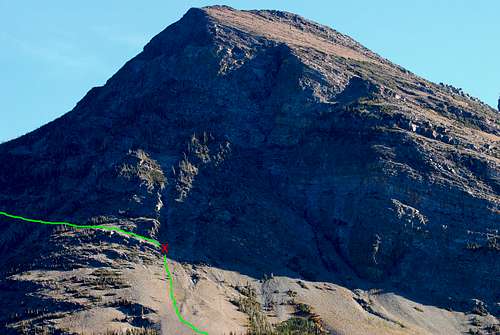 High Traverse Route as viewed from the Many Glacier parking lot. The red "X" denotes the start of the game trail that lead to Snow Moon Basin.
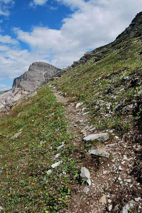
Thanks to all the hiker and critter traffic, the game trail is very easy to follow, although downed timber may slow progress slightly. The trail passes several broad couloirs, one of which requires a bit of attention regardless of the conditions. The game trail narrows here, and is somewhat exposed, so careful footing is imperative. Furthermore, this couloir can often hold snow well into July, and although detours beneath the snow are possible, be forewarned that a slip of any sort here would be less than ideal. The couloir is steep, and a few hundred feet below the game trail is a huge cliff that drops toward Sherburne Reservoir and the Cracker Lake Trail far below. Note: Gordon Edwards describes a detour farther west and downhill if this couloir is choked with snow; see his guide for more information. After safely negotiating the couloir, in only a few minutes you will cross a broad, open shoulder and be greeted to a great view of Wynn Mountain. The game trail veers south and heads downhill for a short stretch before leveling off underneath sheer, crumbly cliffs. Soon after, Schwab Falls, which drains Snow Moon Basin, and the false summit of Allen Mountain will be in view straight ahead. The trail will continue south, with the only difficulty occurring when it climbs up and around and steep pitch near a small drainage. Follow the trail uphill through scrubby trees, paralleling the stream above Schwab Falls. You will soon reach Falling Leaf Lake. By continuing along the north shore, Snow Moon Lake can be reached in a few minutes. There is a marvelous waterfall between the two lakes that makes for a fantastic lunch spot.
Left: Solid game trail. Center: Wynn Mountain comes into view as the trail rounds a broad shoulder. Right: Negotiating the snowy couloir on the return.
![Traversing towards Schwab Falls. Allen Mountain rises in the distance.]() Traversing towards Schwab Falls. Allen Mountain rises in the distance.
Traversing towards Schwab Falls. Allen Mountain rises in the distance.
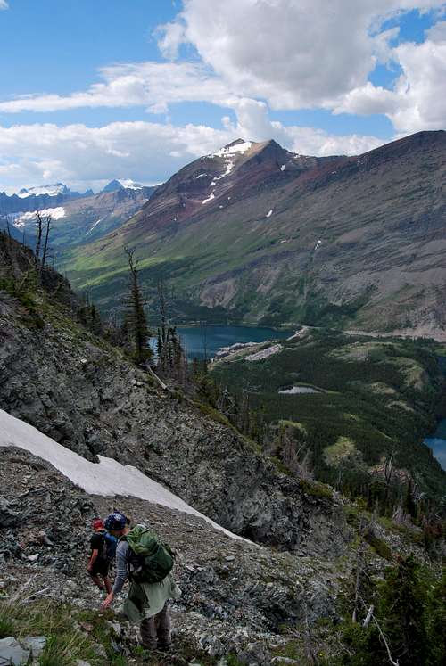
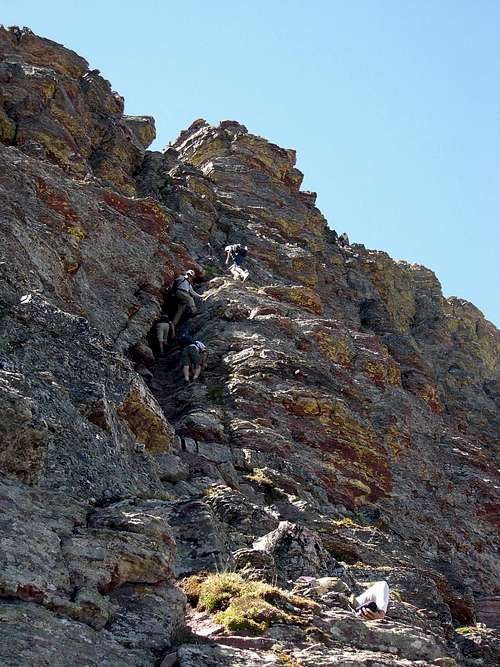
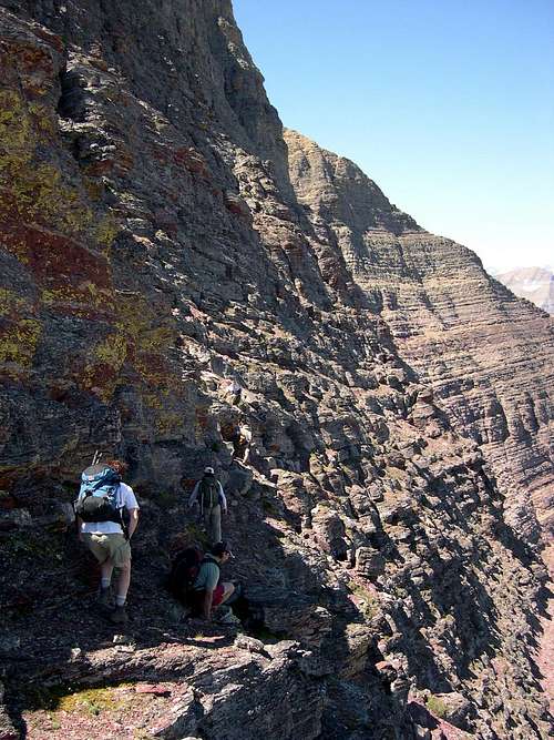
From this sublime basin, head south and climb steadily uphill on solid footing across a tundra-esque landscape. The imposing north face cliffs Allen's false summit loom at the head of the basin. Rather than head straight for the cliffs, aim for the broad ridgetop to the east, where one gets a great view of turquoise Cracker Lake and the Canyon Creek drainage far below. From the ridgetop, continue uphill, following a well-worn game trail that becomes more apparent as steep cliffs are approached. Follow the trail until it reaches impassable cliffs, at which point it traverses westward on a broad ledge. Head out onto the ledge, and look upwards for a very noticeable break in the rock - this is the Great Break that Edwards identifies in his guide. When I was here in July of 2009, a very large cairn clearly marked this spot. Negotiating the Great Break entails approximately 300 vertical feet of solid class III climbing, with a few stretches that may border on class IV due to the exposure. There are great hand and foot holds most of the way, which help make for safe passage. Eventually, you will top out on the ridge, and from hereon it's a simple class II walk up and over the false east summit before a final push to the summit proper.
Left: Approaching Allen from Snow Moon Basin. Center: Climbing the Great Break (photo by Aaron Johnson). Right: The summit ridge.
![Bushwhack Route #3]()
"Bushwhack Route" leading to the Cracker Lake Trail
"Bushwhack Route" (Cracker Lake Trail)
 |
 |
 |
 Traversing towards Schwab Falls. Allen Mountain rises in the distance.
From this sublime basin, head south and climb steadily uphill on solid footing across a tundra-esque landscape. The imposing north face cliffs Allen's false summit loom at the head of the basin. Rather than head straight for the cliffs, aim for the broad ridgetop to the east, where one gets a great view of turquoise Cracker Lake and the Canyon Creek drainage far below. From the ridgetop, continue uphill, following a well-worn game trail that becomes more apparent as steep cliffs are approached. Follow the trail until it reaches impassable cliffs, at which point it traverses westward on a broad ledge. Head out onto the ledge, and look upwards for a very noticeable break in the rock - this is the Great Break that Edwards identifies in his guide. When I was here in July of 2009, a very large cairn clearly marked this spot. Negotiating the Great Break entails approximately 300 vertical feet of solid class III climbing, with a few stretches that may border on class IV due to the exposure. There are great hand and foot holds most of the way, which help make for safe passage. Eventually, you will top out on the ridge, and from hereon it's a simple class II walk up and over the false east summit before a final push to the summit proper.
 |
 |
 |
Other Routes
"Bushwhack Route" leading to the Cracker Lake Trail
Referred to as the "Bushwhack Route" in the Edwards guide. This route provides another way to access Snow Moon Basin if snowy goat trails ain't your cup o' tea. Leave the Cracker Lake Trail just past the point where the trail nears Lake Sherburne, before Cracker Flats. Bushwhack uphill, keeping your eyes peeled for a game trail which will provide easier passage, and look for the place where the sheer cliffs suddenly become much lower. A break in those cliffs affords a class III route into the basin above, and by following game trails south you will intersect the previously described High Traverse Route that leads to Snow Moon Basin.
Cracker Lake Route
A series of class II/III cliffs can be climbed to/from Cracker Lake on Allen's south slope. Edwards describes this ascent as "unimaginative" and that the descent is "infinitely easier".
Lake Josephine Route
This route provides an easy descent back to Many Glacier Hotel, or may be used for an early season ascent when snow would make the High Traverse and Great Break routes extremely complicated. Follow the high trail along the south shore of Lake Josephine towards Piegan Pass. About half way along the lake, a massive alder-choked avalanche chute is encountered. Utilize drainages and game trails while bushwhacking uphill wherever the terrain is the most forgiving, trending up and to the right when possible (a friend of mine utilized a small dry drainage just prior to this chute to start uphill and reported relatively easy going). Trees will become a bit more sparse, and cliffs will be encountered. Head directly south (right) along the base of the cliffs, until encountering a broad class II slope. Head uphill for a great overlook of Snow Moon Basin, then slog up the class II north ridge to Allen's east summit and onward to the top.
Snow Moon Notch Route
This route involves a snow climb above the head of Snow Moon Lake to a notch in the north summit ridge, followed by an uncomplicated climb up the ridge from there. See the Edwards guide for further information.
Summit Views
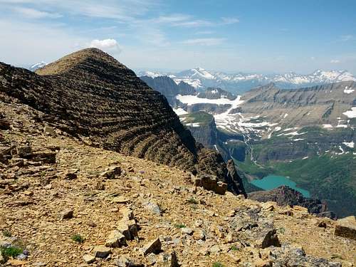
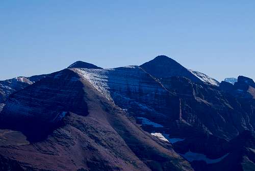
Views from the top are exceptional. The almost impossibly steep north face of Mount Siyeh is directly across Cracker Lake to the south, and a sea of peaks is visible behind. There are mighty views to the northwest that include Mount Merritt, Mount Cleveland, and the snow capped peaks of the Livingston Range. The entire Grinnell Glacier Basin is visible to the west, but perhaps the most unique view is to the north, of Many Glacier Hotel amidst a beautiful chain of lakes. I guess you'll just have to climb up there and see for yourself!
When to Climb
Due to extreme winters along the Continental Divide, problematic snow can linger on trails and mountain slopes well into July and August. Hence, the prime climbing season in Glacier is rather short, often beginning in June and lasting into late September/early October. However, some lower peaks and south facing slopes can be safely attempted much earlier in the season. Your best best is to inquire locally about snowpack and weather conditions. Personally, I have found the NOAA website to be the most reliable resource for detailed weather forecasts and snowpack information for the greater Glacier area.
Treacherous snow conditions can be expected on The High Traverse/Great Break anytime before July. Ice axe, crampons, and experience on steep snow would most certainly be requirements. Routes from Lake Josephine and Cracker Lake are mostly class II and could be attempted in June or even in May, but a lot of moderate angle snow would be encountered. At the very least, an ice axe would necessary for any early season ascents.
Where to Stay
The fantastic Many Glacier car campground is located at the terminus of the Many Glacier Entrance road, one mile past the Many Glacier Hotel. The campground has 109 sites and as of November 2016 fees are $23 per night. Be forewarned: describing Many Glacier Campground as busy in the summer months is nothing short of an understatement. From mid-June to Labor Day, the campground almost universally fills well before noon. As of 2016, the NPS has implemented a reservation system and half the sites are reservable in advance. The remaining sites are available on a first-come, first-serve basis only. If you do not have a reservation, I recommend arriving before 7am to line up in the queue of walk-up campers. Information on historic campground fill times, reservations and camping regulations can be found on the NPS camping webpage.
Many Glacier Hotel offers 215 rustic rooms in a spectacular setting on the eastern shore of Swiftcurrent Lake. The hotel turned 100 in 2015, and does not have many modern amenities. It is extremely busy during the summer, and the concessioner recommends booking several months in advance. Rates range from approximately $150 to nearly $300 per night, with the majority of rooms in the $200 range. Visit Xanterra’s website for more information. There are also numerous local lodging opportunities (campgrounds, motels, cabins) just outside the park in and around the small towns of Babb and St. Mary.
There is a beautiful backcountry campsite at Cracker Lake, which is immediately south of Allen Mountain. From camp, it's possible to ford the outlet creek (or hike clockwise around the lake) to ascend the loose southern slopes of Allen. As of November 2016, permits are $7 per person per night and can be obtained at various visitor’s centers (St. Mary and Many Glacier are nearest). There is an advance reservation system (and associated fee), or sites can be obtained on a walk-up basis. Please visit the NPS backcountry camping webpage for more detailed information.
Red Tape, Safety, Wildlife, etc.
Entrance Fees
A fee is required for all persons entering Glacier National Park. As of April 2020, single vehicle rates are $35 for a seven day pass, or $25 in the winter. Glacier National Park’s annual pass is $70 and provides valid entry for the purchaser and private vehicle passengers for one year. Lower entrance fees are charged for motorcycles, bicyclists, and hikers; please visit the NPS website for a full explanation of entrance fees: NPS Glacier entrance fees.
Seasonal Closures
Glacier is subject to extreme winter weather conditions, and as such, much of the park is virtually inaccessible for the majority of the year. The Going-to-the-Sun Road is typically open in its entirety from mid-June to mid-September, and many of the developed areas of the park (including the historic lodges and most of the campgrounds) operate for a short window as well. Information on the operational status of front country campgrounds and park roads can be found by clicking on the hyperlinks.
Glacier Rock Grading
Due to the sedimentary nature of the rock in Glacier National Park, unique rock grading systems have been established by both Gordon Edwards and the Glacier Mountaineering Society. Please refer to the Glacier National Park Rock & Grading Systems Summitpost page (authored by Fred Spicker and Saintgrizzly) or the website of the Glacier Mountaineering Society for detailed information. If you are new to climbing in Glacier, I highly recommend checking out this info before attempting any climbs in the park. Oh, and don't forget to wear your climbing helmet!
A Climber's Guide to Glacier National Park Pick up a copy of Gordon Edwards' classic A Climber's Guide to Glacier National Park. It's an absolute must for anyone who wants to safely venture to one of the park's many accessible mountain summits. Edwards spent many years as a seasonal ranger in Glacier, where he developed a deep passion for exploring the park's mountains and sharing its splendors with others. The book provides a fantastic history of climbing in Glacier, and his detailed and colorful route descriptions are a fantastic introduction to off-trail hiking and climbing in the park.
![grizzly bear off Many Glacier Road]()
Hey bear!
Wildlife
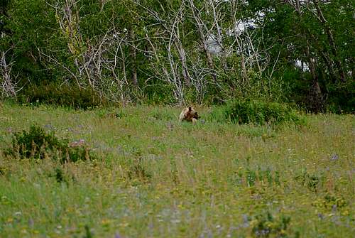
Hey bear!
The park is home to lots of potentially dangerous wildlife, including moose, black bear, grizzly bear, and mountain lion. Hike loud, carry bear deterrent spray (and know how to use it!), check local trail postings (for area warnings/closures) and let someone know your itinerary before heading out into the park. Also, note that special precautions are in place in all front and back country campgrounds to limit human-bear encounters. Regulations are posted everywhere (picnic tables, ranger stations, bathrooms) and it is every visitor's responsibility to take them seriously. Remember, a FED BEAR IS A DEAD BEAR! Please visit the NPS camping webpage for more detailed information.
External Links
Visit the FANTASTIC Glacier National Park page, a labor of love by late Summitpost member Saintgrizzly (R.I.P.), or the NPS webpage for more detailed information on "The Crown of the Continent".
References
1. Edwards, J. (1995). A Climber's Guide to Glacier National Park (1st edition published in 1961). Helena, MT: Falcon Press Publishing Co., Inc.
Special Thanks
Approaching the Great Break -- Aaron Johnson photo
Parting Shots
Click on the individual photo for more information. Enjoy!
 |
 |
 |