


-
 12150 Hits
-
 85.36% Score
-
 20 Votes
|
|
Mountain/Rock |
|---|---|
|
|
46.10387°N / 8.86599°E |
|
|
Hiking, Skiing |
|
|
Spring, Summer, Fall, Winter |
|
|
6437 ft / 1962 m |
|
|
A Proposal
I am just starting this page. It happened that we were late and that February slopes were very hard, even icy, so we did not go from above Corte di Sopra on top. There are certainly many members who were on top of this exciting mountain and are more knowledgeable about it than me. Don't hesitate to contact me and I will give you the ownership.Overview
Monte Tamaro is a very popular mountain. Holding a dominant position between two famous alpine lakes it is a great hiking goal. Well maintained paths are coming on top from all sides, even a mountain road reaches its high slopes. From the north-east a cable-car goes up on Alpe Foppa, to be more precise, on Corte di Sopra, 1530 m. So most of visitors take just a short, good one hour hike, those more ambitious however usually choose longer, very panoramic ridge traverse - as far as there to Monte Lema. The mountain is also very popular with mountain bikers.From the summit, the W ridge descends to the saddle of Alpe di Neggia, 1395 m. More towards the west there is already Monte Gambarogno, a very panoramic summit, suitable also for tour skiing.
Towards the S, from Monte Tamaro another strong ridge deters, culminating soon in Monte Gradiccioli, 1936 m. This ridge enables a nice round tour in summer, and Monte Gradiccioli is also a nice summit for tour skiing.
 Gabriele - The NNW side of Monte Tamaro Gabriele - The NNW side of Monte Tamaro |  Monte Tamaro from the W-NW Monte Tamaro from the W-NW |  Monte Tamaro from Alpe Foppa Monte Tamaro from Alpe Foppa |
 Gangolf Haub: Monte Tamaro from Monte Gradiccioli Gangolf Haub: Monte Tamaro from Monte Gradiccioli |  Gangolf Haub: Monte Tamaro south ridge Gangolf Haub: Monte Tamaro south ridge |  Gangolf Haub: Monte Tamaro from Minusio Gangolf Haub: Monte Tamaro from Minusio |
Mario Botta
Monte Tamaro is also very known by a modern church Santa Maria degli Angeli (1996) of the famous Swiss architect Mario Botta. It is worth visiting a few web sites about him, even better is of course visiting his masterpieces "in situ".- Santa Maria degli Angeli: http://www.galinsky.com/buildings/montetamaro/
- Mario Botta's oficial page: http://www.botta.ch/
 |  |  |
Summit Panorama
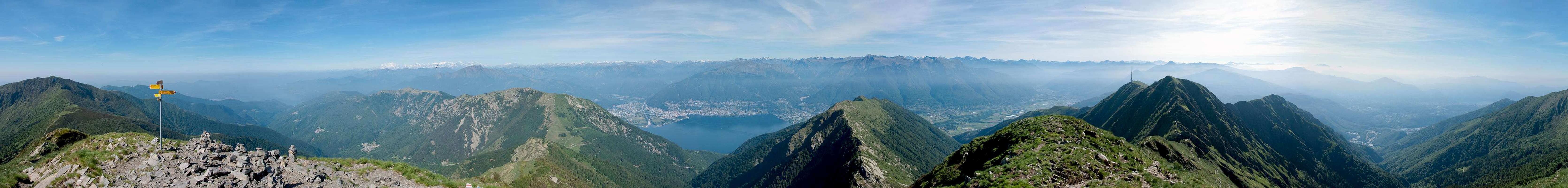  |
The view from Monte Tamaro, and also from Alpe Foppa is indeed a stunning one. Deep below us is Belinzona, the southern gate of high passes over Alps. Valleys above the town are branching and above them hundreds of peaks are rising. Towards the east views go to Bernina group and towards the west to Wallis fourthousenders, including Monte Rosa, Matterhorn and Dom. Ticino/Tessin can be perfectly overlooked.
As I was not on top, a few words about the views on lakes and towards Lombardia must be obviously missing.
|


Getting There / Routes
 Indemini in spring
Cable car. The lower station of cable car is in Rivera, just SE of Monte Ceneri pass, on the Lugano side. It operates from start of April till start of November, daily from 8:30 to 17:00.
 Luca - Indemini Luca - Indemini |  Mathias Zehring - Alpe Canigiolo Mathias Zehring - Alpe Canigiolo |  Below Corte di Sopra Below Corte di Sopra |
Monte Ceneri pass connects the area of Lugano lake with the area of Maggiore lake. From the pass a mountain road ascends towards the summit of Monte Tamaro. But the road is closed for public traffic just one or two hundred meters above Monte Ceneri pass, on some 580 m.

- The ascent from the parking place above Monte Ceneri, 580 m, to Mario Botta's church will take you some 2 h 30 min, from Alpe Foppa on top additional 1 h 15 min. In summer the path on top is easy.
- As said in the overview: The ridge traverse hike from the cable car to Alpe Foppa via Monte Tamaro, Monte Gradiccioli and so on to the cable car on Monte Lema can't be beaten in terms of views to lakes and mountains and is one of the most popular hikes in Switzerland. It is well organised with a bus service that will bring you back to Monte Ceneri.
- The ascent on Monte Tamaro from the western-northwestern side can be quicker. The road which crosses the pass on Alpe di Neggia reaches 1395 m. See also the picture on top right of this page - the whole path is well seen on it.
- A more lonely but longer daytrip starts south east of the mountain at Arosio (859 m - parking possible at the end of a pave road at app. 950 m). To reach the beginning of the real climb you have to walk app. 7 km on a forest road to Pian Cusello (1343 m). Using a bike here may be an option to shorten the day. A marked trail leads to the top in app. 2 h. The best option for returning is to enjoy the ridge hike to Monte Gradiccioli (1936 m) and descend to Arosio via its south east ridge.
If you look for a strenuous but lonely adventure: The north ridge of Monte Tamaro starts at Quartino at 216 m. There is always a path, but not marked between Forcarella (1045 m) and Poncione dela Croce (1471 m).
A great tour is also mountain biking from Lugano - on Monte Tamaro - down to Rivera and back.
Mountain Huts
- On Alpe Foppa, near the upper station of cable-car, there is a restaurant.
- On the saddle Corte di Neggia there is a mountain hut: Ritrovo di Neggia, 1395 m. Opened from April to October, tel.: 091/7951997.
Red Tape
 Below Alpe Foppa
No restrictions.
When to Ascend?
Monte Tamaro can best be ascended in times when cable-car is operating. In winter the ascent can be harder and longer, so take also winter equipment. Most important is to chose a day with clear air which is much more likely to be in autumn and winter season than in spring or summer.External Links
- swiss online map
- Monte Tamaro official tourist site: http://www.montetamaro.ch/