

-
 17968 Hits
-
 90.81% Score
-
 33 Votes
|
|
Mountain/Rock |
|---|---|
|
|
46.38710°N / 8.31849°E |
|
|
Mountaineering, Skiing |
|
|
Spring, Summer, Winter |
|
|
10614 ft / 3235 m |
|
|
Overview
Shared between Switzerland and Italy, the Ofenhorn (Swiss name) or Punta d'Arbola (Italian name) is a border peak in the Lepontine Alps.
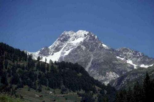
Ofenhorn seen from the village of Binn
From a Swiss point of view, the Ofenhorn is a landmark of the Binntal, famous for its minerals. It marks the north-eastern end of the valley. The Binntal is a side valley of the large Rhone valley east of the city of Brig.
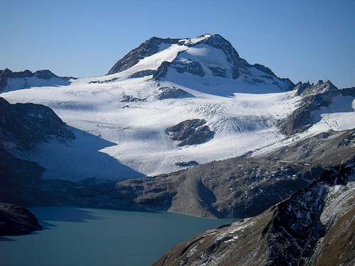 Punta d'Arbola with Lago del Sabbione at its base
From an Italian perspective, Punta d'Arbola lies in the remote western corner of the scenic Val Formazza. The area is dotted with lakes, many of which are used to generate hydro-electric power. The largest, Lago del Sabbione, lies at the northern base of the mountain.
Val Formazza is a dead end, surrounded by high mountains to the west, north and east. The only road into the valley is from the south, from the town of Domodossola.
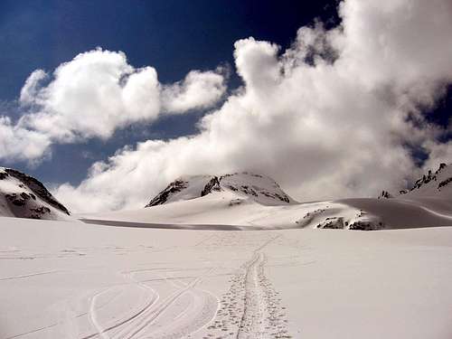
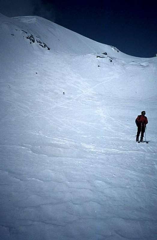
Ski tracks across Lago del Sabbione
The mountain is climbed from all sides in summer, but the main interest is in late winter and spring for ski-mountaineering, predominantly on the Italian side.
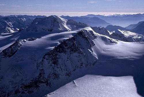
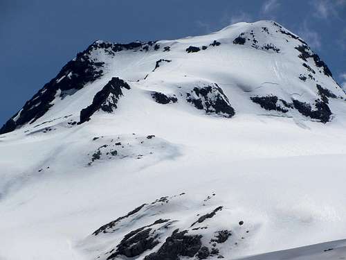
 Early morning summit view
Ridges and Faces
Google terrain view centered on Ofenhorn / Punta d'Arbola.Zoom in for a closer view, or Click here for a larger map
Ridges
There are many ridges that define the mountain, three of which coming together right on the summit.
Ofenhorn and Hohsandhorn from Blinnenhorn
Northwest Ridge
A steep rocky ridge starts out towards the NW, soon turns north and then NE, reaching the Hohsandjoch / Passo del Sabbione (2901m) about 1 km north of the summit. The border follows the ridge. After the pass, the now jagged rocky ridge rises again to culminate in the Hohsandhorn / Punta del Sabbione (3182m).
From there it continues to the Blinnenhorn / Corno Cieco (3374m) without ever dropping below the 3000 m mark. That makes the Hohsandjoch the key saddle, giving the Ofenhorn / Punta d'Arbola a prominence of 334 m.
Southwest Ridge
A second rocky ridge, exposed and a bit steep near the summit, starts out to the SW. After about half a kilometer, at a subsidiary summit (3164 m), it splits into a west and a south ridge. First the SW and later the south ridge define the border.
East Ridge
In contrast to the rocky border ridges, a wide and gentle ridge extends to the east, into Italy. After no more than 100 m it splits into the somewhat steeper southeast and northeast ridges.

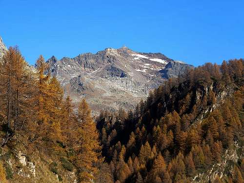
Punta d'Arbola from Cima Cust
Not all that long ago, the NE ridge was mostly covered with snow, but as the glacier is melting, more and more rocks have come through. The upper part is wide and gentle, lower down it gets steeper and more exposed.
The rocky SE ridge starts out easy too, but gets steeper soon as it turns south and descends quickly to the Ofenjoch (3010m), and then onward to Cima Cust (3045m), a minor subsidiary.
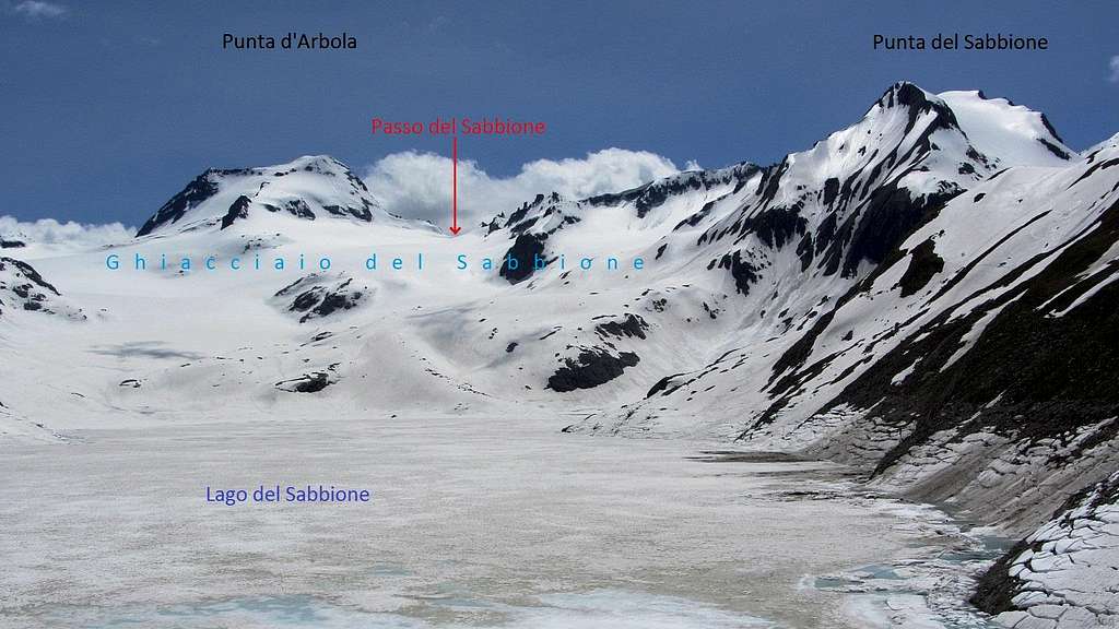 Panorama of Punta d'Arbola, Passo del Sabbione and Punta del Sabbione from the north, across Lago del Sabbione
A closer view of Punta d'Arbola from the NNE.
On the right is the steep NW/N ridge. At the top and on the left is the E/SE ridge, joined from the lower left by the NE ridge not far below the summit. This picture clearly shows the steepness of the N face directly next to the NW/N ridge, while the eastern slopes are gentle.
Faces
There are four main faces.
North and East Faces
The glaciated north and east sides, all in Itally, are the home of the Ghiacciaio del Sabbione (ghiacciaio = glacier). On the right, the north face is steep, but on the left, next to the NE ridge it is relatively gentle. On the other side of the NE ridge, the eastern slopes are gentle.
To the north, the glacier used to flow directly into Lago del Sabbione (2466m), but it doesn't quite reach the lake anymore. On the east side of the glacier, NE of the mountain, lies Passo del Vannino (2754m), also known by the name of Passo Lebendun, at the head of the Vallone del Vannino.
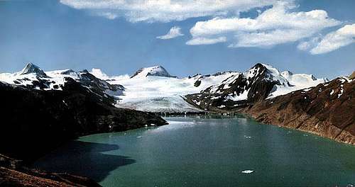
An old photo, showing Ghiacciaio del Sabbione almost reaching the lake
South Face
Still in Italy, wedged between the southeast and southwest ridges, is the south flank, former home of the all but gone Arbolagletscher / Ghiacciaio d'Arbola.
West Face
The rocky west face is the steepest, and the only one in Switzerland. At its bottom, shaded by the west ridge to its south, lies the small Tälligletscher.
Getting There
Three different access routes to the area:
From Switzerland - Wallis

The small church of Binn
To get to the Ofenhorn, first travel to Binn (1400m), a small old town in the Binntal. With public transport, Binn can be reached by bus from Fiesch, which in turn has a train station on the service between Brig and Andermatt. From Binn, a taxi service is available for transport up the Binntal to a point just 1.5 hours from the two huts, the Binntalhütte and Mittlenberghütte. The taxi can be contacted through the Tourist Office in Binn, or called from the huts.
By car, the N19 connects Brig with Andermatt via the high Furkapass (2429m). When there is too much snow and this pass is closed, Fiesch can still be reached by taking the car-train or by road from Brig. Less than 2 kilometers before Fiesch is the turnoff to the Binntal. The small road heading up the valley passes through the famous historic village of Ernen, with its many old buildings. From Binn follow the route to Fäld (1519m) where you can park your car.
From Italy - Val Formazza
Val Formazza is the northern extension of Valle Antigorio. At its southern entrance lies Domodossola, the main city in the area. This is the first Italian stop on the major international train service from Brig, Switzerland to Milan, Italy. From Domodossola buses go north to Val Formazza.
A highway connects Milan and Domodossola, turning west towards Switzerland and the Simplon pass immediately north of Domodossola. For Valle Antigorio and Val Formazza, leave the highway and continue north on a smaller road, which continues as far as Lago di Morasco (1815m). There is room to park at the bottom of the dam, at around 1750 m. In spring, the road is normally open only until Riale (1740m). Along the road there are three suitable trailheads:

Vallone del Vannino

Youngsters at Rifugio Claudio e Bruni
- From Valdo (1276m) head west, ascending Vallone del Vannino (in winter and early spring a chairlift can save over than 1 hour) to Rifugio Margaroli (2196m) on the banks of Lago Vannino.
- From Canza (1419m) to the south for about 2 kilometers is another way to reach Vallone del Vannino. It's a bit longer in distance but requires less elevation gain.
- From Riale or from the parking area at the base of the dam at Lago di Morasco there are three more options.
- The shortest one is to hike up the Vallone del Sabbione to one of several refuges around Lago del Sabbione: Rifugio Cesare Mores or Rifugio Somma Lombardo northeast of the lake, or, a bit further, Rifugio Claudio e Bruno on the slopes west of the lake.
- Follow the fine mule track in the direction of the Passo del Gries / Griespass to get to the Bettelmatt plateau. Turn left there, and soon you'll reach Rifugio Città di Busto.
- Go up the Vallone di Nefelgiù to the Passo di Nefelgiù (2583m). A short descent on the other side leads to Rifugio Margaroli.
Punta d'Arbola from Alpe Devero
From Italy - Alpe Devero
South of the mountain, hugging the Italian side of the border, lies the Parco naturale dell'Alpe Veglia e dell'Alpe Devero. This area is accessible by car or by bus via Valle Devero, a side valley of Valle Antigorio. Alpe Devero itself lies just outside the park at the end of the road.

Lago Devero
It will be a long day, but Punta d'Arbola can be climbed from Alpe Devero, starting by following the trail to Lago Devero and after that towards Colle Scatta Minoia. The unmanned Bivacco Ettore Conti is located on this saddle.
Routes
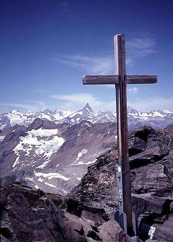
Ofenhorn, Summit cross
All routes on the mountain require some experience. Some routes involve glacier travel, others easy rock climbing.

View south from high on Ofenhorn
South Flank, F+
Although the last part of the ascent is in Italy, this is considered the normal route from Switzerland. From the Binntalhütte (2275m) head ENE to the Eggerscharte (2857m), a gap on the south ridge about 1 km from the summit. On the other side of the gap is a bowl, once covered by the Arbolagletscher / Ghiacciaio d'Arbola, but there isn't much left. The route straight up the bowl to the summit gets rather steep higher up, therefore it is easier to aim for the crest of the east ridge, a bit to the right of the summit, and follow the ridge to the top. 3 hours from the Binntalhütte.
A longer alternative from the Eggerscharte, involving a bit more scrambling, is to aim ENE to the Ofenjoch (3030), the gap in the ridge directly north of Cima Cust (3045m), and follow the rocky ridge to the summit.
The south flank is also the shortest route from Alpe Devero and from Bivacco Ettore Conti.
Eastern Slopes, F
From Italy, this is the normal route. The nearest refuge is Rifugio Claudio e Bruno (2708m), NNW of Punta d'Arbola, on the western slopes above Lago del Sabbione (2466m). The route first passes east of Punta del Sabbione, dropping some 100 m in the process, to reach the Ghiacciaio del Sabbione, then aims just left of the NE ridge to get to the easy eastern slopes. 2.5 to 3 hours from Rifugio Claudio e Bruno.
For the same route from Rifugio Somma Lombardo or Rifugio Mores, both near the dam at the northeastern end of Lago del Sabbione, add one hour in summer, following a trail on the west side of the lake, or much less when the lake is frozen solid and you can go across. Be aware that this is a reservoir used to generate hydroelectric power, and when the water level is lowered the ice quickly becomes unreliable. When in doubt, ask the energy company employees stationed at the house at the dam.
For the same route from Rifugio Città di Busto, add another half hour to reach the dam of Lago Sabbione.
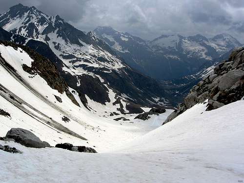
View down Vallone del Vannino from Passo del Vannino
When coming from Rifugio Margaroli (2196m), head up the slopes of the Vallone del Vannino to the Passo del Vannino (2754m). Once on the pass, it's just a short walk to the base of the eastern slopes.
Finally, this route can easily be climbed from Switzerland as well. The shortest way is from the Mittlenberghütte (2394). Located due west of the mountain, the route starts out towards the ENE, to the Hohsandjoch / Passo del Sabbione (2901m). Across the pass the route heads east, traversing the north side of the mountain without losing much altitude to get to the base of the eastern slopes. 3 hours from the hut.
Where the normal route follows the easy slopes on the east side of the NE ridge, a hardly more difficult variation follows the north side of the same.
From the Binntalhütte, the west ridge is gained from the south, about 1 km west of point 3186, where the south ridge joins. From there, follow the SW ridge to the summit (UIAA grade II).
Ski Routes
The best descent route is down the eastern slopes to Passo del Vannino and then all the way down the Vallone del Vannino. If the lakes are frozen solid, an alternative is to descend the eastern or northeastern slopes, then cross Lago del Sabbione, ski down the Vallone del Sabbione and cross Lago di Morasco. However, this involves two flat sections where you have to expend some energy: 2 km for Lago del Sabbione, and almost 1 km for Lago di Morasco...
To Switzerland, the best descent route is to go down the northeastern or eastern slopes and then over the Hohsandjoch / Passo del Sabbione to the Mittlenberghütte. A harder route is down the steeper south flank and across the Eggerscharte to the Binntalhütte. From both huts it is possible to continue skiing down the Binntal.
Refuges and Camping
Swiss side
- Binntalhütte (2275m), located at the southwest base, owned by the Swiss Alpine Club.
From Binn (1400m) or from Fäld (1547m), hike up the Binntal along the small river Binna, first to Freichi and then to Blatt (2109m). Turn right on the marked path to the Binntalhütte. About 3 hours from Fäld, or half an hour more from Binn. - Mittlenberghütte (2394m), due west of the mountan. This private hut offers better access to the Italian normal route.
Up to Blatt the approach is the same as for the Binntalhütte, but turn left instead of right. Also about 3 hours from Fäld. The two Swiss huts are not all that far apart.
The Binntal is a nature reserve, and camping is only allowed at the campground in Binn (simple, cheap, but very nice). Website of the campground: www.camping-giessen.ch. Binn itself has several hotels.
Italian side - Val Formazza
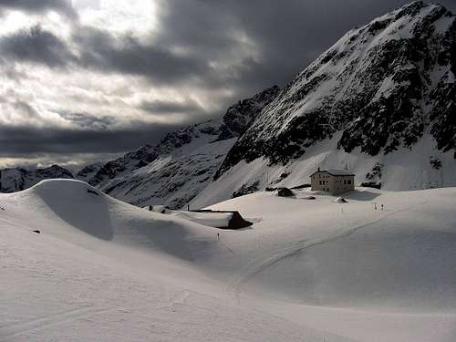
Rifugio Margaroli on the banks of Lago Vannino
- Rifugio Margaroli, right by the dam at Lago del Vannino (2196m). Easy to reach by hiking up the Vallone del Vannino, in 2 hours from Caldo or 3 hours from Canza. A prime location for ski-mountaneering. From the same hut you can visit several other peaks, such as Punta Clogstafel and Monte Giove.
- Rifugio Cesare Mores (2515m) lies next to the dam northeast of Lago del Sabbione and 10 minutes higher up is Rifugio Somma Lombardo (2561m). The shortest route is from the end of the road in Val Formazza, following the northern shores of Lago di Morasco and then up the Vallone del Sabbione, 2 hours.
- Rifugio Città di Busto (2480m) is half an hour north of Lago del Sabbione. From Lago di Morasco, instead of hiking up the Vallone del Sabbione, head in the direction of the Passo del Gries / Griespass to get to the Bettelmatt plateau. Turn left there, and soon you'll reach Rifugio Città di Busto, also 2 hours from the end of the road.
- Rifugio Claudio e Bruno (2708m) lies on the western slopes above Lago del Sabbione, one hour from the dam.
In late spring (when the road is open) and in summer free camping is possible near the dam at Lago di Morasco (campers and motorhomes are a normal sight there).
Italian side - Alpe Devero
No camping is allowed in the park itself, but there are various options just outside, near the end of the road in the Valle Devero, such as Capanna Enrico Castiglioni all’Alpe Devero (1640 m). And further north, conveniently located on Colle Scatta Minoia is the unmanned Bivacco Ettore Conti (2598m).
When To Climb
For hiking and climbing the best months are June, July and September (sometimes October); in August the micro climate (caused by the big lakes and glaciers) often brings foggy days and poor weather.
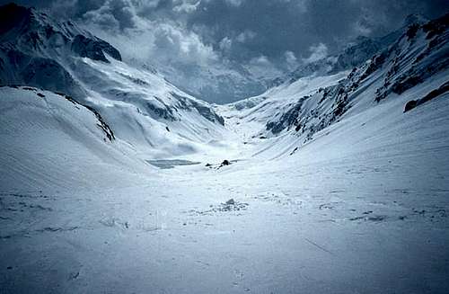
 Gloomy weather over Lago del Sabbione...
In late winter and in spring Ofenhorn / Punta d'Arbola is quite popular by ski or snowshoe.
 |
 |
 |
Red Tape
The whole Binntal is a nature reserve, as is the Parco Naturale Veglia Devero.
Mountain Conditions
Swiss weather forecast: On Meteo Schweiz select wetter/detailprognose/lokalprognose and then select "Binn" as location.
Italian weather forecast for Alpe Devero
Maps
The 1:25 000 Swisstopo maps are easily the best and most detailed ones available, but each map covers only a relatively small area.
Map 1270 Binntal covers Ofenhorn / Punta d'Arbola and the routes from Switzerland.
Map 1271 Basòdino is the adjacent one on the east and has the lower part of Vallone del Vaninno and Lago di Morasco.
Map 1290 Helsenhorn is the adjacent one on the south and covers the route from Alpe Devero.
The 1:50 000 Swisstopo maps are still excellent. The bottom half of map 265 Nufenenpass covers the same area as the more detailed 1270 Binntal and 1271 Basòdino, and map 275 Valle Antigorio covers the whole area further south.
A good alternative, also 1:50 000 though not quite as detailed as the Swiss maps, is the Italian IGC map 11, "Domodossola e Val Formazza", 1:50 000. As the name says, this map covers a much larger area.
External Links
In Memory of Stefan "kletterwebbi" Weber
This page was originally created by "kletterwebbi".
Stefan Weber, the member we all used to know by his climbing pseudonym kletterwebbi, died on May 28th 2004 in southern France.
Stefan joined SP early on in 2002 and contributed a number of excellent pages and routes to this site. He was an accomplished climber excelling in difficult alpine and technical routes. The Dolomites, especially the area around Gröden / Val Gardena were special to him, as it was his old ancestral home.
kletterwebbi was always willing to share his knowledge and experience with other climbers, mainly here on SP, but also on other sites. He contributed his IT expertise as webmaster of his local section of the German Alpine Club, where he also engaged in leading trips for fellow members. Besides his climbing and mountaineering activities he was a musician, a composer of contemporary music. Stefan will be greatly missed by us all.
Stefan's SP page