
-
 21069 Hits
-
 78.27% Score
-
 9 Votes
|
|
Mountain/Rock |
|---|---|
|
|
37.15322°N / 121.93516°W |
|
|
Santa Clara |
|
|
Hiking |
|
|
Spring, Summer, Fall, Winter |
|
|
2716 ft / 828 m |
|
|
Overview
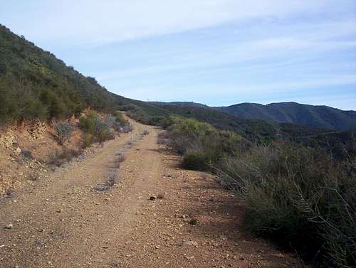
Ralph's Mountain isn't much of a mountain. In fact, it is barely even a summit, merely a small rise along a ridge on the southern slopes of Mt. Thayer, separating Hooker Gulch and the Wrights Station canyon. Ralph's Mountain is located in the Cathedral Oaks area of the Sierra Azul Open Space preserve, close to Mt. Umunhum. This is a remote area of the Santa Cruz Mountains and a sparsely used area of the preserve. This is the main appeal of the hike to Ralph's Mountain. Even though the trail to Ralph's Mountain is maintained and in good shape, it does not appear on the Sierra Azul trail map, partly because this area of the preserve is surrounded by private property on almost all sides, however, the hike is entirely legal. A fire road begins at a gate off of Wrights Station Rd and completes 15 switchbacks through dense chaparral before topping out on the ridge and summit of Ralph's Mountain. The summit is interesting in that there is a grove of rather large Cedar trees in the middle of the chaparral covered hillside. The views are good to the north, with a close-up view of Mt. Thayer, and an interesting perspective of the Almaden Air Force Station as well. To the south, Summit Rd. can be seen on the ridge across the valley. Beyond that, Monterey Bay opens up in a vast, usually fog covered array. At the summit, nailed to the trunk of the largest Cedar tree, is an old, wooden sign reading "Ralph's Mountain". This hike is perfect for a quick afternoon outing if you want to get away from the high tech hustle and bustle of Silicon Valley for a few hours.
The Trail
If the hike to the summit isn't enough, there are more attractions in this area. Be sure to check out the Wrights Station Tunnel near the parking lot. This was the first of a series of tunnels that ran through the mountains back in the day of the railroads. Many beach go-ers of the late nineteenth century passed through Wrights Station en-route to Santa Cruz on the trains. The 1906 earthquake severely damaged the tunnel, and it was eventually sealed up when Highway 17 was built around 1940. What remains now is just the entrance.

Wrights Station Tunnel
If one is feeling brave, one can sneak his or her way up to Lake Elsman, which is located just .75 miles up the canyon from the trailhead. Don't say I told you that, though.
Ralph's Mountain is also surrounded by the proposed logging plan put out by the San Jose Water Company. This plan has received so much criticism from the town of Los Gatos and the local mountain folk that it is probably not going to happen, which is a good thing.
Wrights History
The tunnel was bored by the South Pacific Coast Railroad in 1878-79. This tunnel was the first of several the railroad bored on their way through to Felton, and ultimately, Santa Cruz. It was the longest, being over 6200 feet in length, and was in service until the mid-30's. The tracks were torn out during WWII. The wall of dirt inside is the result of it being dynamited at that time for fear of the Japanese invading the west coast and possibly using it for a hiding place and staging area.
Wright's (as it was then called) was named after Reverend James Richard Wright. A retired minister, he settled here in 1870 on 48 acres of land with his wife and ten children. When the railroad came through in 1879, Wright's became an important shipping point for local farmers and was quite the busy place at the turn of the last century, sporting a general store, a hotel, and picnic grounds as well as the train station, a water tank, and loading siding. The town was abandoned in 1940. With the new highway bypassing the old railroad route, and after the trains quit running, like so many towns, Wright's withered up and died.
Thanks to Dwight with all of this great information.
Getting There
Take highway 17 south out of San Jose, traveling through Los Gatos. Follow the highway into the mountains and exit Summit Road, 6.75 miles after Los Gatos. Take a right onto Summit, going over the bridge. After the bridge, turn left and continue on Summit Road. Go 2.5 miles on Summit and turn left onto Morrill Road. Go about .75 miles on Morrill Road and look for the first left turn. This is Wrights Station Rd. There is no sign, but it is hard to miss considering that it is the first and only turn off of Morrill Road. Travel down Wrights Station, switchbacking into the canyon. The road is a one-lane road, twisting through nice shady Redwoods. Soon you'll begin to see a few "No Trespassing" signs posted on the trees. These are Water Company signs, pay no attention to them. When the road reaches the bottom of the canyon, there is a large dirt pull-out on the right, just before the bridge goes over Los Gatos Creek. Park here in the pullout. The Wrights Station tunnel is located off the road to the south of the pullout, behind a small fence. Hop the fence and proceed about 50 yards to the tunnel.
For the hike to Ralph's Mountain, walk over the bridge, crossing Los Gatos Creek. The road turns right and continues alongside the creek. When the pavement ends, you will see a road turn left, up the hill. This road is paved. Walk up the paved road and there is a rather large gate, signed "Authorized Vehicles Only". Walk pass the gate and continue on the pavement. Soon you will pass a Sierra Azul gate on the left. Don't go up this trail. Stay on the pavement and you will come to another Sierra Azul gate on your right. This is the correct gate. Walk through the gate and continue up the fire road. The fire road begins to climb through a shady redwood forested gulch, then emerges into the sunny chaparral. At the first fork, take a left for Ralph's Mountain. The trail to the right leads to the top of the neighboring ridge with nice views of Austrian Gulch and Lake Elsman. After taking the left at the fork, continue about 2.5 miles to the summit of Ralph's Mountain. Re-trace your steps.
Stats: from parking spot is about 3 miles, 1.5-2 hours. 1800 foot elevation gain.
Red Tape

Mt. Thayer
The hike itself is completely legal. Accessing the trail and trailhead is not. The access road that leads to the trailhead from the canyon floor is signed "Private Road Keep Out", and is adorned with a heavily fortified gate.
Mountain bikes and horses are allowed on the trail.
There is no camping any where in the Sierra Azul Open Space preserve.
expedia - May 15, 2010 3:20 pm - Hasn't voted
More Red TapeThere is not a legal entrance to the Cathedral Oaks Sierra Azul. Where you park is on private property and the road leading to the entrance is on private property. There is a sign that states residence only. PLEASE COMPLY
McCannster - May 15, 2010 3:27 pm - Hasn't voted
Re: More Red TapeOKAY I WILL COMPLY
AlphaRomero - May 15, 2013 8:40 pm - Hasn't voted
Re: More Red TapeI scouted the area today. It's much more clear now. Rather than the road saying "Authorized Vehicles Only", it now says "Private Road, Keep Out". I did not go past the sign. Too bad!
McCannster - May 16, 2013 8:37 pm - Hasn't voted
Re: More Red TapeBummer! Land owners can be needlessly selfish sometimes when it comes to these things I guess. I will update the page.