|
|
Mountain/Rock |
|---|---|
|
|
49.09800°N / 20.03100°E |
|
|
7979 ft / 2432 m |
|
|
Overview
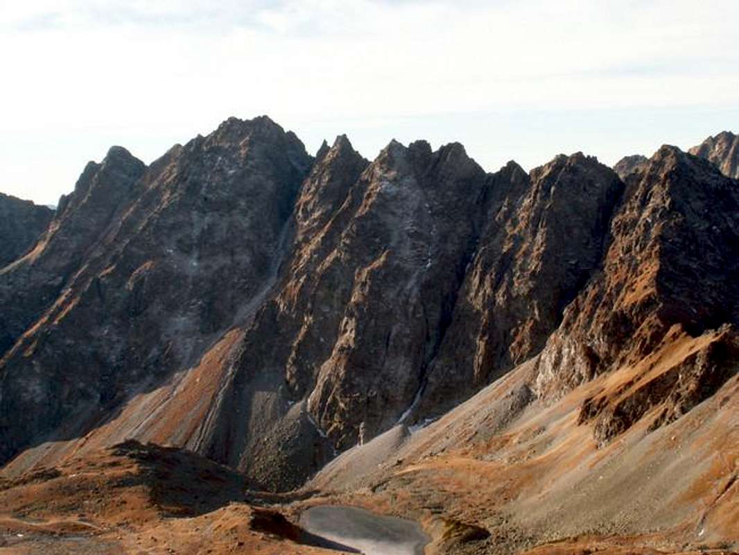
Satan is the one of the most outstanding summit in High Tatra and the highest summit in Hrebeň Bašt / Grań Baszt Group (“Ridge of Dungeons”) – huge rocky wall ascending between Mengusovská / Mięguszowiecka Valley and Mlynická / Młynicka Valley. It is a part of the longest lateral ridge of High Tatra, which culminates in Kriváň. Except Hrebeň Bašt and Kriváň there are following summits such as Štrbský Štit / Szczyrbski Szczyt, Hrubý Vrch / Hruby Wierch, Soliska / Grań Solisk and Ostrá / Ostra (don’t mislead with Ostrý Štit!).

Hrebeň Bašt with the highest Satan from Mięguszowiecka Pod Chłopkiem Pass
Even though there is no marked route leading on the top this summit is much often visited by tourists than by climbers, first of all for a beautiful view which spreads on a whole Mengusovská Valley with its all branches in the north-east direction, Gerlachvský Štit in the east and Kriváň Group in the west. For climbers Satanova Galéria / Galeria Szatana is interesting with a few aid routes of a difficulty’s middle grade (see “routes overview”).
Satan has two summits: the north and the south with similar altitude. It is separated from Predná Bašta / Pośrednia Baszta by Sedlo nad Červným Žlebem / Przełęcz nad Czerwonym Żlebem in the south and from Diablovina / Diablowina massif by Satanovo Sedlo / Szatania Przełęcz in the north.
The Slovakian and Polish name means “satan” and refers to a legend about devil, which hid gemstones in Satanov Žl’ab / Szatanowy Żleb (Devil’s Couloir) (falling down from Satanovo Sedlo). A shepherd, which pastured sheeps in Mengusovská Valley, prompted a wizard to find this treasure. But when they started to look for in the couloir the devil stoned them. And till today when climbers want to reach the summit by this couloir stones fall down. Really! :).
First ascend
Jan G. Pawlikowski with a guide Maciej Sieczka and Johann Strompf reached the summit as the first in 1880 year.
In winter the first ascend belongs to Ernst Dubke and guides Johann Breuer junior and Johann Franz senior (1906).
Summit view
It is excellent! See yourself :)
Getting There
FROM SLOVAKIAN SIDE:
The major city in this area is Poprad, where you can get by bus or train. From Poprad there is a lot of buses and trains to Starý Smokovec (13km) at the foot of Tatra:
train time table
bus time table
train time table from Poprad to Starý Smokovec Tatranská elektrická železnica
Maps of Starý Smokovec and Tatranská Lomnica
From Starý Smokovec take a bus (time table) or train (more recommended) (Tatranská elektrická železnica) Popradské Pleso (it is only a little station among a forest) or Štrbské Pleso.
FROM POLISH SIDE:
The best point to stars the journey is Zakopane – the biggest town on Polish side of Tatra Mountains. You can get there from Kraków by bus (most recommended), car or train:
By bus: there are a lot of buses from Kraków to Zakopane - time table of PKS and private lines Frey and Szwagropol.
By train: the road is much longer and dearer than by bus - time table from Kraków 0.00-11.59 a.m., 12.00-11.59 p.m. and from Zakopane.
By car: from Kraków take a road number 7 to Chyżne and follow it to Rabka. Here this road turn right to Chyżne, but you follow still straight a head in south direction by road number 95. In Poronin 5 km before Zakopane turn left (east) to border crossing point in Łysa Polana.
From Zakopane: Take a bus to Polana Palenica (time table of PKS, in high season there are a lot of private buses, too – a station is opposite to PKS) and get off in Łysa Polana / Lysá Pol’ana (Attention! private buses sometimes has a direction-board “Morskie Oko”). Cross the polish-slovakian border . Bus station on Slovakian side is about 100m after border crossing point on the right. Take a bus to Poprad, which goes through Starý Smokovec (time table).
From Starý Smokovec take a bus (time table) or train (more recommended) (Tatranská elektrická železnica) Popradské Pleso (it is only a little station among a forest) or Štrbské Pleso.
IN MOUNTAIN:
Approach to Popradské Pleso Chata:
From Popradské Pleso: take a a blue-marked trail leading to Chata Popradské Pleso (about 1 h).
From Štrbské Pleso: follow a road (blue-marked trail) leading to the lake (Štrbské Pleso) as you reach a shore and turn right and take a red-marked trail leading to Chata Popradské Pleso (about 1 h 30 min).
Routes overview
NORMAL ROUTES:
From Mlynická Valley – it is the easiest and the shortest route on the top (from Štrbské Pleso about 4 h 30 min – 5 h)
CLIMBINGS ROUTES:
Satanova Galéleria
general TOPO
Approach: From Chata pri Popradskom Plese take a red-marked trail in Štrbské Pleso direction and follow it till a blue-marked trail (1 h 15 min). Here leave marked trail and follow a distinct path through grass and scree in Červný Žl’ab direction (photo). The Galeria is a vertical wall on the left from Červný Žl’ab (30 min).
1. Pilier (IV) 8h.
2. Bez boja neodídeš (M6,VI,A0) ?h. TOPO
3. Vodný žľab (V+,A0) 8h. TOPO
4. Prostriedkom čelnej steny (VI,A0) 12h.
5. Magická línia (V+,A3) 8h. TOPO
6. Direttissima (VI,A0) 6h. TOPO
7. Popradská strecha (VI,A2) 6h. TOPO
8. Popradská cesta (V,A0) 5h. TOPO
9. Zeman - Žaček (V+,A2) 17h. TOPO
10. Stredom steny (V,A2) 12h. TOPO
11. Pravou stranou steny (V,A2) 10h. TOPO
12. Cesta pre Kašpara (V,A2) 14h. TOPO
13. Jackovič - Skokan (VI+,A1) 6h. TOPO
West rib of Satan UIAA II-III, one pitch IV+, TOPO


