
-
 2372 Hits
-
 80.49% Score
-
 12 Votes
|
|
Mountain/Rock |
|---|---|
|
|
38.87897°N / 110.8643°W |
|
|
Emery |
|
|
Hiking, Trad Climbing |
|
|
Spring, Summer, Fall, Winter |
|
|
7225 ft / 2202 m |
|
|
Overview
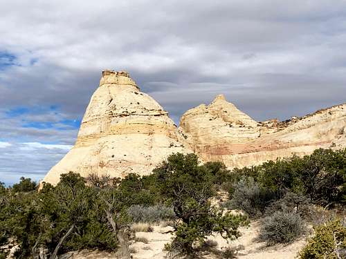 Toviah Tower
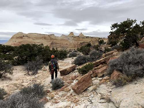 Approach to Toviah Tower - can you Toviah and Nemo towers peeking in the distance, keep bypassing the cliffs ahead of you on its south side.
 Toviah Tower is a very scenic tower located in San Rafael Swell, near Interstate 70. It is located near Eagle Canyon. The summit requires technical climbing rated as 5.8+R. It does involve mostly slab climbing and it is run out. Most desert towers require crack climbing, but here the crux are exposed run out slabs. The tower can be hard to find. I hope my description and gaia recording will help you to find this beauty.
Toviah Tower is located within Sids Mountain Wildernesss Study Area (northwest portion of the San Rafael Swell), and is named after one of the areas earliest ranchers, Sid Swasey.
The San Rafael Swell encompasses 2,000 square miles of public land, is known for its scenic sandstone formations, deep canyons, and expansive panoramas. Seven Wilderness Study Areas are located here.
Getting There
From Green River drive about 40 miles west on Interstate 70. Exit an unmarked exit just past mile marker 121. There is a paved road leading to a highway maintenance building. Follow this road until its end (there is a turn off for Eagle Canyon, dirt road before the road leads to a parking lot by the large maintenance structure). Continue on the paved road and across from parking lot by the building there is a small dirt road. Take this dirt road to its end, only a short distance and park at the small parking lot.
Head west from here, at some point you will see a small arch if you look back. We found a few cairns here and started to follow those. There was even a trail at some sections. After a while you will be able to see tops of 2 towers: Nemo and Toviah. You will have to bypass some cliffs and depressions to reach the base of Toviah Tower. The approach takes 40 min? The long time on gaia application includes also rest, climbing, time on the summit etc.
We followed directions on Mountain Project and initially it appeared a little confusing. However, we found the tower and I recorded our approach on Gaia application. There was a little trail on and off and some cairns. The area is very scenic.
Route
 Toviah Tower
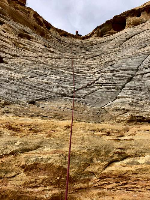 Toviah Tower
The route starts from the start of the gully that separates Toviah Tower from Nemo by a large dead tree.
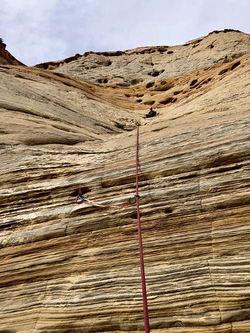
Pitch 1: Start right of the large dead tree. Trend left above the dead tree, there is some trad protection, but climbing is mostly on slabs. Traverse on the flatter terrain to an open groove - there used to be drilled angle piton here, but no more. This section is scary and not really protected. A fall here could be a ground fall and very serious. We found an open hole taking red Camalot #1. Go up the steep grove, just a few moves, some holds are fragile. The climbing eases up and you reach anchors. 190 feet, 5.7+
Pitch 2: Start left to a bolt (easily seen from the anchors) about 20 feet above the anchor, then continue more left to another bolt in the gray band of rock and higher up another bolt. The top gets steeper. Protection: 3 bolts. Length: 160 feet. 5.8+
Pitch 3: 3rd and 4th class moves up the wide ridge until it steepens just below the main summit.
Pitch 4: Move right along a narrow ledge, up towards a bush in a groove, slabs on the left and head for a short chimney. 60 feet, 5.4.
Descent: Rappel the route. You need two 60 meter ropes to rappel. Total of 3 rappels. There are rappel anchors set up. You may need to replace webbing at some of the stations.
Red Tape
Hiking, climbing are free. The issue we found is that we followed instructions on Mountain Project and there was nothing about restricted access, however the paved road near the highway maintenance structure has a sign that entry is allowed only to authorized vehicles. We tried to drive on Eagle Canyon Road, but this was going away from out destination and since our only description was Mountain Project, we trespassed on the road and moved quickly onto that smaller dirt road with a small parking lot. Mountain Project also mentions you can camp here, but I would not recommend that.
Try to avoid cryptobiotic soil on your approach.
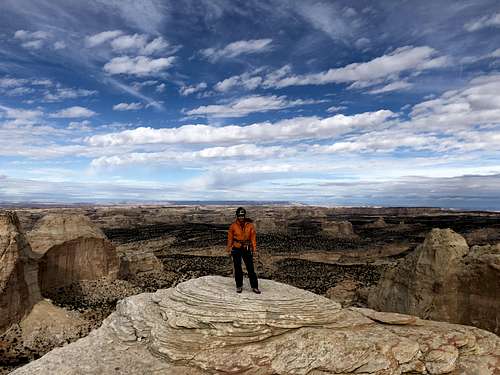 Summit of Toviah Tower
When to Climb
Spring and autumn are probably the best seasons, summers can be very hot, so start early and bring plenty of water. Winter can be nice as well.
Camping
Mountain Project says that you can sleep at the trailhead, but as mentioned above technically you have to trespass on a road to get there. I would recommend other sites in San Rafael Swell, basically any dirt. I did not explore Eagle Canyon Road far, but possibly there could be some primitive sites.
External Links
ZeeJay - Nov 11, 2018 6:22 am - Voted 10/10
WaypointYour waypoint is a little off. N38.87616 W110.86215 puts you in the flattish area SSE of the tower. A better waypoint is N38.87897 W110.8643.
Liba Kopeckova - Nov 11, 2018 5:13 pm - Hasn't voted
Re: Waypointthanks.