
-
 5853 Hits
-
 87.66% Score
-
 25 Votes
|
|
Mountain/Rock |
|---|---|
|
|
28.12831°N / 17.15519°W |
|
|
Hiking, Scrambling |
|
|
Spring, Summer, Fall, Winter |
|
|
2415 ft / 736 m |
|
|
Overview
 Altos de Uteza Altos de Uteza |
One of the first mountains you see, when you arrive at the port of San Sebastian de La Gomera, is a mountain consisting of several highpoints, the Altos de Uteza. It is located to the north-west of the town on a ridge, which separates the profound Barranco de las Layas in the south from Barranco de Majona in the north. The ridge is a typical leftover of La Gomeran volcanic activity which stopped already about two million years ago. Wind and weather have eroded deep canyons into the soft volcanic earth leaving only the tougher materials, mainly basalt, largely untouched.
 |  |  |
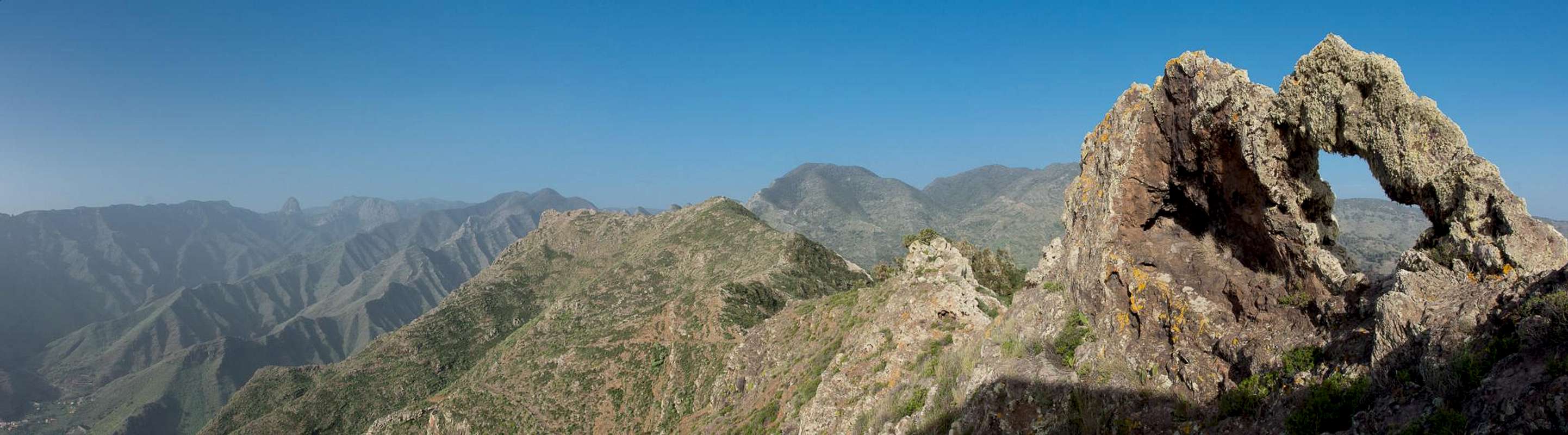
The Altos are a set of half a dozen basalt summits sticking out of a brittle tuff, pumice and lava hillock, beautiful in their striking colours, especially on a beautiful cloudless day. While the ridge can be obtained easily (there is a road leading from one barranco to the other) the summits are reserved for those who dare to climb loose and brittle overgrown rock. There are lots of caves on both sides of the mountain, additionally a rock window, all bearing witness of the erosive activity of the millenia.
 |  |  |
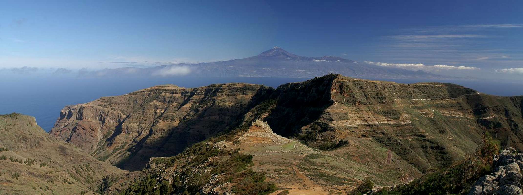
On the summits you are rewarded with absolutely stunning views. To the east the island of Tenerife hovers just above the top of neighbouring Montaña Ismael, to the south there is the long stretched Lomo de la Cruz, culminating in the three volcanic plugs of Roque de Agando, Roque de la Zarcita and Roque Ojia and to the west the overgrown Cumbre Carbonara looms. And since the summits are off limits to regular hikers you will have these views to enjoy for yourselves.
The 360° summit panorama
  |
Getting There
 |
In contrast to the large Canary Islands, La Gomera and El Hierro don't have international airports. Reaching the islands therefore means switching to a local carrier at Tenerife (or any of the other Canary Islands) or use a ferry. Since weather is known to be unstable at La Gomera Airport near Playa de Santiago, most travel offices will offer the ferry option.
Usually you will be able to book a flight to Tenerife South together with a bus transfer to the harbour at Los Christianos and the ferry to San Sebastian de La Gomera (bus transfer to your hotel on La Gomera is also included). If you want to travel on your own you can use ferries from either La Palma or Los Christianos and Santa Cruz on Tenerife.
The mountain - Altos de Uteza - is located north of TF711, the road which connects San Sebastian de La Gomera with Hermigua. The trailhead is at km 8, right before the first of the tunnels through the Cumbre Carbonara Range.
Red Tape
 Gallotia galloti gomerae
 The Altos de Uteza are just inside the Parque Natural de Majona. La Gomera has a lot of National, Regional, Local and Natural parks, basically sparing only the habitated areas. The Parque Natural de Majona is one of these and the usual restrictions apply. Don't leave roads or trails, take your refuse with you and don't disturb wild animals. Leave plants in their place. The area is used for sheep grazing and on neighbouring Montaña Ismael there is a shepherd's cottage with a lot of waste strewn around. The Altos de Uteza are quite clean and should remain that way.
There are no climbing restrictions when scrambling to one of the Altos, the summits. Take care since the volcanic rock is rather rotten and breaks off easily.
Accommodation
 |
Of course you can find a lot of hotels, fincas and casas on the island which you can book from any travel office. The nearest town is San Sebastian de La Gomera, the island capital. Also, Hermigua is only a few kilometres away, but on a very winding road. Both San Sebastian and Hermigua are not the typical tourist destinations, which you rather find on the south coast.
Weather Conditions
There are few sites on the web, which deal with the weather for La Gomera. The island just is not very popular with the tourist crowd. The ones you can find are for San Sebastian, which is rather close to the Altos de Uteza. The following table gives a rough general overview over the weather on La Gomera, at sea level.| Month | Jan | Feb | Mar | Apr | May | Jun | Jul | Aug | Sep | Oct | Nov | Dec |
| Avg. day temp.[°C / °F] | 20 / 68 | 20 / 68 | 21 / 70 | 22 / 72 | 23 / 73 | 25 / 77 | 27 / 81 | 29 / 84 | 27 / 81 | 25 / 77 | 23 / 73 | 21 / 70 |
| Avg. night temp.[°C / °F] | 15 / 59 | 15 / 59 | 15 / 59 | 16 / 61 | 16 / 61 | 18 / 64 | 20 / 68 | 22 / 72 | 21 / 70 | 20 / 68 | 17 / 63 | 17 / 63 |
| Water temp.[°C / °F] | 19 / 66 | 19 / 66 | 19 / 66 | 19 / 66 | 20 / 68 | 21 / 70 | 22 / 72 | 23 / 73 | 23 / 73 | 22 / 72 | 22 / 72 | 21 / 70 |
| Rainy days | 11 | 8 | 6 | 5 | 2 | 1 | 0 | 1 | 2 | 6 | 8 | 8 |
The Canary Islands (as well as Madeira) are located in the trade wind zone. You almost always encounter northeastern winds which carry a lot of humid air. Being forced to climb to higher altitudes this moisture condenses into clouds. This in return means that most of the time the northeastern part of the islands is covered in clouds from altitudes of 1000m through 1500m.
The mountainous region in the centre of the island is of the same alltitude and thus stops the clouds. While the northern parts of the islands can be foggy and rainy the southern parts most often are sunny and hot. On La Gomera the centre of the island collects almost all moisture in a big cloud forest, the laurisilva. It is the largest consecutive cloud forest on any of the Canary Islands and has been declared world heritage site.
Maps & Books
Out of the multitude of maps and books I have been using the following. However, so far I have not found a good hiking map of the island. The one posted here is ok but shows only a fraction of the marked hiking trails.- Maps
- La Gomera
Kompass Map WK231
Kompass Verlag
ISBN: 978-3-85491-015-2
Books
- La Gomera
Klaus Wolfsperger / Annette Miehle-Wolfsperger
Rother Verlag
ISBN 978-3-7633-4007-1 (German)
ISBN 978-3-7633-4823-7 (English)
ISBN 978-3-7633-4707-0 (Spanish)