
-
 7961 Hits
-
 83.69% Score
-
 17 Votes
|
|
Mountain/Rock |
|---|---|
|
|
28.11739°N / 17.33556°W |
|
|
Hiking, Scrambling |
|
|
Spring, Summer, Fall, Winter |
|
|
2805 ft / 855 m |
|
|
Overview
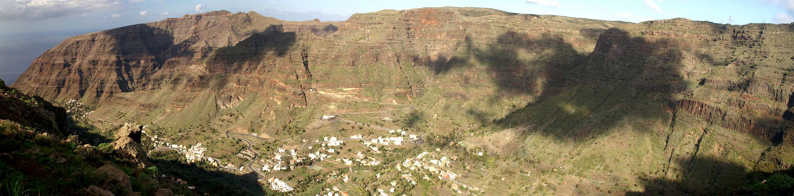
 La Merica above the villages of Valle Gran Rey as seen from Degollada de Cerrillal La Merica above the villages of Valle Gran Rey as seen from Degollada de Cerrillal |
Valle Gran Rey, or simply "the Valle" with its half dozen beaches is the touristic centre on the island of La Gomera. Though there still are no huge hotell complexes in the area you still can find a lot of tourists in the area. But apart from the beaches the Valley is known for its hiking and climbing possibilities, paths and trails leading through narrow canyon-like barrancos through near-vertical volcanic rock faces or across exposed ledges hundreds of metres above the valley floor.
The Valley is surrounded by huge mesas on three sides, mesas, which tower up to 800m above the sea and up to 600m above the floor. And since they are only separated by a distance of about 3km, Valle Gran Rey appears to be a closed area, nnot reachable from any side. And in fact, when the Spaniards conquered the island in the 16th century for centuries the valley remained in the hands of the original inhabitants, the Guanches.
To the west of the Valley, separating it from the western shore of the island, the highest of the mesas spings up to the sky. La Merica it is called, 855m high, seemingly unapproachable when you look up from the beaches underneath. However, an old 17th century camino heads up from the south-west of the mesa to its top, running along dozens of switchbacks before reaching the high plateau high above. It certainly is one of the most scenic and panoramic caminos on the island offering ever changing views with each turn. On fine days the islands El Hierro and La Palma are visible to the south-west and north-west, the mesas on the other side of the valley, Las Pilas and Tequergenche offer a perfect frame for the view to La Fortaleza de Chipude and Garajonay, the highpoint of the island.
To the north, La Merica drops off with a severe north face into Barranco de Taguluchs, again 600m underneath the mesa. An unmarked trail heads up from the village of Taguluche through the many north face towers, reaching the high-plateau from its north-west. The climb is tricky and exposed and very challenging thanks to the horrible quality of the rock in most of the sections. Many a scree slope bears witness of the many rockfalls the Merica north face witnesses.
Astonishingly, La Merica is rather popular among hikers. Moost of them start from Mirador Ermita del Santo near Arure and hike the remaining 50m of elevation gain along a 2km long dirt road, using the camino in the south to descend to Valle Gran Rey. The top of the mesa is a broad backed high plateau, often swept by fierce winds. There are two routes across it, one on either side of the mesa, the eastern one being far more popular. At the southern end, beneath a little pine tree, you find a wonderful lookout spot, seemingly towering vertically above the beaches on the south-western shore of the island. It is famous for its sunsets in winter, which occur right behind the island El Hierro in this season.
|


Getting There
 Beneath the La Merica summit
In contrast to the large Canarian Islands, La Gomera and El Hierro don't have international airports. Reaching the islands therefore means switching to a local carrier at Tenerife (or any of the other Canarian islands) or use a ferry. Since weather is known to be unstable at the La Gomeran airport near Playa de Santiago, most travel offices will offer the ferry option.
Usually you will be able to book a flight to Tenerife South together with a bus transfer to the harbour at Los Christianos and the ferry to San Sebastian de La Gomera (bus transfer to your hotel on La Gomera is also included).If you want to travel on your own you can use ferries from either La Palma or Los Christianos and Santa Cruz on Tenerife.
There are several trailheads for the climb of La Merica. The shortest "ascent route" starts from Arure, a village above the end of Valle Gran Rey. You can also start from Calera near the shore at the mouth of the valley or - the most interesting ascent - at Taguluche to the north of the mesa.
You reach the trailheads from San Sebastian de La Gomera via TF713, the Carretera del Centro, which connects San Sebastian with Valle Gran Rey. After passing the island's highpoint, Garajonay, you reach a three way intersection: the left road runs down to Valle Gran Rey, the right one leads to Vallehermoso. For the Arure and Calera trailheads take the Valle Gran Rey road. After 4km it leads you through the village of Arure. At a sharp left turn a side road turns off to the Mirador Ermita del Santo, the Arure trailhead. If you follow the road down into Valle Gran Rey, near its end you will come to a roundabout to the right of which there is a filling station, to the left a big bus stop. Here is the Calera trailhead for La Merica.
For the Taguluche trailhead follow the Vallehermoso road for a couple of turns. At a panoramic intersection (restaurant Chorros de Epinos to the left) a road turns off to Ajolera, Tazo and Taguluche. Follow the signs to Taguluche. They will take you across a saddle between Lomo de Carreton and the wild Techeleche Range before descending to Taguluch. A good parking possibility is near the Ermita de San Sallvador at the top of the village, the trailhead is near the end of the village, close to the end of the road.
Red Tape
 Alium blossom
La Merica is part of the Parque Rural de Valle Gran Rey. There are not many regulations apart from not leaving trails. However La Merica is a flat topped broad Mesa, which formerly was used for farming. There are still signs of that past like the ruins of farmhouses, threshing places, cattle pens etc. giving the top of the Mesa the aspect of farmed fields. The slopes and walls to the sides, however, are very different with sometimes very brittle rock. Venturing into the steep canyon-like barrancos is not only forbidden, it also is very dangerous.
Accommodation
  |
Of course you can find a lot of hotels, fincas and casas on the island which you can book from any travel office. At Taguluche and Arure you may find an inn or two for overnight accommodation, down in Valle Gran Rey you can everything. As far as I know there are no campgrounds and camping on the beaches is not allowed. One exception might be Playa de las Arenas, which thanks to its history of German Hippies seems to follow its own rules.
Weather Conditions
 Rainbow above Cuesta del Barro and La Merica
There are few sites on the web, which deal with the weather for La Gomera. The island just is not very popular with the tourist crowd. The ones you can find are for San Sebastian, which is located on the other side of the island. Generally Valle Gran Rey and its surroundings are pretty weatherproof with sunny days when the rest of the island lies under a thick cloud cover. However the top of La Merica is exposed to all kind of winds, which can be very fierce on the Canarias.
The following table gives a rough general overview over the weather on La Gomera, at sea level.
| Month | Jan | Feb | Mar | Apr | May | Jun | Jul | Aug | Sep | Oct | Nov | Dec |
| Avg. day temp.[°C / °F] | 20 / 68 | 20 / 68 | 21 / 70 | 22 / 72 | 23 / 73 | 25 / 77 | 27 / 81 | 29 / 84 | 27 / 81 | 25 / 77 | 23 / 73 | 21 / 70 |
| Avg. night temp.[°C / °F] | 15 / 59 | 15 / 59 | 15 / 59 | 16 / 61 | 16 / 61 | 18 / 64 | 20 / 68 | 22 / 72 | 21 / 70 | 20 / 68 | 17 / 63 | 17 / 63 |
| Water temp.[°C / °F] | 19 / 66 | 19 / 66 | 19 / 66 | 19 / 66 | 20 / 68 | 21 / 70 | 22 / 72 | 23 / 73 | 23 / 73 | 22 / 72 | 22 / 72 | 21 / 70 |
| Rainy days | 11 | 8 | 6 | 5 | 2 | 1 | 0 | 1 | 2 | 6 | 8 | 8 |
The Canarian Islands (as well as Madeira) are located in the trade wind zone. You almost always encounter northeastern winds which carry a lot of humid air. Being forced to climb to higher altitudes this moisture condenses into clouds. This in return means that most of the time the northeastern part of the islands is covered in clouds from altitudes of 1000m through 1500m.
The mountainous region in the centre of the island is of the same alltitude and thus stops the clouds. While the northern parts of the islands can be foggy and rainy the southern parts most often are sunny and hot. On La Gomera the centre of the island collects almost all moisture in a big cloud forest, the laurisilva. It is the largest consecutive cloud forest on any of the Canarian islands and has been declared world heritage site.
Maps & Books
Out of the multitude of maps and books I have been using the following. However, so far I have not found a good hiking map of the island. The one posted here is ok but shows only a fraction of the marked hiking trails.- Maps
- La Gomera
Kompass Map WK231
Kompass Verlag
ISBN: 978-3-85491-015-2
Books
- La Gomera
Klaus Wolfsperger / Annette Miehle-Wolfsperger
Rother Verlag
ISBN 3-7633-4007-6 (German)
ISBN 3-7633-4823-9 (English)