
-
 7801 Hits
-
 82.48% Score
-
 15 Votes
|
|
Mountain/Rock |
|---|---|
|
|
28.17951°N / 17.19965°W |
|
|
Hiking |
|
|
Spring, Summer, Fall, Winter |
|
|
2917 ft / 889 m |
|
|
Overview
 Lomo Gordo as seen from the east Lomo Gordo as seen from the east |
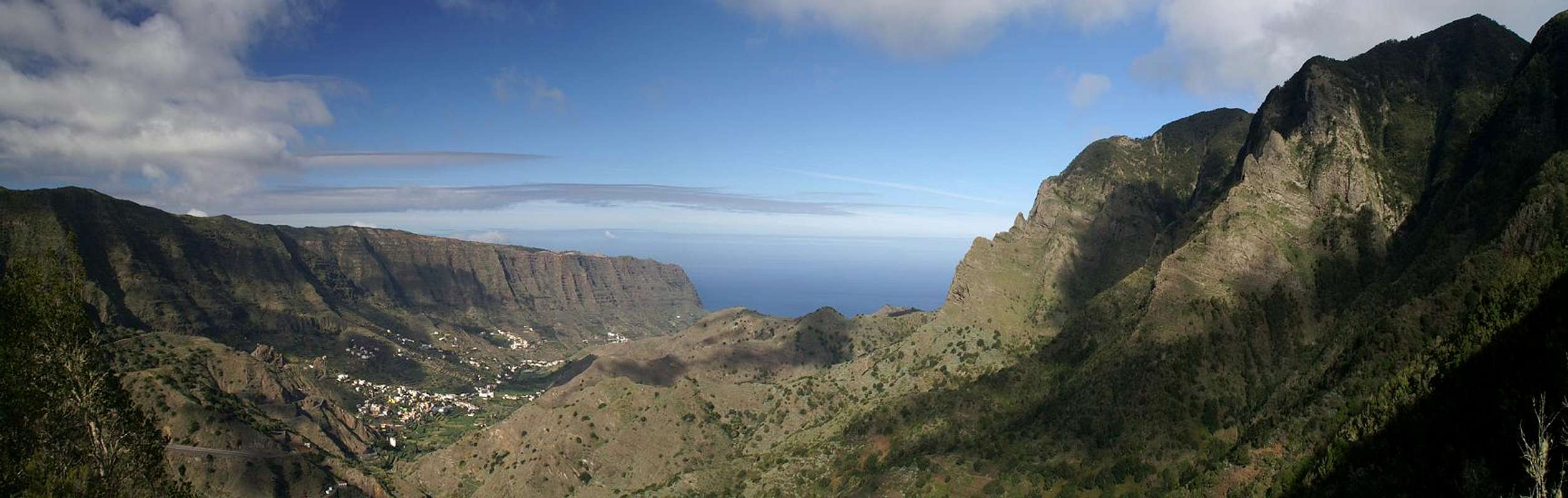
The island of La Gomera defines itself rather by its valleys and canyons than by its mountains. From the central highland around the highpoint Garajonay more than 50 of these barrancos run towards the sea. While in the south of the islands you find narrow canyon-like barrancos the ones in the (geologically) older north are often wide valleys. All are separated by mesas - flat on their top but with very steep slopes where they drop off towards either valleys or the sea. Especially in the north - where erosion has formed wide valleys the remaining mesas become very narrow and thus offer wonderful hiking possibilities.
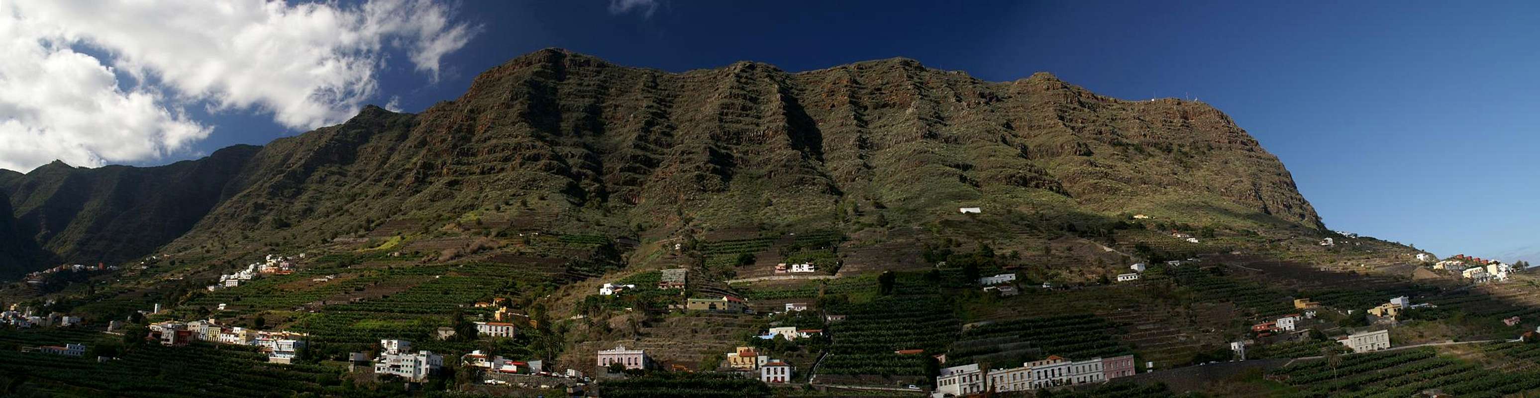
One of these mesas, the ridge which separates Barranco de Monteforte, the valley of Hermigua, from Barranco Sobre Agulo, the high valley of Agulo, is famous for its stunning hiking routes. It is called Lomo Gordo and stretches for about 4km from its highpoint, Alto de Atallaya, to the mirrador of Risquete, 553m directly above the sea. Two wonderful routes lead up to the plateau on its top, both following ancient caminos, mule trails which have connected Hermigua, La Palmita and Agulo for the better part of the last four centuries. The eastern one of these routes follows a spur which directly starts above the town of Hermigua and ends at the plateau on top. The camino winds its way along natural ledges, almost always using the steepest parts of the spur.
The second (western) route starts at Agulo on the north coast and heads through the "red wall", a vertical tuff-and-basalt wall directly above the town. It also is incredibly steep and offers what amounts to the most perfect views you can have anywhere on La Gomera: seen from the red wall Spain's highest mountain, Teide on Tenerife, appears to hover above the beautiful town of Agulo. The remainder of the route is far less spectacular and reaches the Lomo Gordo plateau from the west.
Both routes combine high on the rather narrow plateau, which itself displays colourful erosion structures. There are several shallow highpoints from which you also can take in wonderful Tenerife views. The downside is that a dirt road leads onto LLomo Gordo from the centre of the island passing the hamlets of El Cedro and Los Acevinos on its way. Therefore quite often the plateau can appear a little crowded.
|


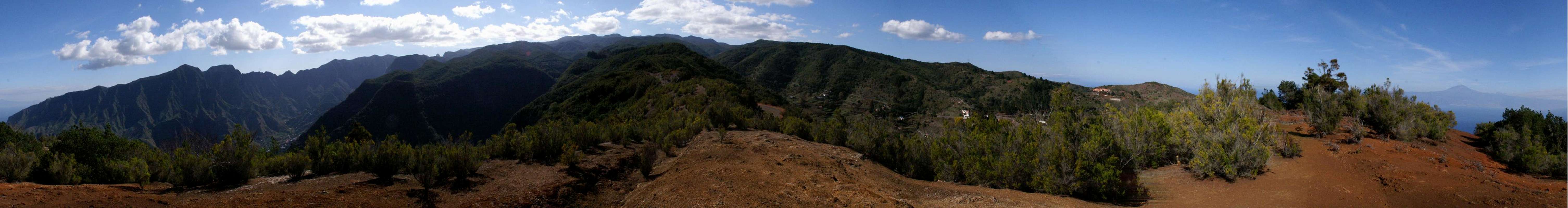
360° panorama
  |
Getting There
 |
In contrast to the large Canarian Islands, La Gomera and El Hierro don't have international airports. Reaching the islands therefore means switching to a local carrier at Tenerife (or any of the other Canarian islands) or use a ferry. Since weather is known to be unstable at the La Gomeran airport near Playa de Santiago, most travel offices will offer the ferry option.
Usually you will be able to book a flight to Tenerife South together with a bus transfer to the harbour at Los Christianos and the ferry to San Sebastian de La Gomera (bus transfer to your hotel on La Gomera is also included). If you want to travel on your own you can use ferries from either La Palma or Los Christianos and Santa Cruz on Tenerife.
To reach the trailheads at Hermigua or Agulo simply follow the Carretera del Norte, TF-711, from San Sebastian de La Gomera. It reaches Barranco de Monteforte through a tunnel and heads north for Hermigua. The Hermigua trailhead is near the church and there is ample parking space along the main road.
For Agulo, simply follow TF-711 for another 4km. The road passes the town in its south and the winds up the slopes beneath the red wall in two switchbacks. There is parking space along the road right beneath the switchbacks and a marked path leads towards the trailhead right under the red wall.
Red Tape
 Chalcides viridanus on Lomo Gordo
There is no red tape on Lomo Gordo or its slopes. The mesa doesn't belong to any of the many parks of the island and is not used agriculturally. On its slopes, however, you will find the garden and field terrasses of Ibo Alfaro (east) and El Revolcadero (west) which are privately owned. Please respect private property.
Accommodation
 |
Of course you can find a lot of hotels, fincas and casas on the island which you can book from any travel office. Most of them will be in the south of the island and there are only a few ones available at the nearest towns, Hermigua and Agulo. The closest tourist location probably is the island capital San Sebastian, 40km to the east.
Weather Conditions
There are few sites on the web, which deal with the weather for La Gomera. The island just is not very popular with the tourist crowd. The ones you can find are for San Sebastian, 40km to the east of Lomo Gordo. The following table gives a rough general overview over the weather on La Gomera, at sea level.| Month | Jan | Feb | Mar | Apr | May | Jun | Jul | Aug | Sep | Oct | Nov | Dec |
| Avg. day temp.[°C / °F] | 20 / 68 | 20 / 68 | 21 / 70 | 22 / 72 | 23 / 73 | 25 / 77 | 27 / 81 | 29 / 84 | 27 / 81 | 25 / 77 | 23 / 73 | 21 / 70 |
| Avg. night temp.[°C / °F] | 15 / 59 | 15 / 59 | 15 / 59 | 16 / 61 | 16 / 61 | 18 / 64 | 20 / 68 | 22 / 72 | 21 / 70 | 20 / 68 | 17 / 63 | 17 / 63 |
| Water temp.[°C / °F] | 19 / 66 | 19 / 66 | 19 / 66 | 19 / 66 | 20 / 68 | 21 / 70 | 22 / 72 | 23 / 73 | 23 / 73 | 22 / 72 | 22 / 72 | 21 / 70 |
| Rainy days | 11 | 8 | 6 | 5 | 2 | 1 | 0 | 1 | 2 | 6 | 8 | 8 |
The Canarian Islands (as well as Madeira) are located in the trade wind zone. You almost always encounter northeastern winds which carry a lot of humid air. Being forced to climb to higher altitudes this moisture condenses into clouds. This in return means that most of the time the northeastern part of the islands is covered in clouds from altitudes of 1000m through 1500m.
The mountainous region in the centre of the island is of the same alltitude and thus stops the clouds. While the northern parts of the islands can be foggy and rainy the southern parts most often are sunny and hot. On La Gomera the centre of the island collects almost all moisture in a big cloud forest, the laurisilva. It is the largest consecutive cloud forest on any of the Canarian islands and has been declared world heritage site.
Maps & Books
Out of the multitude of maps and books I have been using the following. However, so far I have not found a good hiking map of the island. The one posted here is ok but shows only a fraction of the marked hiking trails.- Maps
- La Gomera
Kompass Map WK231
Kompass Verlag
ISBN: 978-3-85491-015-2
Books
- La Gomera
Klaus Wolfsperger / Annette Miehle-Wolfsperger
Rother Verlag
ISBN 3-7633-4007-6 (German)
ISBN 3-7633-4823-9 (English)