
-
 12238 Hits
-
 84.27% Score
-
 18 Votes
|
|
Mountain/Rock |
|---|---|
|
|
28.10030°N / 17.27643°W |
|
|
Hiking, Scrambling |
|
|
4072 ft / 1241 m |
|
|
Overview
 La Fortaleza as seen from La Merica La Fortaleza as seen from La Merica |
On the island of La Gomera there are no objects of mountaineering interest - with one exception. Granted - there are the volcanic plugs of Los Roques, which might be interesting climbing destinations, but climbing is not allowed anymore after the Monumento Natural de Los Roques has been established. There are Mesas like Tequergenche, La Merica or Lomo Gordo, which are quite difficult to get to, but they are only difficult from a hiker's point of view. There is a highpoint, Garajonay, which is rather a hill than a mountain and a dirt road leads almost to its top.
Yet, there is that exception, a table-top mountain named La Fortaleza, towering above the hamlet of Chipude , just south of the Parque Nacional de Garajonay. La Fortaleza - like it name already indicates - a veritable fortress, made up from beautiful red basalt. Like befits any fortress there are bastions and forecastles, the most formidable ones in its south-east and north-east. La Fortaleza stands out among the mesas of southern La Gomera as an impressive landmark - visible from almost everywhere and consequently also a good lookout platform in itself.
Generally La Fortaleza resembles a lot another Canarian table-top mountain, Sombrero de Chasna on Tenerife. However, while the Sombrero rises out of the shallow south slopes of the Cañadas del Teide, La Fortaleza really towers above everything. It is located on top of one of the typical Gomeran mesas which separate deep canyon-like barrancos. These Barrancos evolved over the ages, when the soft Gomerann soil (mainly lava and cinder) got washed away to the sea. The more solid areas remained standing, forming the mesas. In the case of La Fortalleza the rock is top quality basalt, created during La Gomera's volcanic phase when fissures or funnels solidified.
 Fortaleza east face with break-off zone
In its beginnings La Fortaleza was a circular table-top mountain, but due to the erosion of Barranco del Erque, one of the main water drainages in the south of the island, the east of the mountain toppled into the profound canyon, leaving a vertical (even slightly overhanging) tall east face. Today this east face is the main attraction of the mountain but you have to venture out on the very exposed south-east buttress to be able to get a decent glimpse of it. Climbing the face is not allowed, ever since the mountain has been declared natural monument.
Thus, there is only one route to the plateau on top, a route which climbs a couloir towards the top of the north-east buttress. Formerly the route might have been moderately difficult but ever since steps have been cut and built to reach the base of the mountain only the couloir itself remains a bit tricky. Also, once on top of the buttress a short exposed traverse leads to the Fortaleza plateau, ensuring that only experienced hikers make it to the top.
Guidebooks will tell you that La Fortaleza was a sacred place to the pre-Hispanic inhabitants of La Gomera, the Guanches. On the plateau you can find several sanctuaries of sacrificial altars, however you have to search carefully. I didn't find any indication of these but I didn't look for them either.
|


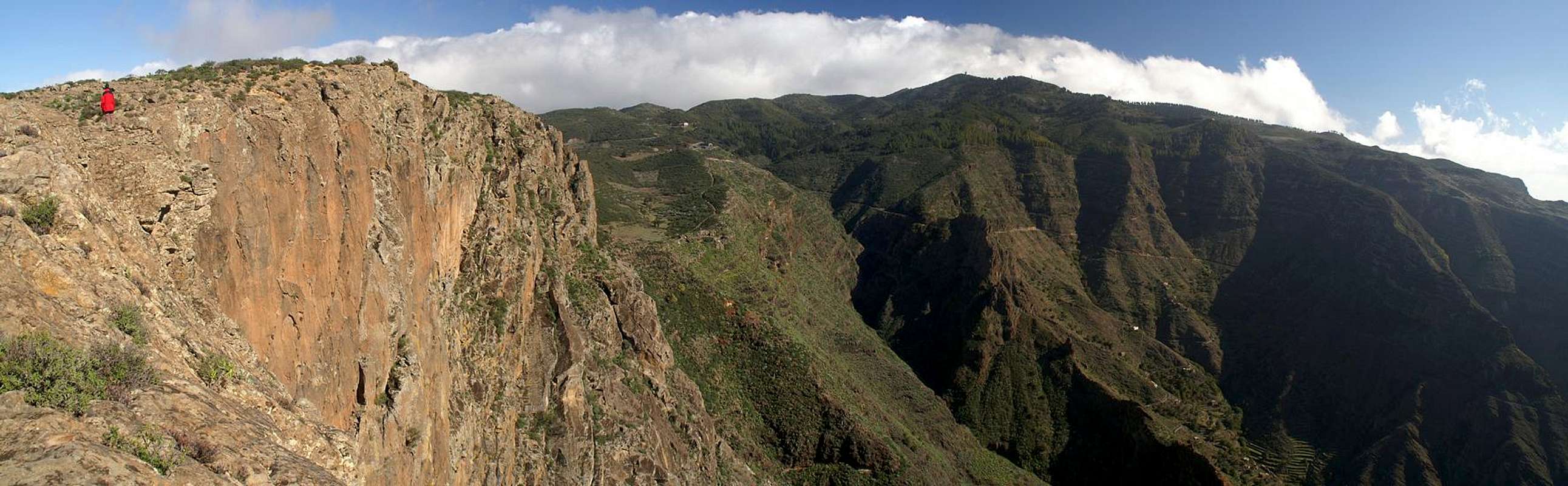
Panoramic View
  |
Getting There
 Threshing place on La Merica with Garajonay and Fortaleza behind
In contrast to the large Canarian Islands, La Gomera and El Hierro don't have international airports. Reaching the islands therefore means switching to a local carrier at Tenerife (or any of the other Canarian islands) or use a ferry. Since weather is known to be unstable at the La Gomeran airport near Playa de Santiago, most travel offices will offer the ferry option.
Usually you will be able to book a flight to Tenerife South together with a bus transfer to the harbour at Los Christianos and the ferry to San Sebastian de La Gomera (bus transfer to your hotel on La Gomera is also included).If you want to travel on your own you can use ferries from either La Palma or Los Christianos and Santa Cruz on Tenerife.
From San Sebastian follow TF-713, the Carretera del Centro leads to the mountains in the centre of the island. Just follow the signs to Valle Gran Rey, the most important touristic area in the south-west of La Gomera. Close to the island's highpoint, Garajonay, at a place (parking lot) called Pajarito a side roads turns off left (south) to the village of Igualero. The road winds through the Laurisilva Forest before reaching a spot on the ridge above Barranco del Erque where you can park your car in a small three car parking lot. If the places are already taken, head on until you reach Chipude. There's another parking lot close to the church of the little village.
|


Red Tape
 |
La Fortaleza de Chipude and the surrounding area have been declared natural monument - Monumento Natural de la Fortaleza. Since then the regular rules for natural parks apply: don't leave trails, don't pluck flowers, don't stay overnight. The beautiful east face is off limits to climbing, though it looks very promising. Also, if you find any of the Guanche sanctuaries or artefacts, please leave them in place.
Accommodation
 La Fortaleza as seen across Barranco del Erque
Of course you can find a lot of hotels, fincas and casas on the island which you can book from any travel office. There are no close towns or villages, the closest ones are Chipude and Igualero to the west and north-east of the mountain. However, you won't find accommodation other than an inn there. Rather head for the tourist spots in Valle Gran Rey or Playa de Santiago. From Valle Gran Rey a very interesting hiking route (along an old 17th century camino) leads to Chipude.
Weather Conditions
There are few sites on the web, which deal with the weather for La Gomera. The island just is not very popular with the tourist crowd. The ones you can find are for San Sebastian, which is located half an island away to the east of the mountain. Temperatures at the coast are some 15 degrees lower than in the Laurisilva. With fog and high winds this difference can increase a lot. La Fortaleza is located to the south of the weather divide so that you generally will find much better weather here. Winds can still be a problem, since they don't find any obstacle on the almost barren Fortaleza plateau.The following table gives a rough general overview over the weather on La Gomera, at sea level.
| Month | Jan | Feb | Mar | Apr | May | Jun | Jul | Aug | Sep | Oct | Nov | Dec |
| Avg. day temp.[°C / °F] | 20 / 68 | 20 / 68 | 21 / 70 | 22 / 72 | 23 / 73 | 25 / 77 | 27 / 81 | 29 / 84 | 27 / 81 | 25 / 77 | 23 / 73 | 21 / 70 |
| Avg. night temp.[°C / °F] | 15 / 59 | 15 / 59 | 15 / 59 | 16 / 61 | 16 / 61 | 18 / 64 | 20 / 68 | 22 / 72 | 21 / 70 | 20 / 68 | 17 / 63 | 17 / 63 |
| Water temp.[°C / °F] | 19 / 66 | 19 / 66 | 19 / 66 | 19 / 66 | 20 / 68 | 21 / 70 | 22 / 72 | 23 / 73 | 23 / 73 | 22 / 72 | 22 / 72 | 21 / 70 |
| Rainy days | 11 | 8 | 6 | 5 | 2 | 1 | 0 | 1 | 2 | 6 | 8 | 8 |
The Canarian Islands (as well as Madeira) are located in the trade wind zone. You almost always encounter northeastern winds which carry a lot of humid air. Being forced to climb to higher altitudes this moisture condenses into clouds. This in return means that most of the time the northeastern part of the islands is covered in clouds from altitudes of 1000m through 1500m.
The mountainous region in the centre of the island is of the same alltitude and thus stops the clouds. While the northern parts of the islands can be foggy and rainy the southern parts most often are sunny and hot. On La Gomera the centre of the island collects almost all moisture in a big cloud forest, the laurisilva. It is the largest consecutive cloud forest on any of the Canarian islands and has been declared world heritage site.
Maps & Books
Out of the multitude of maps and books I have been using the following. However, so far I have not found a good hiking map of the island. The one posted here is ok but shows only a fraction of the marked hiking trails.- Maps
- La Gomera
Kompass Map WK231
Kompass Verlag
ISBN: 978-3-85491-015-2
Books
- La Gomera
Klaus Wolfsperger / Annette Miehle-Wolfsperger
Rother Verlag
ISBN 3-7633-4007-6 (German)
ISBN 3-7633-4823-9 (English)