
|
|
Mountain/Rock |
|---|---|
|
|
40.66920°N / 111.1292°W |
|
|
10234 ft / 3119 m |
|
|
Overview

Castle Peak from Castle Lake
The Uinta Mountains are one of the few mountain ranges in North America that run east to west rather than north to south. Within the Uinta Mountains are about 2000 lakes, and some 900-1000 are full of trout. Along with the San Juans in Colorado, the Uintas have more contiguous area above timberline than any other area in the Continental United States. This is a beautiful area with many lakes, meadows, wildflowers, and some rugged peaks. Solitude is usually easy to come by once you leave the popular fishing holes behind.
Castle Peak is not a high peak by Uinta Mountain standards. One good reason to climb the peak is that unlike most peaks in the Uinta Mountains, this one can be reached relatively easy in winter. There are excellent views from the summit.
Getting There

Castle Peak in winter
There are two main trailheads for the hike to the summit. The Yellowpine Trail is a longer hike. The Upper Setting/Castle Lake Trail is a shorter hike, but a longer drive, and includes driving on rough roads to reach the trailhead.
Yellow Pine Trailhead:
The trailhead is at a large signed parking lot that is located on the north side of Highway 150 6.5 miles east of Kamas. This trailhead is accessible year-round.
Upper Setting/Castle Lake Trailhead:
This trailhead is a little tricky to find. The route begins from the Upper Setting Road. This road is posted with a sign, and is located on the north side of the highway, 8.7 miles east of Kamas. The lower half of this un-paved road is suitable for passenger cars, but the upper half is suitable only to high clearance vehicles. This is the easiest way to find the trailhead: Follow the main road to it's end. There are many side tracks branching from the main road. Turn around at the end of the road, backtrack, and take the second 4wd track that branches from the north (right when backtracking) side of the main road. Drive (or walk) north along this track and take a left at a junction. This track heads west a short distance. Park at the vehicle barrier trench located next to a pond.
Routes Overview

NE Riddge of Castle
Yellow Pine Creek Route
This route has the most accessible trailhead. The route heads up the Yellow Pine Creek Trail to the saddle between the Box Canyon and Yellow Pine Creek drainages. From the saddle, the route follows the ridge west to the summit (no trail).
Edit: My last trip to Castle Peak was in 1997. I am told that the trails have changed since then.
There is now a trail to Castle Lake from Yellow Pine Lake. Apparently this trail is more used than the old one to the saddle between Yellow Pine Creek and Box Canyon and would make a shorter and easier route.
Upper Setting Route
This is the shortest route, but the road is rough to the trailhead. The route follows the trail to Castle Lake, then NW to the Box Canyon-Yellow Pine Creek saddle. The route then follows the ridge south to the summit.
Box Canyon Route
This is a beautiful route. Although maps show a trail up Box Canyon, it is totally faded away, and route-finding is required. This is a very scenic and seldom visited drainage. This cross country route heads south to the saddle between the Yellow Pine Creek and Box Canyon Drainages, and then follows the ridge south to the summit of Castle Peak.
Sketch Map-North Side
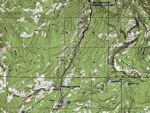
North side map-Castle Peak
Sketch Map-South Side
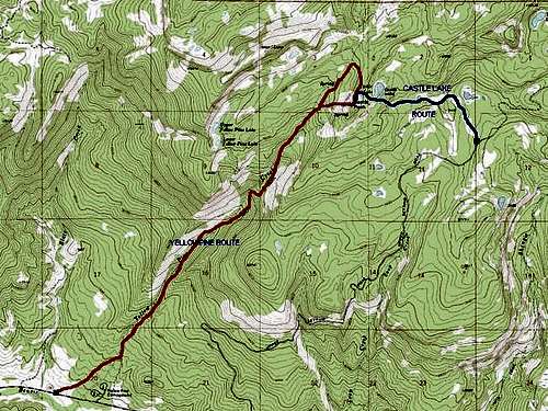
South side map-Castle Peak
Guidebook Available
More details about the area can be found in the book Western Uinta Backcountry Guide, including many routes to the summit, and hiking trails to the many lakes, and fishing information. Just send me a PM if you want to purchase the book.
SP members can have the book for 1/2 price, and there is no shipping cost.

Guidebook
Red Tape
A $3 access fee is charged for parking at any of the trailheads located off Highway 150.
When To Climb

Yellow Pine Lakes in August
The normal summer hiking season is from mid or late June until sometime in October. Late September-early October is beautiful with the fall colors.
The Upper Setting Road is open only during the above season, but you can ski or snow-shoe along the road.
Highway 150 is open year-round to the Yellowpine Trailhead, making winter access relatively easy. Castle Peak is perhaps the easiest peak in the Uinta Mountains to gain access to in the winter season.
Camping

Winter camping on Castle Peak
There are many campgrounds along Highway 150, but they can be crowded during summer weekends, especially around holidays.
Yellow Pine Creek Route
There are many backcountry campsites on the Yellow Pine Trail.
Upper Setting Route
There are many informal campsites along the Upper Setting Road. There are good campsites in the meadows to the north and south of Castle Lake. In winter, there are now several maintained yurts on the Upper Setting Road and around Castle Lake. Contact the ranger district for information.
Box Canyon Route
The upper and lower sections of the route have excellent and secluded campsite. The middle section of the route has only a few small and scattered campsites.
Mountain Conditions

Early winter near the Yellowpine TH
Contact the ranger station in Kamas for current road and trail conditions. Their phone number is 801-783-4338.
WEATHER FORECAST FOR WESTERN UINTA MOUNTAINS
Here are some average highs and lows from Mirror Lake at 10,190 feet :
| MONTH | HIGH | LOW |
| JAN | 23 | 0 |
| FEB | 25 | 2 |
| MAR | 29 | 6 |
| APR | 38 | 14 |
| MAY | 47 | 22 |
| JUN | 57 | 31 |
| JUL | 67 | 38 |
| AUG | 65 | 37 |
| SEP | 57 | 30 |
| OCT | 46 | 19 |
| NOV | 32 | 10 |
| DEC | 26 | 4 |