
-
 7062 Hits
-
 82.83% Score
-
 16 Votes
|
|
Mountain/Rock |
|---|---|
|
|
43.93750°N / 103.7415°W |
|
|
Pennington |
|
|
Hiking |
|
|
6940 ft / 2115 m |
|
|
Overview
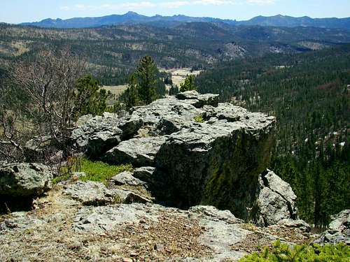 Summit View South
Copper Mountain, one of the highest summits in the Black Hills, is located in Pennington County, South Dakota. It rises over 600 feet above the Slate Creek valley at the northern foot of the mountain. However, according to Lists of John, Copper Mountain only has 200 feet of actual prominence and is unranked, due to the close proximity of 7,210-foot Odakota Mountain. The mountain has a small rocky southeast face that offers great views to the south. Harney Peak, Sylvan Peak, Medicine Mountain and Odakota Mountain can be clearly seen there. Heavy forest growth on the north side obscures much of the view of the valley below, and 7,164 foot Green Mountain to the northwest. Almost all the land on Copper Mountain is federal land and is managed by the Black Hills National Forest Service. Most of the forest on the mountain consists of Ponderosa pines and aspen. This mountain could be a rock collector’s paradise, with a wide variety of colorful rocks in various places. Long ago, gold and silver veins were found in the Copper Mountain area, though not in exceedingly large quantities like those that were found at the location of the Homestake Gold Mine in Lead, SD. Nevertheless, there was an operational mine on Copper Mountain at one time. What is left of the old Massif Mine is on the northeast slope of the mountain. Curiously, there is a “Copper Mountain Gravel Pit” about 1 mile west of the summit. However, it is not actually on Copper Mountain, but on the southern slope of an un-named 7,000-foot summit. There are no trails to the summit of Copper Mountain, but Six Mile Road winds around the eastern and southern slopes, offering hikers a variety of choices to create their own off-trail routes to the top. There is a mix of fallen timber, large rocks, underbrush and new tree growth that combines to slow hiking a bit. Because of the close proximity to Odakota Mountain and Green Mountain, a hiker can easily reach all three summits in one morning. If you want to make a 5-summit day of it, Hat Mountain and Medicine Mountain are not much further from Copper Mountain also.
Getting There
 Six Mile Road junction with Medicine Mountain Road
 Bobcat Road junction with Six Mile Road
Forest service maps will show several ways to reach this area, but perhaps the two most common approaches come from nearby Hill City and from Custer. From Custer, take Highway 385 four miles north to Road 297, turn west and follow that road about twelve miles to Six Mile Road. 297 becomes Medicine Mountain Road not far from Highway 385. Turn west on the Six Mile Road, where you will begin ascending the south side of Copper Mountain. To get to Six Mile Road from Hill City, take Road 317, Reno Gulch Road to Road 297. Turn north and follow 297 to Six Mile Road.
Route Options
The easiest route begins by parking along Six Mile Road by the junction with Bobcat Road (Road 299). There is an old logging road north of Six Mile Road that heads in a northeasterly direction. You can follow that for about .25-mile before it starts veering off to the north and away from the direction of the summit. From that point, an off-trail hike northeast to the summit is about .3-mile. The map below shows the easiest route to the summit. The elevation gain on this route will be about 200 feet.
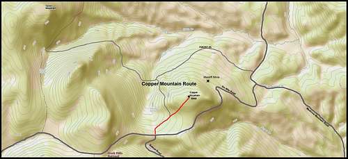 Copper Mountain Route Map
 The shortest bushwhack route
Of course, you can park further east along Six Mile Road and do a shorter bushwhack to the summit. The terrain for such an off-trail hike will be steeper and more rugged. Forest Service Road 297.3S winds around the northern base of Copper Mountain, from Medicine Mountain Road to the base of Green Mountain. This forest road could provide a base for bushwhacking up through the thick pine and aspen forest on the northern slopes.
Red Tape
This is on national forest land, so it is accessible year-around. Primitive camping is controlled by Black Hills National Forest Back Country Camping Regulations & Information. Illegal campfires will probably bring the quickest visits from diligent area forest rangers.
When to Climb
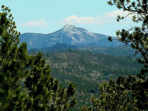
 Copper Mountain Northeast Side
Copper Mountain is in the area of the Black Hills that has some of the greatest snowfall and latest snow melt. Summer hail and electrical storms can be dangerous because of the altitude. For the latest weather forecast and conditions, click on the link below: Copper Mountain – Deerfield Area Weather Forecast & Conditions Copper Mountain is in a prime area for big game hunting. If you choose to hike during one of those seasons, be sure to wear plenty of orange. For more information on South Dakota hunting seasons, click on the link below: South Dakota Hunting Season Information
Camping & Lodging
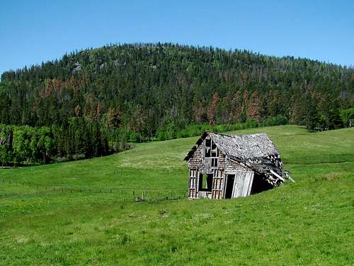 An old homestead near upper Slate Creek and Copper Mountain
Listed below are links to area campgrounds and lodging information sites:
National Forest Service Deerfield Campgrounds
Maps
Copper Mountain lies in the Medicine Mountain USGS Quad. Three useful maps for the area include The National Geographic Black Hills North map, The Black Hills National Forest map and the National Forest Service motor vehicle use map for the Mystic and Hell Canyon Ranger Districts. The third map is free at any forest service office in the Black Hills.
Forest Management Information
 A telephoto view of Harney Peak from the Copper Mountain summit
Mystic Ranger District
8221 South Hwy 16
Rapid City, SD 57702
Phone: (605) 343-1567 Fax: (605) 343-7134 Hours:
8:00 a.m. to 4:30 p.m., Monday - Friday
Custer Forest Service Office
1019 N. 5th Street
Custer, SD 57730
(605) 673-9200