
-
 9515 Hits
-
 81.54% Score
-
 14 Votes
|
|
Mountain/Rock |
|---|---|
|
|
43.71380°N / 103.706°W |
|
|
Custer |
|
|
Hiking |
|
|
5940 ft / 1811 m |
|
|
Overview
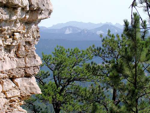 A view of Black Elk Peak from the summit of the south Twin Sister
Like a pair of Siamese twins, the Twin Sisters are two conjoined summits located about 8 miles southwest of Custer, South Dakota. The altitude, as well as latitude and longitude shown above, is only for the higher and more prominent north peak. The south peak altitude at the summit is 5,889 feet, the latitude is 43.7113 and the longitude is -103.7057. The north peak is officially ranked by Lists of John as # 59 in the Black Hills, with 400 feet of prominence. The peaks rise about 700 feet above Fourmile Creek, which flows a little over 1 mile east. These two peaks offer a fun hike with some great rock in their summit areas. From either summit, one can clearly see Harney Peak, Crazy Horse, Sylvan Peak, Cathedral Spires, Buckhorn Mountain, Mount Coolidge, and other summits. There is little evidence these peaks see many visitors, so be prepared to possibly have the peaks to yourself. A large slab of granite, called Castle Rock, lies about a mile north, offering rock climbers a workout. Also in the area, is Jewel Cave National Monument, about 7 miles west on Highway 16. There are some good hiking trails in Hell Canyon, both in and around Jewel Cave National Monument. The region around Twin Sisters has had many mines over the years. One of the more prominent mines, the Helen Beryl Mine, is at the eastern base of the peaks, and shows up on some topo maps. Like most of the mines in the area, the Helen Beryl Mine is mostly inactive because it is not currently economically practical to go after the deeper deposits of beryl, feldspar, and quartz there.
Getting There
 An important sign to watch for
 Some deadfall on the route
The best way to travel to Twin Sisters is by way of Highway 16 to Harry Mills Road, about 6 miles west of downtown Custer, South Dakota. At Harry Mills Road (Road 402 on forest service maps), go south 1 mile to Forest Service Road 402.1E. Go east on 402.1E about .9 mile, then turn right on Forest Service Road 402.1F. Follow that road for.4 mile to another junction. Once there, follow Road 715.3P south for about a half mile. Please note that these roads are mostly flat and not too rocky. While high clearance vehicles are always better on these back roads, a car could probably make this route, providing they watch for the occasional rock sticking up. Road 402.3P is rather narrow in places, so watch for enough space to pull over for safe and un-obstructive parking. In this general area, you will be on the east side of the saddle between Twin Sisters North and Twin Sisters South. A note on map discrepancies: The National Forest Service issues a fee Motor Vehicle Use Map for the Black Hills. For the most part, it is normally quite helpful. Here is one exception. Their map shows Road 402.1F as the road that is actually labeled “715.3P” (see photo). In reality, 402.1F goes around behind (west side) of Twin Sisters (which they label on their maps as “402.1D”. Additionally, Road 715.3P goes on further, intersecting several miles south with Road 715 (Pleasant Valley Road). Please be aware of this to avoid unnecessary extra travel.
Route
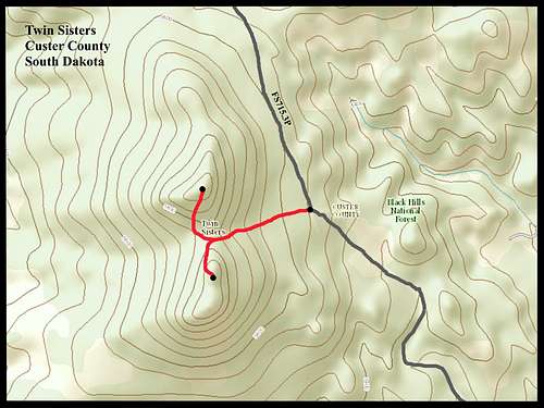 Twin Sisters Routes
There are no established trails on these peaks. As you ascend to either summit, the upper portions get somewhat steeper and both have a thick cover of pine needles. This makes footing a little slick at times. So, the best route seems to bushwhack up to the top of the saddle between the two peaks. The lower area below the saddle is more meadow-like, and also has the benefit of a little less deadfall. Once you are at the saddle, you will note some logging truck tracks up to the summit area of the north peak. This route pretty much sidesteps the pine needle problem. The south peak is rockier at the summit, so there are no logging truck tracks to follow. Line of sight will easily guide you, though. A diagram of the route from Forest Service Road 715.3P is shown above.
Red Tape
The only regulations for this area are the general regulations of the Black Hills National Forest. You can access those by clicking here: Black Hills National Forest Regulations These regulations also cover back country camping.
When to Climb
 South Sister view of North Sister
The peaks are on public lands, so are open to the public year-around. Since few hikers or climbers wish to venture out during lightning storms or blizzards, weather will likely be the first consideration. To check on the weather conditions and forecast for Twin Sisters, click here:
Twin Sisters – Custer Area Weather
South Dakota hunting seasons, particularly big game, may also be a concern. You can learn more about those seasons by clicking here:
Maps
Twin Sisters are in the USGS Fourmile Quad. Useful maps for the area include the National Geographic Black Hills South Map, as well as the free Motor Vehicle Use Map for the Black Hills (available at all area Forest Service offices).
Camping
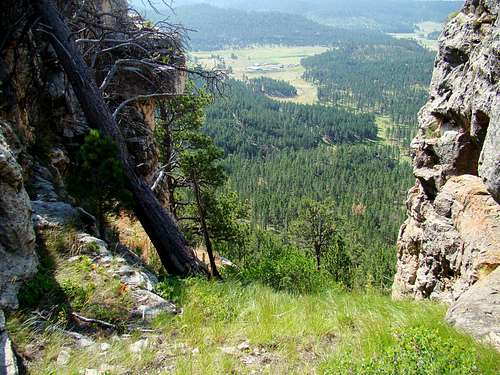 Summit view of Fourmile Creek valley
The nearest camping is at the Comanche Park Campground, located near the junction of Harry Mills Road & Highway 16 that you will pass as you follow the road route to the Twin Sisters. You can access that information at this link:
The nearby town of Custer offers a large selection of camping and lodging facilities. The Custer Chamber of Commerce maintains an up-to-date list of area facilities that you can access by clicking here:
Custer State Park also offers a wide variety of camping & lodging options. You can access their website by clicking here:
Custer State Park Camping & Lodging
You may also camp in the forest nearby, however be aware of the Black Hills National Forest Camping Regulations (see the link above in “Red Tape”).