
|
|
Mountain/Rock |
|---|---|
|
|
45.76477°N / 10.93722°E |
|
|
Trentino |
|
|
Hiking, Trad Climbing |
|
|
Spring, Summer, Fall, Winter |
|
|
4980 ft / 1518 m |
|
|
Overview
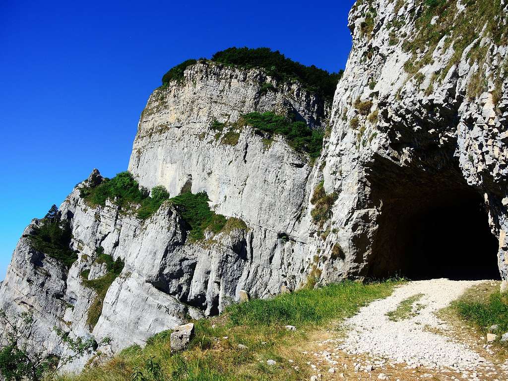
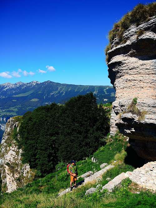
Corno della Paura 1518 m
The long chain formed by Monte Altissimo and Monte Baldo projects towards the Adige Valley (towards the East) an area of high and undulating mountain pastures moved by some elevations dropping down to the Adige Valley with steep rocky walls. One of these ones is Corno della Paura. On the other side (above La Polsa, the Trentino sector of Monte Baldo) the mountain slopes down with sweet and bucolic meadows towards La Polsa. From here there is a simple but surprising round trip taking place mainly along ex-military dirt roads on the ridge running between the stronghold of Monte Vignola and the stronghold of Corno della Paura, alternating marvelous prairies with rocky inlets in parts overlooking the Adige valley.
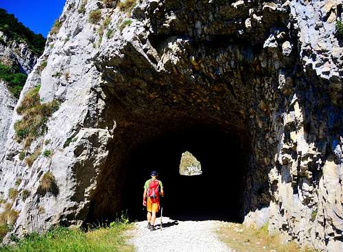
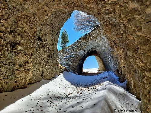
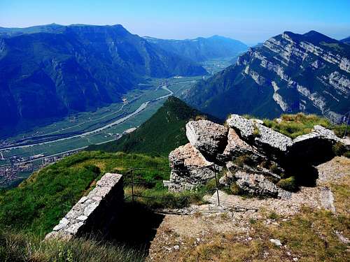
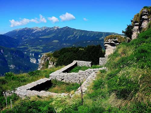
Extensive views, testimonies of the WWI war and a rich and interesting flora are the main elements making this itinerary a suggestive experience, especially in spring and autumn. The route follows the old military roads of the Great War and leads to contact with a series of interesting war remains such as tunnels, rock shelters, retaining walls, observation points.
Getting There
First itinerary - The starting point is La Polsa di Brentonico - From A22 Autobrennero exit Rovereto Sud and follow the signpost to Mori, then to Altopiano di Brentonico. Take the road SP3, pass the town of Brentonico and at the fork keep left to Polsa di Brentonico. Here take the road to Camping La Polsa, where near the parking lot the road ends.
Second itinerary - The starting point is Avio - From A22 Autobrennero exit Ala-Avio, then follow the road to the castle of Avio
Normal route from La Polsa
Corno della Paura Normal route from La Polsa
Summit quote: 1518 m
Difficulty: E
Difference in level: 220 m from La Polsa
Time required: 2 hours round trip
Starting point: La Polsa di Brentonico 1297 m
The start is from the parking lot near La Polsa camping 1297 m. From here follow the signpost to Malga Susine, taking a small dirt road heading South that leads to Malga Susine. Continue always in the same direction (South), taking a narrow green valley rising up to reach Bocca d’Ardole 1390 m.

|

|

|

|
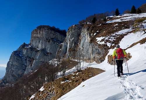
Here it begins a beautiful itinerary that follows an old military road across some war tunnels in constant view of the rocky wall of the Corno della Paura and in breathtaking exposure on the Valle dell'Adige over 1000 meters below.
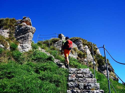
The road leads to a wooden gate (please close it after crossing) immediately past which you find yourself at a pole with different SAT signposts nearby a road.
From the signposts take a narrow track that climbs to the left of the signposts the grassy slopes of the Corno della Paura reaching briefly the summit in spectacular sight on the Adige Valley, the Baldo-Altissimo Group, the Brenta Dolomites, the Chain Stivo-Bondone. On the top there are some conspicuous remains of the Great War, fences and benches. From the summit a let's take a stone staircase leading briefly to visiting some military posts.
Descent: reverse the same route
From Valle dell'Adige
Corno della Paura from Valle dell'Adige
Summit quote: 1518 m
Difficulty: E
Difference in level: 1300 m
Time required: 5 hours for the ascent
Starting point: Castello Sabbionara d'Avio
Easy itinerary, anyhow requiring a good training due to the considerable difference in level. Not recommended in the summer season
The parking lot is at an altitude of 230 m, the road continues up to the castle but cars are not allowed beyond the car park. From the castle of Avio it begins the path 686 that goes up the valley of Castel up to Bocca d'Ardole 1390 m. From here we follow the previous itinerary, keeping the large military path on the left which is always CAI 686 in the direction of the well visible tunnel to which others will follow. We ignore after a few meters the path to the right to malga Susine. Go through the tunnels, the military path leads us to a wooden gate before the prairies of the Corno della Paura, signposts. We go to the left going up the path that leads us to the nearby summit. On the top there are some testimonies of the great war , fences and benches.
Other routes
On the steep limestone wall of Corno della Paura there are some climbing routes.
Red Tape
No fees no permits required
Hiking and scrambling scale
T - Turistico (Tourist): Itineraries on wide, clear and well worn paths, sometimes on mule tracks or gravel roads. The routes are never exposed, don't give any orientation problems and don't exceed 2500 meters of altitude. Suitable also for children
E - Escursionisti (Hikers): Itineraries on marked trails, even narrow and with possible steep and impervious sections. They are never exposed and don't give any orientation problems. They can tread different kinds of ground, such as forests, gravel, meadows, pastures, easy rocks, etc.). They form the majority of the trails that wind up in the mountains and require a certain habit to walk; you need equipment suitable for the altitude and resistant footwear with soles suitable for rough terrain
EE - Escursionisti Esperti (Experienced Hikers): Itineraries for hikers with experience and good knowledge of the mountain. Some of these paths may have exposed sections, however brief, which require firm foot and no dizziness. They require the ability to adapt to particular terrain, such as steep grassy slopes or stretches of rocks with difficulties that can reach the 1st degree of the UIAA scale. They can also reach high altitudes (3000 m or more). Sometimes they may include unmarked sections, requiring a good sense of orientation. Snow slopes are possible, however which can be overcome without specific mountaineering gear (rope, harness, crampons, ice-axe)
EEA - Escursionisti Esperti con Attrezzatura (Experienced Hikers with equipment - The same as EE, in addition these routes require the use of via ferrata equipment (lanyards, harness, carabiners, heat sink, helmet). This kind of itineraries range from the trails with short easy and not much exposed sections, previously equipped with fixed ropes and iron pegs, to the true and more difficult Via Ferratas climbing on rocky walls or on aerial ridges and ledges, previously equipped with long stretches of iron ropes, iron steps, ladders without which proceeding would constitute a real climbing. It is necessary to know how to use the technical equipment and have a certain habit of exposure and mountaineering terrains.
Flora and Fauna
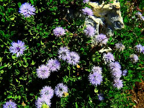
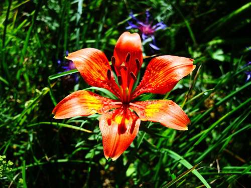
Corno della Paura as the nearby Monte Vignola is located inside the natural park of Monte Baldo range,a vast protected area set up to protect the natural environments of Monte Baldo with their flora and fauna, established in 2013. In fact, in addition to an interesting fauna, there are various notable floristic rarities in the area. The park extends in the Trentino area of Monte Baldo and is shared by the municipalities of Ala, Avio, Mori and Nago-Torbole. Moreover Bocca d'Ardole – Corno della Paura is a site of international importance (Nature 2000 in Trentino) in reason of being a crossing point for the transit of many medium and long-range migratory species in the late summer and autumn periods (post-breeding migration).
When to Climb
All year round. In winter time the ground is often snowy but the route from La Polsa is available without particular problems.
Accomodation
Various possibilities in La Polsa and Brentonico. Camping in La Polsa.
Bibliography and maps
Monte Baldo Kompass sheet 129
Meteo forecast
External Links
Trentino Grande Guerra
Parco Monte Baldo