
-
 9601 Hits
-
 90.81% Score
-
 33 Votes
|
|
Mountain/Rock |
|---|---|
|
|
45.53100°N / 7.35372°E |
|
|
Mountaineering |
|
|
11286 ft / 3440 m |
|
|
Overview
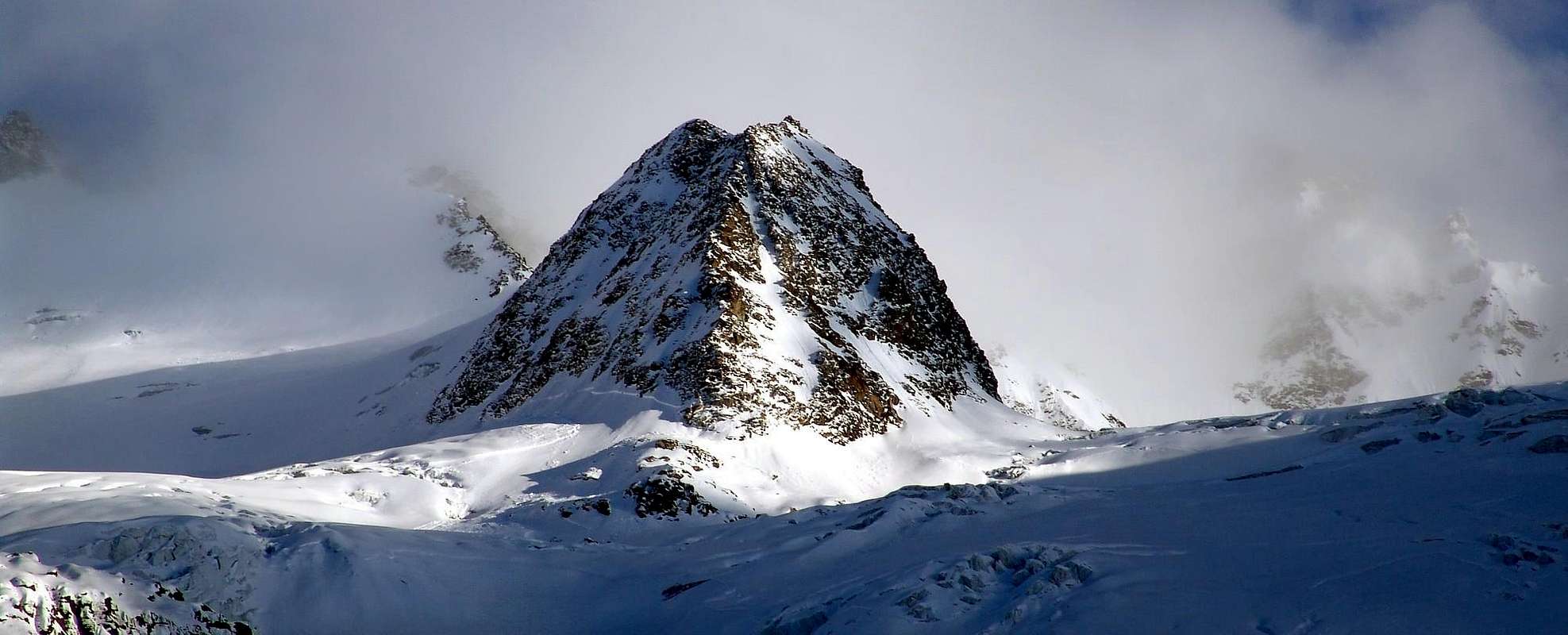
Atypical top constituted by a great rocky-glacial groin that goes down from the Torre di San Orso (= Saint Ours also Saint "Bear", not dedicated to a bear, but really to Saint "Apostle" of Aosta Valley, as well as Patron of the City) I pour W-NW, action to separate in two parts the vast Glacier of Money dividing it in the Glacier Coupe de Money, to North, and in that more in general sense of Money, to South. After the aforesaid tower, the brief Crest SW of the same form an ample round glacial saddle, raises again him of few to the Quota 3.605m (3.610m in the most recent cartography), it goes down in more abrupt way to a following small pass (Paganini Pass; 3.456m and continuous toward the Summit of the Cresta Paganini 3.440m; currently 3.447m in the Paper of the Autonomous Region of the Valley of Aosta and in that de "The Excursionist", where the hill is amiss rated 3.555m, this quota surely reporting itself to the overhanging saddles glacial above quoted and, as it is deduced by the symbology of the sketch, such to put in communication the Glacier Coupé de Money with the minuscule Glacier de Tours in tall Valeille. The Hill in matter, easily passable on both the sides North and South, remain instead more to West and colleague the two glaciers of which it initially spoke, both instead belonging to the Valnontey); after this, the line of crest forms the culminating point for then to descend gradually slightly bending itself toward W-NW and to definitely bathe herself in the conjunction among the two glaciers to quota 3.200/25m around. Paradoxically it achieves to result of it, perhaps case unique than rare, lower peak of the near hill, of a two weeks of meters more elevated; reality consists that the Crest Paganini (what it draws name from the famous Italian cartographer Pio Paganini, author of the first Paper of the Great Paradiso) it is not a true top, on the contrary a great rib posts between the Tower of Sant'Orso and the Point Northeast of the Tower of Sant'Andrea. You underlines of eccentric form to iron from I stretch and very similar to the initial part of the Spur of the Brenva to the Mount Blanc (1865 Moore Route). It deserves to rise to the rank of Peak however, if nothing else because very well delineated on the Westerner side of the Chain of the Apostles (on which dominates the Torre del Grande San Pietro (3.692m), the more elevated and surely the most in view) of which breaks the continuity of it in the sense South/North, for the name that honours the great engineer-topographer and, finally, for some beautiful alpine routes on the glacial Slope North, as well as on the rocky edge W-NW. Not very frequented by the mountain climber, she is crossed at times in descent after the crossing of the Apostles or, more simply, combining it to the slope of the Tower of Saint'Orso (= Bear Tower). Therefore and in almost every case it results more as point of transit that not of elegant destination to herself. Splendid panorama and particular glimpses on the aforesaid chain and, more in distance, on the GROUP of the Gran Paradiso and famous "The Grivola Beautiful" (of the Poet Giosué Carducci) and smart, more in distance, and the underlying great Glacier of the Tribulation, enlarged toward Westerner spaces and extended in Southerner/Northerner axe.
First Ascents
- First on the summit: Giovanni Bobba, George Yeld and mountain guides Francesco Pession Valtournenche's and G. Jeantet Cogne's, (Aug 19th, 1893).
- In winter: Unknown.
- W-NW Wall (Direct Route) Giovanni Bobba, George Yeld, with mountain guides Francesco Pession of Valtournenche and G. Jeantet of Cogne, (Aug 19th, 1893).
- N Face Diagonal Route East/West: Ilario Antonio Garzotto and Osvaldo Cardellina; Ruggero Busa and Pino Trevisan, (Jul 13th, 1969), in descent( * after the first replay of Northwest Wall Patrì's Points, Guichardaz-Cammelli Route, by Northwest Face and SW Crest in descent), and traverse, through Money's Pass, to Saint Ours Tower, by Northwest Face), in descent.
- N Face (Direct Route to Left or East): Vittorio Badini Confalonieri and Ettore Passerin d'Entrèves, (Aug 18th, 1934), in ascent.
- E Crest: Giovanni Bobba, George Yeld with mountain guides Francesco Pession of Valtournenche and G. Jeantet of Cogne, (Aug 19th, 1893).
Getting There
BY CAR:- From Torino, Milano, etc: Motorway A5. Exit at Aosta Ovest. Drive to the near Aymavilles. Follow the directions for Valle di Cogne.
- From Switzerland: through the Grand Saint Bernard Tunnel or the namesake Pass. Drive to Aosta, then follow the direction for Courmayeur on SS.26. Just after Sarre, turn to the left, in the direction of Valle di Cogne.
- From France: through Mont Blanc Tunnel or Petit St. Bernard Pass. It isn't necessary to take Motorway A5: you can drive on SS.26, in the direction of Aosta. Before arriving at the Village of Sarre, turn right following the sign for Valle di Cogne. After Aymavilles, the Regional Road n°47 crosses the Villages of Vieyes, Epinel and Cretaz and after about 25 Km arrives at Cogne (1.534m). From Cogne you can get the Village of Valnontey (1.666m).
- Aeroporto "Corrado Gex" Saint Christophe (Aosta).
Approaches
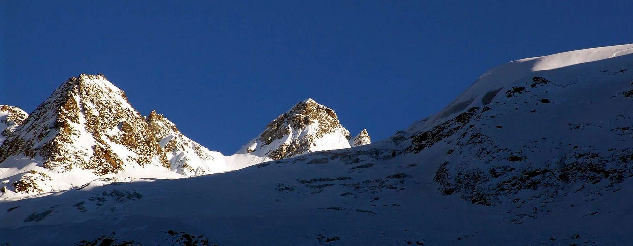
From the small parking in asphalt or from the nearby in soil of Valnontey Village (1.666m; stonefountain near the restaurant/ice-cream machine; possible beautiful rides along the Valnontey Torrent or brief excursions by horses), follow the easy trail n° 22/TVC (= Tour of Aosta Valley Great Paradise) going up along the walloon. After the pleasant Hamlet of Valmiana (1.728m; good old "rascards", also stony/wooden mountain houses) continue, always gently uphill, till a fork (0h'45). Turn left, following the path-muletrack n° 22C to the Money Bivouac, which begins to rise steeply. After 1h'00/1h'15 a long traverse brings one in view of the Money Hut (ruins) at 2.325 meters. Shortly before reaching them, turn left and go towards the ridge of the side lateral right, also Northern, moraine of the Coupé di Money Glacier. Follow the panoramic ridge of the moraine (from which progressively begins to "to reveal" himself the splendid Chain of the Apostles and, more to South, the Tall Head of the Valnontey with the East Wall of the Great "Heaven" also Paradise that slips inside the Tribulation), to its end, cross towards left a field of talus and broken rocks; with the help of a fixed rope enough easily climb, but with caution, a short gully, then a somewhat exposed path leads quickly to the bivouac, easily distinguishable since it is (or, better, it was) painted yellow. The bivouac, placed at 2.872m (3h'45/4h'00 hours from Valnontey), is in a very panoramic position with respect to the Great Paradise Central Mountain Chain. Drinkable water may be found at a short distance above the bivouac, coming from Patrì Glacier. APPROACHES various from MONEY's BIVOUAC (2.872m) towards COUPE's GLACIER, nearby the MONEY's (2.872m) PASS (3.489m) & FINGER (3.506m), to PAGANINI HILL (3.456m) & CREST (3.440m).
 |
 |
 |
 |
 |
Dal piazzale in asfalto oppure dall'attiguo in terra battuta del piccolo Villaggio di Valnontey (1.666 m: bella fontana in pietra presso il ristorante-gelateria; possibilità di belle passeggiate lungo il circuito sul Torrente di Valnontey, nonché brevi escursioni tramite cavalli) seguire il sentiero-strada poderale n° 22/TVC (= Tour de la Vallée d'Aoste Grand Paradis) lungo il fondo del vallone per raggiungere il piacevole Villaggio di Valmiana (1.728 m; antichi e bei "rascards" in pietra e legno), e continuare, sempre dolcemente, in salita sino ad un bivio (0h'45). Girare sulla sinistra sempre seguendo il sentiero-mulattiera n° 22C, indirizzantesi al Bivacco di Money, che comincia a risalire più ripidamente. Dopo 1h'00/1h'15 una lunga traversata porta in vista dell'antica Alpe di Money (con le sue rovine) a 2.325 metri. Poco prima girare ancora a sinistra e rimontare verso il filo di cresta della morena laterale destra (Nord) del Ghiacciaio di Coupé de Money. Seguire l'apice della cresta panoramica (dalla quale progressivamente incomincia a "svelarsi" la splendida Catena degli Apostoli e, più a Meridione, l'Alta Testa della Valnontey con la Parete Est del Gran Paradiso, scivolante dentro la Tribolazione), insino al suo termine, ove attraversare verso sinistra una pietraia con rottami; superare nella parte finale con l'aiuto di una corda fissa un breve salto roccioso, poi con percorso piuttosto esposto, ma non difficile e tale da richiedere soltanto attenzione, raggiungere rapidamente il bivacco, facilmente distinguibile dal colore giallo (o, meglio, lo era). Lo stesso è posizionato a 2.872 metri (3h'45/4h'00 ore dal piazzale di Valnontey), in un sito molto panoramico rispetto alla Catena Centrale del "Granpa". Acqua bevibile può essere trovata a breve distanza sopra il bivacco, proveniente dal Ghiacciaio di Patrì.
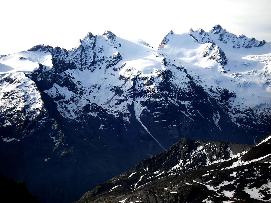
LANDSCAPE of the MOUTAIN CHAIN, by Paolo Ollietti
The nearly whole Watershed from North towards South, between Valontey (picture)/Valeilles Valleys into Cogne Valley, VIEWED from the opposite ridge between Cogne/Valsavarenche Valleys of GREAT PARADISE.A) - From left or Northern Ridge: TSISSETTA POINT (3.417m) with Valletta Glacier and PATRI' PASS (3.359m), PATRI Northern (3.516m) & Southern (3.579m) POINTS with of Patrì Glacier, COUPE' of MONEY PASS (3.383m) & APOSTLES FINGER (3.434m), SAINT OURS, SAINT ANDREAS, SADDLE 3.558 meters, GREAT SAINT PETER TOWERS.
B) - From South to Southwest: the SW Ridge of Great Saint Peter, the QUOTA 3.501 meters to MONEY PASS (3.420m), on watershed between Cogne/Teleccio also Telessio (Angelere Tableland over the Carpano Bivouac) Valleys; watershed between AOSTA VALLEY and Locana-Orco Valley, into REGION PIEDMONT.
C) - In bottom, wedged into Coupé and Money Glaciers, the SHOULDER 3.605/10 meters, PAGANINI PASS (3.456m) & RIDGE (3.440m).
Routes
A) - For the East Crest through the junction Glaciers of Coupe de Money Glacier de Money, as well as along the South Slope of the Paganini Pass: from the Bivouac of Money (2.872m), to go down the first line again entering the small valley to quota 2.880/90m around; to go up again long traces toward East passing to side of the small rocky promontory 2.917m and to continue, same direction, along the steep moraine (draws that it asks for prudence and attention) flanking the Glacier Coupé de Money, that is reached near the quota 3.053m. To actually go up again on the fund of the small long "vallone" of the snowy plateaus of average inclination to the rates of 3.150m around, where progressively it is begun to turn to the right (South) continuing in false level route; after having overcome to small snowy hump, to brief descent effects him bringing himself toward the rates 3.216m at basic the of the Cresta Paganini, Western Side, in to zones rather flood of crevasses. To double on the left the Edge W-NW and the rocky triangular Wall W of the same one and with a steep slope mostly, leaving on the right (West) a great area of enormous crevasses hemi circular that goes down to fall in direction Northwest, to almost reach the superior icy tableland of the Glacier de Money against the Wall NW of the Tower of the Grande San Pietro and, more precisely, at the base of the frozen slide that goes up again on the crest watershed between this last and the Point SW about the Torre di Sant'Andrea; reversing completely broken by North South to pass under the Walls West of the two Saint Andreas bringing under himself to the Paganini Pass. With easy and brief slope to reach it through rocks broken alternating to small snowfields; from the small pass to turn to the left (West) and quickly through the East Crest to reach the Peak (EE/A; F; 1h'30/2h'30 according to the conditions of the glaciers).A) - Per la Cresta Est tramite la congiunzione dei Ghiacciai del Coupé de Money e de Money, nonché il Versante Sud del Colle Paganini: dal Bivacco di Money (2.872 m), scendere il primo tratto entrando nuovamente nel vallone a quota 2.880/90 m~; risalire lungo tracce verso Est passando a lato del piccolo promontorio roccioso (2.917 m) e continuare, stessa direzione, lungo la ripida morena (tratto che richiede prudenza ed attenzione) fiancheggiando il Glacier Coupé de Money, che si raggiunge presso la quota 3.053 m Risalire sul fondo del piccolo vallone lungo dei plateau nevosi di media pendenza sino alla quota di 3.150 m~, dove progressivamente si incomincia a svoltare a destra (Sud) proseguendo in falsopiano; dopo aver superato una piccola gobba nevosa, si effettua una breve discesa portandosi verso la quota 3.216 metri alla base della Cresta Paganini, lato occidentale, in una zona alquanto piena di crepacci. Doppiare sulla sinistra lo Spigolo W-NW e la rocciosa triangolare Parete W della medesima e con una salita maggiormente ripida, lasciando sulla destra (Ovest) una grande area di enormi crepacci semicircolari che scendono a cascata in direzione Nordovest, raggiungere il pianoro superiore del Glacier de Money quasi contro la Parete NO della Torre del Gran San Pietro e, più precisamente, alla base dello scivolo ghiacciato che risale sulla cresta spartiacque tra questa ultima e la Punta SO della Torre di Sant'Andrea; invertendo completamente rotta da Sud a Nord passare sotto la parete O dei due Sant'Andrea portandosi sotto al Colle Paganini. Con facile e breve salita raggiungerlo tramite rocce rotte alternate a piccoli nevai; dal piccolo colle svoltare a sinistra (Ovest) e rapidamente per mezzo della Cresta Est raggiungere la Vetta (EE/A; F; 1h'30/2h'30 a seconda delle condizioni dei ghiacciai).
 |
 |
 |
 |
 |
B) - For the East Crest, through the Coupé Glacier of Money and Northerner Slope of Paganini Pass: from the preceding itinerary from Money Hut (2.872m) or directly from the moraine arriving from Money's Pasture (wanting to complete in day the ascension from Valnontey very practicable choice, especially in case of overcrowding, verifiable factor easily in the months of July and August), and, leaving to North the Southerner Slope the Standard Route towards the two Punte Patrì (Southern 3.597m and Northern 3.516m), whereas the same turns to south, to continue the slope up to around two bystanders of the glacier with in sight the Coupe de Money Pass (3.383m) and the characteristic Dito degli Apostoli (3.434m), that he hacks against the sky from this point, changing twice direction in Northeast to Southeast; toward quota 3.280/3.300m around to still vary direction and decidedly toward South and, left to the left the route for the aforesaid pass, with a long diagonal of average inclination to pass under the Walls NW of the Torre di Sant'Orso (3.618m) and of his Shoulder West or Quota 3.605m (currently 3.610m). With an a little steep line to reach the great semi circular bergsrunde that encircles to the base the quota aforesaid and thin against the Wall N of the Crest Paganini. With a last steep slide the Pass Paganini and he are reached it continues toward the Top along the Crest it is as in the preceding itinerary (EE/A; F+; 1h'30/2h'30 according to the conditions of the glaciers).
B) - Per la Cresta Est tramite il Ghiacciaio del Coupé de Money ed il Versante Nord del Colle Paganini: dall'itinerario precedente partendo dal Bivacco di Money (2.872 m) oppure direttamente continuando dall'alpeggio omonimo lungo la morena e quindi senza effettuare alcuna diversione verso il medesimo (volendo effettuare in giornata la salita, scelta possibilissima, soprattutto in caso di sovraffollamento del bivacco medesimo, fattore facilmente riscontrabile nei mesi di Luglio ed Agosto), laddove lo stesso volge a meridione, continuare la salita fino a circa due terzi del ghiacciaio con in vista il Colle Coupé de Money (3.383 m) ed il caratteristico Dito degli Apostoli (3.434 m), che da questo punto si staglia contro il cielo, cambiando due volte direzione in NE e SE; verso quota 3.280/3.300 metri circa variare ancora direzione e decisamente verso Sud e, lasciata a sinistra (E) la via per il suddetto colle nonché a Settentrione quella della Via Normale alle due Punte Patrì (Sud 3.597 m e Nord 3.516 m), con un lungo diagonale di media pendenza passare sotto le Pareti NO della Torre di Sant'Orso (3.618 m) e del suo Spallone Ovest o Quota 3.605 metri (attualmente 3.610 m). Con un tratto poco più ripido raggiungere la grande crepaccia semicircolare che cinge alla base la quota suddetta e fino contro la Parete N della Cresta Paganini. Con un ultimo scivolo più ripido si raggiunge il Colle Paganini e si prosegue verso la Cima lungo la Cresta E come nel precedente itinerario (EE/A; F+; 1h'30/2h'30 a seconda delle condizioni dei ghiacciai).
Difficulties
The routes, classified F+ and F, is to be undertaken by expert climbers in good physical conditions.Le vie sono da classificarsi in F+ e F e rivolte ad alpinisti esperti ed in buone condizioni fisiche.
MAPS:
Equipment
High mountain equipment, rope, axe, crampons, helmet, a few rock and ice pegs (even if not used).Red Tape
Inside the borders of the P.N.G.P. (Parco Nazionale del Gran Paradiso), at the moment (summer 2004) dogs generally are not allowed, except a pair of paths, and free camping is forbidden (except for climbers from sunset till dawn). No fees are due.Campings
- Wild camping in the Parco Nazionale del Gran Paradiso is strictly forbidden!!! There are three camping sites very near to Valnontey Village. The most appropriate support point is the Money Bivouac.
Mountain Condition
- Meteo: you can find all the needed informations at the official site of the Valle d'Aosta Region:
- Valle d'Aosta Meteo
- Meteo: You can find more weather information on the website 3B Meteo:
- Meteo Cogne
- Meteo: You can find more weather information on the website 3B Meteo:
- Meteo Valnontey
Webcam
- WEBCAM on Aosta Valley:
- Webcam
Books and Maps
BOOKS:- "Guida delle Alpi Occidentali" di Giovanni Bobba e Luigi Vaccarone C.A.I. Sezione di Torino Volume II° (parte II) 25-05-1896.
- "Guida dei Monti d'Italia-Gran Paradiso Parco Nazionale" E. Andreis, R. Chabod, M. C. Santis, Club Alpino Italiano/Touring Club Italiano, prima Ed. 1939; seconda Ed. 1963; terza Ed. 1980.
- "Guida della Regione Autonoma Valle d'Aosta" di Mario Aldrovandi, Ed. S.P.E. di Carlo Fanton Torino 1964.
- "Rifugi e bivacchi in Valle d'Aosta" di Cosimo Zappelli aggiornata da Pietro Giglio. Musumeci Editore, Luglio 2002.
- "Il Parco Nazionale del Gran Paradiso (Valli di Champorcher-Clavalitè-Saint Marcel-Laures-Cogne-Valsavarenche-Conca di Pila" di Giulio Berutto 3/volume 2°, IGC, Torino 1981, 2a Ed. 2000.
- A. Gegenfurtner, G. Klotz, F. Müller "Gran Paradiso", Ed. Bergverlag Rudolf Rother, Monaco 1980 (in tedesco).
- G. Klotz "Gran Paradiso" Ed. Bergverlag GmbH Rother, Monaco 2005 (in tedesco).
- "Gran Paradiso" di Pierandrea Mantovani e Renato Misischi, Ed. Rassegna Alpina 1974.
- "Gran Paradiso - Itinerari Alpinistici e sci Alpinistici" di Franco Brevini Ed. Musumeci, Giugno 1982.
- "Diari Alpinistici" di Osvaldo Cardellina e Indice Generale accompagnato da Schedario Relazioni Ascensioni 1964-2019 (inediti).
 |
 |
 |
 |
- Kompass - "Gran Paradiso Valle d'Aosta Sentieri e Rifugi" Carta Turistica 1:50000.
- Enrico Editore Ivrea-Aosta – "Gruppo del Gran Paradiso" 1:50000.
- I.G.C. Istituto Geografico Centrale Torino "Gran Paradiso-La Grivola-Cogne" 1:25.000.
- A.I.A.T. "Cogne Gran Paradiso Aymavilles - Walking Map" 1:25.000.
- I.G.C. Istituto Geografico Centrale Torino "Il Parco Nazionale del Gran Paradiso" (3) 1:50.000.
- L'Escursionista "Valle di Cogne Carta dei Sentieri" (n° 10) 1:25.000.
- L'Escursionista "Tour de la Vallée de Cogne Grand Paradis" Carta dei sentieri 1:25.000.
Important Information
- REGIONE AUTONOMA VALLE D'AOSTA the official site.
- FONDAZIONE MONTAGNA SICURA Villa Cameron, località Villard de la Palud n° 1 Courmayeur (AO) Tel: 39 0165 897602 - Fax: 39 0165 897647.
- SOCIETA' GUIDE ALPINE DI COGNE Tel. 347/9473526 – 328/1373728.
- A.I.NE.VA. (Associazione Interregionale Neve e Valanghe).
- A.IA.T. Cogne Gran Paradis via Bourgeois n° 34 Tel. 0165-74040. E-mail: aiat@cogne.org
- Ezio Sport articoli sportivi - via Bourgeois n° 64 Tel. 0165-74204.
Useful Numbers
- Soccorso Alpino Cogne (SAR) Tel. 3482685406.
- Protezione Civile Valdostana località Aeroporto n° 7/A Saint Christophe (Ao) Tel. 0165-238222.
- Bollettino Meteo (weather info) Tel. 0165-44113.
- Unità Operativa di Soccorso Sanitario Tel. 118.