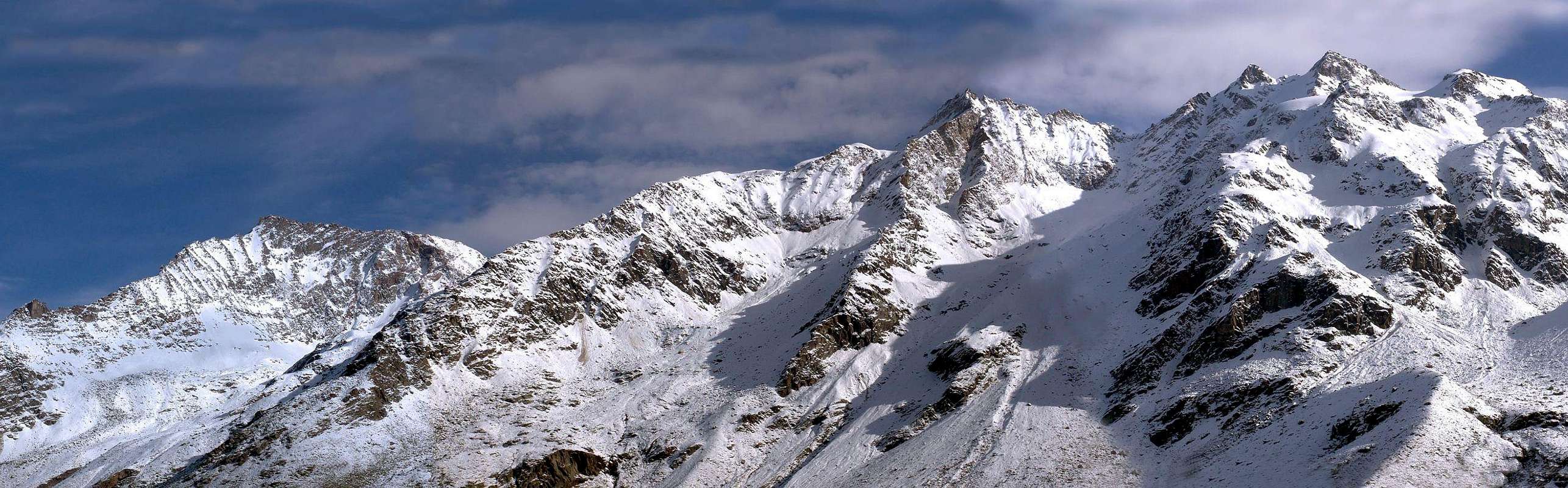
This Summit is placed between the Valeille and that of Valnontey always inside the Cogne valley at the foot of Gran Paradiso (4.061m) and more specifically near the end of that long watershed, originandosi in the Gran San Pietro (3.692m) in the Chain of the Apostles, it is able to separate these two valleys. Ending with the Montseuc (2.333m) above the village of Cogne. It is a beautiful rocky pyramid, formed by three ridges with many sides, in full view of Cogne but poorly frequented mainly by the length of his two approaches; fact is that starting from Valnontey or from Lillaz through Valeille requests are half a dozen hours for the ascent, five of which on both sides to reach the Colle Valmiana (3.093m). Since from this takes place the ascent through pretty easy Via Cresta Southwest Normal or that requires little more than an hour with some bypass on the right (East or Valeille). Beautiful view towards the West on the whole of Gran Paradiso Group until the Grivola (3.969m), while the front relaxes the Apostles Mountain Range. In the East the view rolls over the Group of Arolla between Valeille and the Vallon Bardoney.
Questa Cima si trova collocata tra la Valeille e quella di Valnontey sempre internamente alla Valle di Cogne ai piedi del Gran Paradiso (4.061 m) e più precisamente quasi al termine di quel lungo spartiacque che, originandosi nel Gran San Pietro (3.692 m) nella Catena degli Apostoli, è atto a separare questi due valloni. Terminando con il Montseuc (2.333 m) sopra lo abitato di Cogne. Si tratta di una bella piramide rocciosa, formata da tre creste con altrettanti versanti, ben in vista da Cogne ma scarsamente frequentata soprattutto per la lunghezza dei suoi due avvicinamenti; infatti sia partendo dalla Valnontey che da Lillaz tramite la Valeille sono richieste una mezza dozzina di ore per la salita, delle quali cinque su entrambi i lati per raggiungere il Colle di Valmiana (3.093 m). Da questo si svolge la salita tramite la abbastanza facile Via Normale o Cresta Sudovest che richiede poco più di un'ora con qualche aggiramento sulla destra (Est o Valeille). Bella vista verso Occidente sullo intero Gruppo del Gran Paradiso fino alla Grivola (3.969 m), mentre frontalmente si distende la Catena degli Apostoli. Ad Oriente la vista scorre sopra il Gruppo dell'Arolla tra la Valeille ed il Vallone del Bardoney.
First Ascents
First on the Summit: Giovanni Bobba with Cogne Guides Louis Gadin and Eliseo Jeantet, (Aug 16th, 1893), from Colle Valmiana and by Southwest Crest.
In winter: Unknown.
Southwest Crest (normal Route): Giovanni Bobba with Cogne Guides Louis Gadin and Eliseo Jeantet, (Aug 16th, 1893), from Colle di Valmiana.
Getting There
BY CAR:
From Torino, Milano, etc: Motorway A5. Exit at Aosta Ovest. Drive to the near Aymavilles. Follow the directions for Valle di Cogne.
From Switzerland: through the Grand Saint Bernard Tunnel or the namesake Pass. Drive to Aosta, then follow the direction for Courmayeur on SS.26. Just after Sarre, turn to the left, in the direction of Valle di Cogne.
From France: through Mont Blanc Tunnel or Petit St. Bernard Pass. It isn't necessary to take Motorway A5: you can drive on SS.26, in the direction of Aosta. Before arriving at the Village of Sarre, turn right following the sign for Valle di Cogne. After Aymavilles, the SR.47 crosses the Villages of Vieyes, Epinel and Cretaz and after about 25 Km arrives at Cogne (1.534m).
From Courmayeur Resort: in East-southeast to Aosta West near Aymavilles Common; from this, passing Vieyes, Epinel and Cétaz Hamlets, until Cogne Municipality.
From Aosta City in West towards Aymavilles Commune; from this up to the Cogne Common.
BY PLANE:
Aeroporto "Corrado Gex" Saint Christophe (Aosta).
Approachs
A) - From the Colle della Grandzetta Valnontey (2.933m): immediately after the village of Valnontey to the Village of Valmiana bend far to the left (East) and through the path n° 22A trail along the small stream directed towards a rocky outcrop isolated in the woods (the same is also clearly visible looking from Cogne). Near to this and just below the trail becomes more obvious and obligatory passing some rocky steps back with good reports from the remains half-covered by vegetation of Alpe Grandzetta (E/F; 2.140m; 1h'45/2h'15 from Cogne). Going on the right some grassy slopes you arrive at Pian della Tournetta (2.418m; 0h'30/0h'40) with stunning views of the Gran Paradiso and beautiful glances on the Conca Loson or Lauson. Continuing through scree slopes and a more steep and difficult gully to reach the hill (EE/F; 4h'30/5h'00 from Cogne).
B) - From Valeille the Colle della Grandzetta (2.933m): From the deck of Champlong back to the right of pretty meadows without crossing the same reaching the forest surrounded by large boulders. Reach the Alpe di Cheleret (1.750m) located on the left bank of the entry into Valeille and go through a not always clear path to the southwest between steep grassy slopes interspersed with rocky ledges reaching diagonally across the small stream that originates from the hill. Take this small valley with some difficulty to find the right path until you reach the Alpe di Fenilia, dilapidated and poorly visible and positioned on the opposite bank of the stream (downhill this stretch is even less obvious) that follows along steep grassy slopes reaching the hill with difficulty (EE/F +; 4h'30/5h'00 from Champlong).
A) - Dalla Valnontey al Colle della Grandzetta (2.933 m): subito dopo lo abitato di Valnontey verso il Villaggio di Valmiana piegare decisamente verso sinistra (Est) e tramite tracce di sentiero n° 22A lungo il piccolo ruscello indirizzarsi verso uno spuntone roccioso isolato dentro il bosco (lo stesso risulta ben visibile anche guardando da Cogne). Nei pressi di questo ed appena al di sotto il sentiero diventa più evidente ed oltrepassando obbligatoriamente alcuni gradini rocciosi risale con buone segnalazioni verso i resti semicoperti dalla vegetazione dell'Alpe Grandzetta (E/F; 2.140 m; 1h'45/2h'15 da Cogne). Risalendo sulla destra alcuni pendii erbosi si arriva al Pian della Tournetta (2.418 m; 0h'30/0h'40) con splendida vista sul Gran Paradiso e bei colpi d'occhio sulla Conca del Loson o Lauson. Continuando tramite pendii detritici e con un canalino più ripido e faticoso si raggiunge il colle (EE/F; 4h'30/5h'00 da Cogne).
B) - Dalla Valeille al Colle della Grandzetta (2.933 m): Dal ponte di Champlong risalire verso destra su prati graziosi senza attraversare il medesimo raggiungendo il bosco contornato da grandi massi. Raggiungere l'Alpe di Cheleret (1.750 m) posta sulla sinistra orografica dello ingresso nella Valeille e proseguire per mezzo di un sentiero non sempre evidente verso Sudovest tra ripidi pendii erbosi alternati a salti rocciosi raggiungendo in diagonale il piccolo torrente che proviene dal colle. Percorrere questo piccolo vallone non senza difficoltà per reperire la giusta via fino a raggiungere l'Alpe di Fenilia, diroccata e scarsamente visibile nonché posizionata sulla sponda opposta del torrentello (in discesa questo tratto risulta ancora meno evidente) che si segue percorrendo ripidi pendii erbosi raggiungendo faticosamente il colle (EE/F+; 4h'30/5h'00 da Champlong).
Route
From Colle della Grandzetta through the Eastern Slope and Northern Crest: back resting on the snow fields on the left; the same, alternating with easy scree slopes and bottles from the primary path, reach the second rocky rib that comes from the Northeast starting from the altitude 3.204 meters; from this conjunction quickly and easily to the summit (3.244m; EEA/F to F+; 1h'30/2h'00 from the hill).
Dal Colle della Grandzetta tramite il Versante Orientale e la Cresta Settentrionale: risalire appoggiando sui nevai a sinistra; gli stessi, alternati a facili pendii detritici e boccette dal percorso elementare, raggiungono la seconda costola rocciosa che proviene da Nordest partendo dalla quota 3.204 metri; da questa congiunzione in breve tempo e facilmente alla Sommità (3.244 m; EEA/da F a F+; 1h'30/2h'00 dal colle).
Difficulties
This route can be considered EEA/F+ for the Southwest Ridge.
L’itinerario è da classificare in EEA/F+ per la Cresta Sudovest.
Within the borders of the P.N.G.P. (Parco Nazionale del Gran Paradiso), at the moment (summer 2004), dogs generally are not allowed, except on a couple of trails, and camping is forbidden (except for climbers from sunset till dawn). No fees are due.
Books and Maps
BOOKS:
"Guida delle Alpi Occidentali" di Giovanni Bobba e Luigi Vaccarone C.A.I. Sezione di Torino Volume II° (parte II) 25-05-1896.
"Guida dei Monti d'Italia-Gran Paradiso Parco Nazionale" E. Andreis, R. Chabod, M. C. Santis, Club Alpino Italiano/Touring Club Italiano, prima Ed. 1939; seconda Ed. 1963; terza Ed. 1980.
"Il Parco Nazionale del Gran Paradiso (Valli di Champorcher-Clavalitè-Saint Marcel-Laures-Cogne-Valsavarenche-Conca di Pila" di Giulio Berutto 3/volume 2°, IGC, Torino 1981, 2a Ed. 2000.
"Gran Paradiso - Itinerari Alpinistici e sci Alpinistici" di Franco Brevini Ed. Musumeci, Giugno 1982.
MAPS:
Kompass - "Gran Paradiso Valle d'Aosta Sentieri e Rifugi" Carta Turistica 1:50.000.
Enrico Editore Ivrea-Aosta – "Gruppo del Gran Paradiso" 1:50.000.
I.G.C. Istituto Geografico Centrale Torino "Gran Paradiso-La Grivola-Cogne" 1:25.000.
A.I.A.T. "Cogne Gran Paradiso Aymavilles - Walking Map" 1:25.000.
I.G.C. Istituto Geografico Centrale Torino "Il Parco Nazionale del Gran Paradiso" (3) 1:50.000.
L'Escursionista "Valle di Cogne Carta dei Sentieri" (n° 10) 1:25.000.
L'Escursionista "Tour de la Vallée de Cogne Grand Paradis" Carta dei sentieri 1:25.000.
Parents refers to a larger category under which an object falls. For example, theAconcagua mountain page has the 'Aconcagua Group' and the 'Seven Summits' asparents and is a parent itself to many routes, photos, and Trip Reports.

 2971 Hits
 83.69% Score
 17 Votes