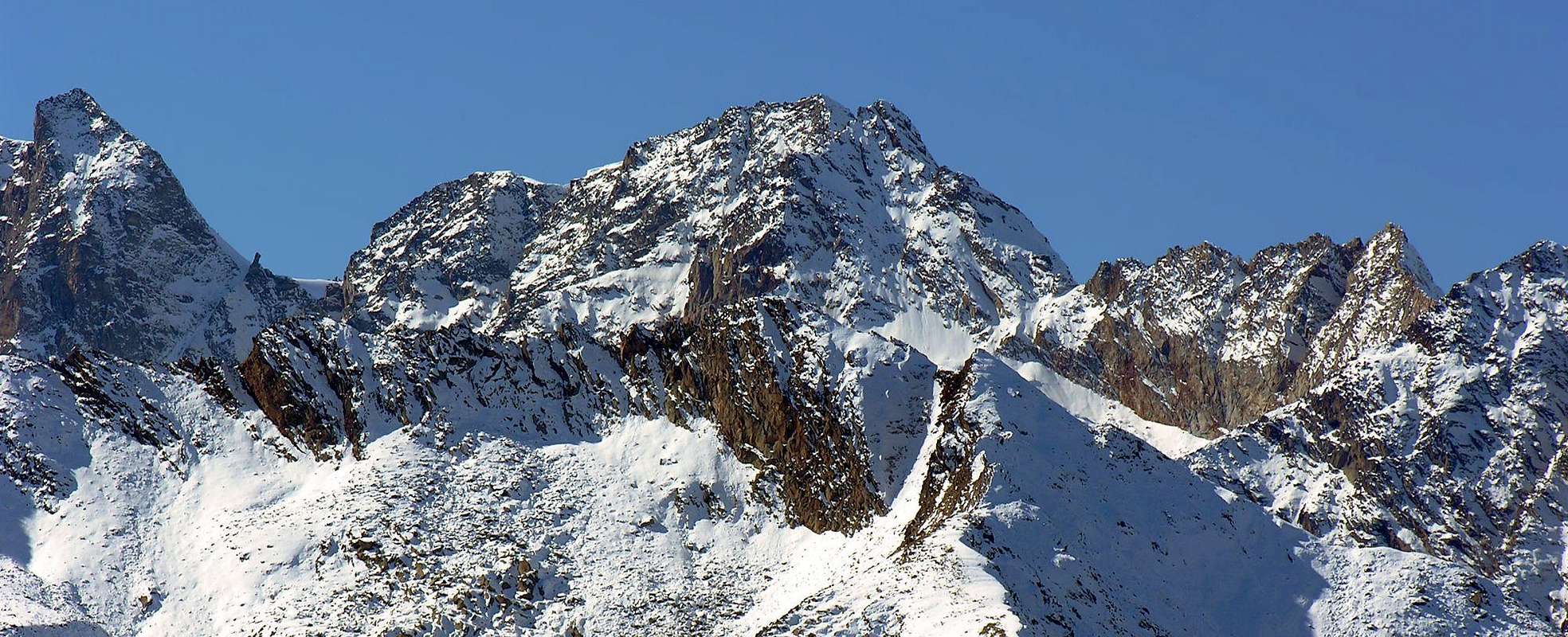
This beautiful Summit can be considered as the last of some importance in the long watershed which originates at Tower ofl Gran San Pietro (3.692m) in the Chain of the Apostles, dividing the Valleys of the East Valeille from Valnontey. After this great Tower chain form the forked Torre Sant’Andrea and subsequent Sant'Orso; dropped to Coupé de Money with its distinctive Bell Tower stands up to the twins Tips Patrì to form immediately below the eponymous Pass (3.359m). From this part of the rugged Southern Ridge that reaches the Punta Cissetta or Tissetta above the small glacier Pène Blanche to the West-southwest, to Valletta to the North-northwest and the lower case of Cissetta (z) in the Northeast, the latter turned to Valeille in small valley of Gran San Pietro. After the ridge continues from the Hill of Valletta (3.251m) in the same direction, to form in succession the same name Point, the Hill and the Tip of Vermiana, the Col de la Grandzetta, the Tip Fenilia ending at Tete and to Montseuc own above the Municipality of Cogne. This mountain is formed by three short ridges that separate as many sides above the glaciers aforesaid; the only interesting among these from the standpoint Ski-Mountaineering is to North covered by a glacier small, but still with a certain consistency. Through this also took place the first ascent absolute in July 1882. The other two are composed of rocks very broken and thus dangerous and most likely have been covered only time a purpose "exploratory" between the Twenties and Thirties. Same goes for the three ridges, although logically safer, with the South that offers a fun and safe climbing the Hill Patrì with direct departure from Money Pastures or from the Bivouac of the same name by crossing the Glacier Pène Blanche and the same track that to achieve the attack of the Northwest icy Wall Punte Patrì. The North Ridge, cycled down during the first ascent of 1882, it's easy, because the glacier itself almost reaches its height, and safe and can be combined in the final part of the trip to the route Ski-Mountaineering, below suggested. Extended panorama on Central Valley of Cogne and the main chain from Gran Paradiso (4.061m) to the Grivola (3.969m), through the Herbetet (3.778m); on the other side the view scrolls to the Punta Tersiva (3.515m) and the whole of the long and wide Vallon Urtier.
Questa bella Sommità può essere considerata come l'ultima d'una certa importanza nel lungo spartiacque che prende origine alla Torre del Gran San Pietro (3.692 m) nella Catena degli Apostoli, divisoria le Valli di Valeille ad Oriente da quella di Valnontey. Dopo questa grande Torre la catena forma la bifida Torre di Sant'Andrea e la successiva di Sant'Orso; scesa al Coupè de Money con il suo caratteristico Campanile si rialza alle due gemelle Punte Patrì per formare subito appresso l'omonimo Colle (3.359 m). Da questo parte la frastagliata Cresta Sud che raggiunge la Punta Cissetta o Tissetta sopra il piccolo Ghiacciaio di Pène Blanche ad Ovest-sudovest, quello di Valletta a Nord-nordovest ed il minuscolo di Cissetta (z) a Nordest, quest'ultimo rivolto alla Valeille nel Vallone del Gran San Pietro. Dopo la cresta continua dal Colle della Valletta (3.251 m) nella stessa direzione, per formare in successione l'omonima Punta, il Colle e la Punta di Vermiana, il Col de la Grandzetta, la Punta di Fenilia terminando alla Tete ed al Montseuc proprio sopra il Comune di Cogne. Questa montagna è formata da tre brevi creste che separano altrettanti versanti al di sopra dei ghiacciai suddetti; l'unico interessante tra questi dal punto di vista Sci-Alpinistico è quello Settentrionale ricoperto da un ghiacciaio piccolo, ma ancora con una certa consistenza. Tramite questo è avvenuta anche la prima ascensione assoluta nel Luglio 1882. Gli altri due son composti da rocce molto rotte e quindi pericolosi e molto probabilmente sono stati percorsi un'unica volta a scopo "esplorativo" tra gli Anni Venti e Trenta. Identico discorso vale per le tre creste, anche se logicamente meno pericolose, con quella Sud che offre una divertente e sicura arrampicata dal Colle Patrì con partenza diretta dall'Alpe di Money oppure dal Bivacco omonimo con traversata del Ghiacciaio di Pène Blanche ed identico tracciato che per raggiungere l'attacco della Parete Nordovest delle Punte Patrì. La Cresta Nord, percorsa in discesa durante la prima salita del 1882, è facile, poiché il ghiacciaio medesimo quasi la raggiunge al suo colmo, e sicura e può essere abbinata nella parte terminale al percorso della gita Sci-Alpinistica, che sotto proponiamo. Panorama esteso sulla Valle Centrale di Cogne e sulla catena principale dal Gran Paradiso (4.061 m) alla Grivola (3.969 m), passando per l'Herbetet (3.778 m); sul lato opposto la vista scorre verso la Tersiva (3.515 m) e l'intero lungo Vallone dell'Urtier.
First Ascents
In the Summit:G. Trundle and George Yeld with mountain Guide Séraphin Henry Courmayeur and Jean Baptiste Bich Valtournanche, (Jul 31th, 1882), in ascent directly from Cogne through Money Alp .
In Winter: Unknown.
NW Face: G. Trundle and George Yeld with mountain Guide Séraphin Henry Courmayeur and Jean Baptiste Bich Valtournanche, (Jul 31th, 1882), in ascent from Cogne.
N Ridge: G. Trundle and George Yeld with mountain Guide Séraphin Henry Courmayeur and Jean Baptiste Bich Valtournanche, (Jul 31th, 1882), in descent towards Valletta Pass.
E Face: Ettore Passerin d'Entrèves and R. Craveri with Mountain Guide Cogne G. Gerard, (Aug 12th, 1933), in descent to Valeille.
S Crest: R. Craveri with Cogne Mountain Guides Gaspare and Giuseppe Gerard, (Aug 18th, 1929), from Patrì Pass.
SW Wall: E. Danesi and E.K. Esslinger, (Aug 06th, 1926), in ascent from Money Alp.
W Ridge: Ettore Passerin d'Entrèves and R. Craveri with Cogne Mountain Guide G. Gerard, (Aug 12th, 1933), in ascent from Cogne through Patrì Glacier.
Getting There
BY CAR:
From Torino, Milano, etc: Motorway A5. Exit at Aosta Ovest. Drive to the near Aymavilles. Follow the directions for Valle di Cogne.
From Switzerland: through the Grand Saint Bernard Tunnel or the namesake Pass. Drive to Aosta, then follow the direction for Courmayeur on SS.26. Just after Sarre, turn to the left, in the direction of Valle di Cogne.
From France: through Mont Blanc Tunnel or Petit St. Bernard Pass. It isn't necessary to take Motorway A5: you can drive on SS.26, in the direction of Aosta. Before arriving at the Village of Sarre, turn right following the sign for Valle di Cogne. After Aymavilles, the Regional Road n°47 crosses the Villages of Vieyes, Epinel and Cretaz and after about 25 Km arrives at Cogne(1.534m). From Cogne you can get the Village of Valnontey (1.666m).
BY PLANE:
Aeroporto "Corrado Gex" Saint Christophe (Aosta).
Approach and Route
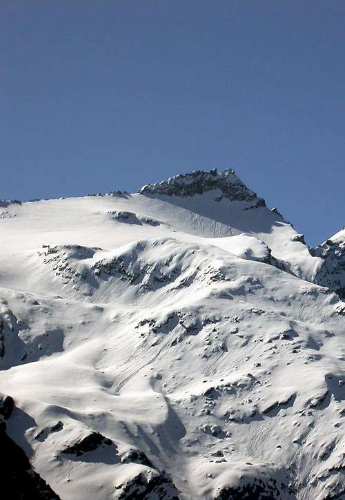
Punta Cissetta N Side
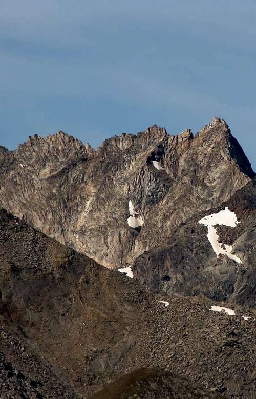
Punta Cissetta E Side
From the parking of Valnontey (1.678m) to move towards the South via the route n° 22/TVC and, beyond the sign ban for cars, reach the "Camping Gran Paradiso" at the Pasture of Bovaz (1.675m); this may easily reach the crossroads 1.687 meters (left or East deviation secondary to the Vallon of Grandzetta) and continue along the main path at the side of the side of the basin left Torrent de Valnontey. After reaching a Unnamed Pasture (1.709m) continue to the next David (1.721m) and the much more important than Vermianaz (1.729/35m). From this point, more precisely from the footbridge that preceding the small village, leave the main path and a secondary and rather steeply to reach the Southeast Alp Valletta (2.090m; beautiful fountain); continue through traces not always apparent on the right side bank of the Torrent Valletta reaching the terminal moraine of Glacier Valletta. Turning to the right (Southeast) of the pond 2868 meters, below the Hill of Valmiana or Vermianaz (3.093m) to abandon the track towards the latter and reach the glacier in 2.690/2.700 meters altitude. Go through the same lap with semi circular Southeast towards the right leaving an area with crevasses; up the slope with gradual slope (from 30° to 40°) where this ends up against the Northern Ridge. Achieved this through easy and small rocks walking distance to the Summit quickly reach the same (A/F +; 4h'45/5h'15 from Valnontey).
Dal parcheggio di Valnontey (1.678 m) indirizzarsi verso Mezzogiorno tramite il sentiero n° 22/TVC e, oltrepassato il cartello di divieto per le auto, raggiungere il "Camping Gran Paradiso" presso l'Alpeggio di Bovaz (1.675 m); da questo in breve raggiungere il bivio 1.687 metri (a sinistra od Est deviazione secondaria per il Vallone di Grandzetta) e continuare lungo il sentiero principale a fianco del lato idrografico sinistro del Torrent de Valnontey. Raggiunta una prima Alpe innominata (1.709 m) proseguire fino alla successiva di David (1.721 m) ed a quella ben più importante di Vermianaz (1.729/35 m). Da questo punto, più esattamente dal ponticello precedente il piccolo villaggio, abbandonare il sentiero principale e con uno secondario, piuttosto ripido, verso Sudest raggiungere l'Alpe la Valletta (2.090 m; bella fontana); proseguire tramite tracce non sempre evidenti lungo la sponda destra orografica del Torrent Valletta raggiungendo la morena frontale del Glacier Valletta. Passando a destra (Sudest) del laghetto 2.868 metri, sottostante il Colle di Valmiana o Vermianaz (3.093 m) abbandonare la traccia verso questo ultimo e raggiungere il ghiacciaio in altitudine 2.690/2.700 metri circa. Attraversare lo stesso con giro semi circolare verso Sudest lasciando sulla destra una zona crepacciata; risalire il pendio con pendenza progressiva (da 30° a 40°) fin dove questo termina contro la Cresta Nord. Raggiunta questa tramite facili roccette a poca distanza dalla Sommità in breve tempo raggiungere la stessa (A/F+; 4h'45/5h'15 da Valnontey).
Difficulties
From F to F+, with easy but delicate climbing in final part on the rocks just under the Northern Ridge.
Da F a F+, con facile ma delicata salita nella parte finale sulle rocce appena sottocresta.
Equipment
For Mountaineering, preferably with rope for the traverse on the glacier.
Da Alpinismo, meglio se con corda nella traversata del ghiacciaio.
Campings
Wild camping in the Parco Nazionale del Gran Paradiso is strictly forbidden! There are three camping sites very near to Valnontey Village. The most appropriate support point is the Money Bivouac.
Red Tape
Within the borders of the P.N.G.P. (Parco Nazionale del Gran Paradiso), at the moment (summer 2004), dogs generally are not allowed, except on a couple of trails, and camping is forbidden (except for climbers from sunset till dawn). No fees are due.
Mountain Condition
Meteo: you can find all the needed informations at the official site of the Valle d'Aosta Region:
"Guida delle Alpi Occidentali", di Giovanni Bobba e Luigi Vaccarone C.A.I. Sezione di Torino Volume II (parte II), 25 Maggio 1896.
"Guida della Regione Autonoma Valle d'Aosta", di Mario Aldrovandi; Ed. S.P.E. di Carlo Fanton, Torino 1964.
"Rifugi e bivacchi in Valle d'Aosta", di Cosimo Zappelli aggiornata da Pietro Giglio, Musumeci Editore, Luglio 2002.
"Guida dei Monti d'Italia-Gran Paradiso Parco Nazionale" E. Andreis, R. Chabod, M. C. Santis, Club Alpino Italiano/Touring Club Italiano, prima Ed. 1939; seconda Ed. 1963; terza Ed. 1980.
"Il Parco Nazionale del Gran Paradiso (Valli di Champorcher-Clavalitè-Saint Marcel-Laures-Cogne-Valsavarenche-Conca di Pila", di Giulio Berruto 3/volume 2°, IGC Torino; prima Ed. 1981; seconda Ed. 2000 (in Italian).
"Gran Paradiso", A. Gegenfurtner, G. Klotz, F. Müller, Ed. Bergverlag Rudolf Rother, Monaco 1980 (in tedesco).
"Gran Paradiso", G. Klotz, Ed. Bergverlag GmbH Rother, Monaco 2005 (in tedesco).
"Gran Paradiso", di Pierandrea Mantovani e Renato Misischi, Ed. Rassegna Alpina, 1974.
"Gran Paradiso-Itinerari Alpinistici e Sci Alpinistici", di Franco Brevini, Ed. Musumeci, Giugno 1982.
MAPS:
Kompass "Gran Paradiso Valle d'Aosta Sentieri e Rifugi" Carta Turistica 1:50.000.
SIRIO Blue Vision "Cogne Valnontey" Carte fotografiche.
Parents refers to a larger category under which an object falls. For example, theAconcagua mountain page has the 'Aconcagua Group' and the 'Seven Summits' asparents and is a parent itself to many routes, photos, and Trip Reports.

 4643 Hits
 86.37% Score
 22 Votes