
-
 1454 Hits
-
 79.04% Score
-
 10 Votes
|
|
Mountain/Rock |
|---|---|
|
|
45.57102°N / 7.44408°E |
|
|
Mountaineering |
|
|
10604 ft / 3232 m |
|
|
Overview
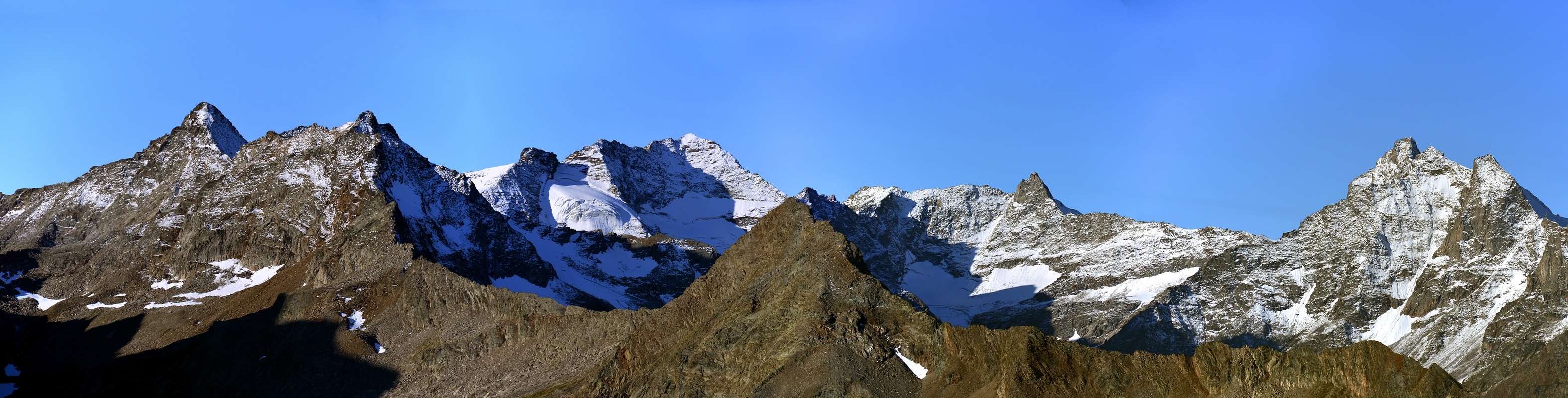
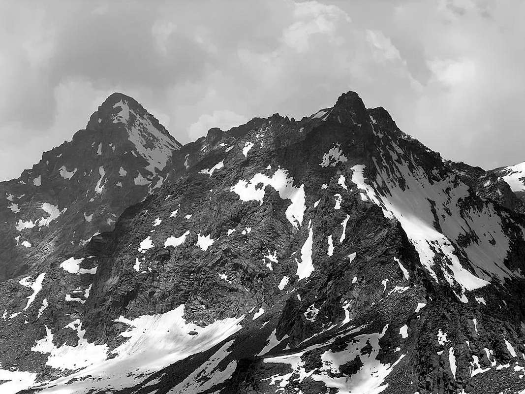
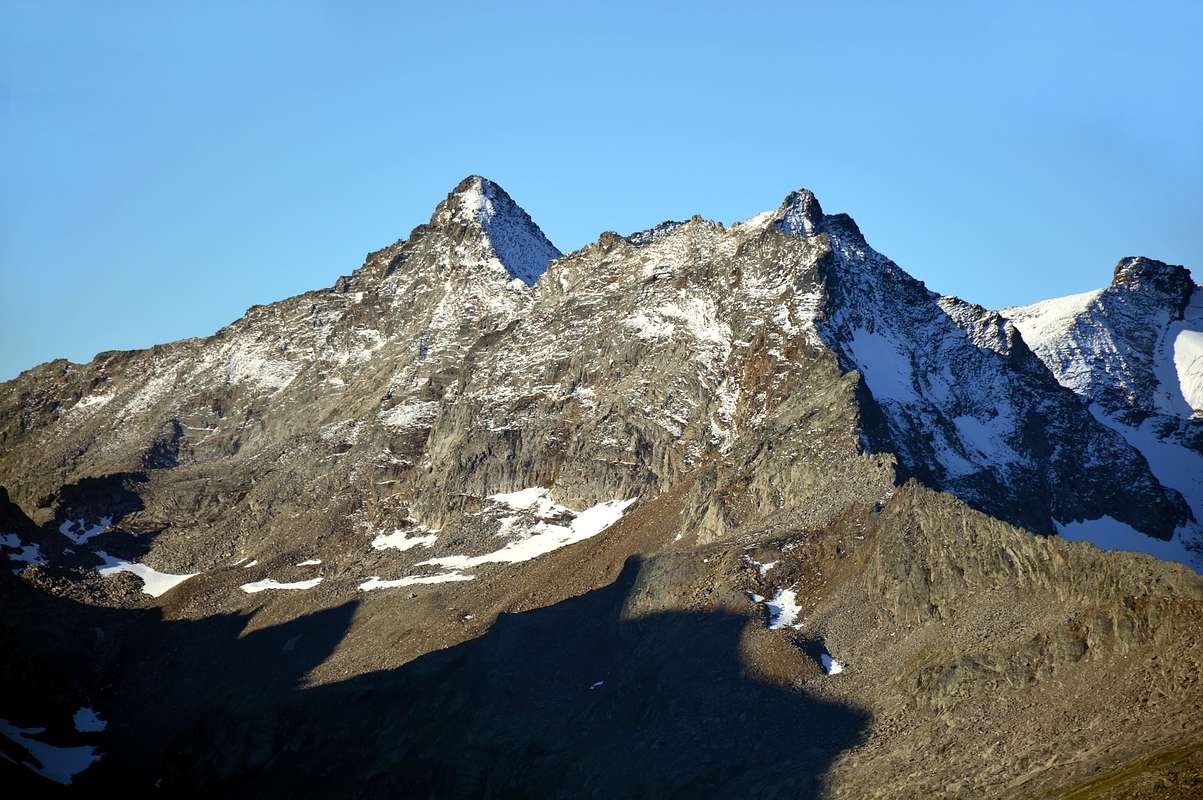
Smart triangular mountain, twin of the nearby duet: Grande Arolla (3.246m), Punta di Forzo (3.296m) and Monveso di Forzo (3.322m), so much so that in the past it was confused with the second being the third the highest of the trio for which it this last was wrong and surely erroneus called Grande Arolla. In full sight from Gimillan (1.787m), just above Cogne Municipality and along the road leading to Lillaz Hamlet (1.617m) near Champlong Village (1.600m). As see and read in the Guide of the "Gran Paradiso National Park" points out; page 507; Ediz. Milan September 1980, about the Punta di Forzo. Although apparently it may seem like a shoulder of the Grande Arolla, this beautiful triangular-looking mountain, when viewed from the Northwest, has its own autonomy that makes it "independent" above the Arolla Glaciers (to the West) and Lavinetta (to the East ). In fact, its three crests head towards:
a) - the North Crest, which coincides with the current Via Normale and which climbs up from the Arolla Hills (2.892 m) and Petite Arolla (2.838 m) surmounting the altitudes 2.920, 2.931, 2.875 meters up to Colle della Petite Arolla and then the altitudes 2.998, 2.994, 3.083, 3.065, 3.105 meters in the second section, which leads to Vetta;
b) - in the direction of the Grande Arolla the Southern Crest which joins the Northern Crest of the Grande Arolla, formed the notch 3.222 meters between the two.
c) - A third ridge descends towards the West, parallel and in sync with that of the Grande Arolla; it plunges into the Northern Arolla Glacier by dividing it with a small circular and glacial amphitheater at the foot of its South Wall as well as the North Face of the Grande Arolla. The same gives birth to the west-northwest of a steep spur just outlined in the right-hand extremity of the Nordovest Wall. A ridge, this Western one, that seems to have already been covered in the past, but in the terminal part as it happened in August 1892; while the basal spur, that flanks it, entering after almost two thirds of the way on the same, appears to have been climbed only once in the July 1983. As for the walls or, better, simply the slopes, it should be noted that they do not offer excellent climbs and, perhaps, the only interesting one can be the one traveled by the 15 August 1937 roped party (Calosci-Ourlaz-Vuillermoz) which
d) -, starting from the Casolari (Bardoney's High Pasture) di Bardoney and heading towards the hill of the same name, they reached the base of the East Wall attacking it under a band of blackish rocks on the left of a gully that descends from a depression between the Top and the nearby antesummit. A reddish rocky jump required a piton (IV°?), Which the first climbers defined as delicate but circumventable, for a total of 4h'30. It should be noted that the Eastern Side is actually divided into two parts, with a second facing NE and divided from the previous one by a great rocky ridge. We will analyze this at the end of our description in a clockwise direction.
e) - The nearby South Wall is of low height and was traveled downhill by the first climbers of August 1892 reaching the small glacial cirque inserted between the two Arollas; it does not require forced passages, being practicable in every sector through very rotten or even crushed rock.
f) - Proceeding towards the Arolla Glaciers we find the triangular NW Wall which, even if the first climbers traveled it in the first part and then diverted upwards on the Western "Crestone", does not present excessive difficulties, so much so that it was covered downhill completely up to the Northern Glacier by the roped of Ferragosto 1937. The same is composed of broken rocks alternating with snow plates in the initial part and then through mixed rock and ice channels and finally rocky plates that are not difficult, but which require some attention
g) - Finally, returning to the Eastern side, the narrow NE Face suspended above the Lavinetta Glacier and projected towards the Col de la Petite Arolla. It appears climbed, perhaps, on a single occasion, such as the adjacent route of 1937, while the route is carried out on its Western extreme margin just under the roughness of the North Crest or Via Normale. You first go up a gully on the right of large rocky plates, formed by debris or by a long tongue of snow; the same, about halfway along the route, wedges, leaving on the left a semicircular ledge convex at the top which gives the possibility of making a "loophole" on the Eastern Crest, in a stretch of more difficult rocks below the final rocky castle which is not excessively difficult, but not easy either (II°/II°+ with two short, but challenging, passes of III°-).
a) - la Cresta Nord, coincidente con l'attuale Via Normale e che risale dai Colli dell'Arolla (2.892 m) e della Petite Arolla (2.838 m) sormontando le quote 2.920, 2.931, 2.875 metri fino al Colle della Petite Arolla e poi le altitudini 2.998, 2.994, 3.083, 3.065, 3.105 metri nel secondo tratto, che conduce in Vetta;
b) - in direzione della Grande Arolla la Cresta Meridionale che si riunisce a quella Settentrionale della Grande Arolla, formato l'intaglio 3.222 metri tra le due.
c) - Un terzo crestone scende verso Ovest, parallelo ed in sincronia con quello della Grande Arolla; si immerge nel Ghiacciaio Settentrionale di Arolla facendo da divisorio con un piccolo anfiteatro circolare e glaciale ai piedi della sua Parete Sud nonché di quella Nord della Grande Arolla. Il medesimo partorisce verso Ovest-nordovest un ripido sperone appena delineato nell'estremità di destra della Parete Nordovest. Una cresta, questa Occidentale, che pare già essere stata percorsa nel passato, ma nella parte terminale come avvenuto nell'agosto del 1892; mentre lo sperone basale, che l'affianca inserendosi a quasi due terzi del percorso sulla medesima, risulta essere stato salito un'unica volta nel luglio 1983. Per quanto concerne le pareti o, meglio, semplicemente i versanti, da annotare come i medesimi non offrano eccelse arrampicate e, forse, l'unico interessante può essere quello percorso dalla cordata del Ferragosto 1937 (Calosci-Ourlaz-Vuillermoz) che
d) -, partendo dai Casolari di Bardoney ed indirizzandosi verso l'omonimo colle, raggiunsero la base della Parete Est attaccandola sotto una fascia di rocce nerastre sulla sinistra di un canalino discendente da una depressione tra la Vetta e la vicina antecima. Un salto roccioso rossastro richiese un chiodo (IV°?), che i primi salitori definirono delicato ma aggirabile, per un totale di 4h'30. Da evidenziare come il Versante Orientale sia in realtà diviso in due parti, con una seconda rivolta a NE nonché divisa dalla precedente da un crestone. Di questa faremo l'analisi al termine della nostra descrizione in senso orario.
e) - La vicina Parete Sud é di scarsa altezza e venne percorsa in discesa dai primi salitori dell'agosto 1892 raggiungendo il piccolo circo glaciale rappreso tra le due Arolle; non richiede passaggi obbligati, essendo percorribile in ogni settore tramite roccia molto rotta od addirittura frantumata.
f) - Procedendo verso i Ghiacciai di Arolla troviamo la triangolare Parete NO che, anche se i primi salitori la percorsero nella prima parte per poi deviare in alto sul Crestone Ovest, non presenta soverchie difficoltà, tanto che venne percorsa in discesa in modo completo fino al Ghiacciaio Settentrionale dalla cordata del Ferragosto 1937. La medesima é composta da rocce rotte alternate a placche di neve nella parte iniziale e poi tramite canalini misti di detriti o roccia e ghiaccio ed infine placche rocciose non difficili, ma richiedenti una certa attenzione.
g) - Infine, ritornando sul lato Orientale, la stretta e sbilanciata sulla destra (Ovest) Parete NE sospesa sopra il Ghiacciaio di Lavinetta nonché proiettata in direzione del Col de la Petite Arolla (2.838 m). Risulta salita, forse, in un'unica occasione nel luglio del 1983, come l'adiacente via del Ferragosto 1937, mentre il percorso viene svolto nel suo margine Occidentale sotto delle asperità della Cresta Nord o Via Normale. Si sale dapprima per un canalone sulla destra di grandi placche rocciose, formato da detriti oppure da una lunga lingua di neve; la stessa, a circa metà del percorso, si incunea, lasciando sulla sinistra una cengia semicircolare convessa in alto che concede la possibilità di effettuare una "scappatoia" sul Crestone Est all'altezza di 3.100/20 metri circa, in un tratto di rocce più difficili sottostanti il castelletto roccioso finale non eccessivamente difficile, ma neppure facile (II°/II°+ con due brevi ma impegnativi passaggi di III°-).
First Ascents
- First on the Summit (N-W Wall and W Arête): Giovanni Bobba, L. Gadin and Eliseo Jeantet, (Aug 01th, 1892).
- In winter: Giuliano Calosci and A. Piatto, (winter 1924?); starting from Lillaz Hamlet.
- N Arête (Normal Route): unknown; in ascent from the Western or Eastern Slopes of Col de l'Arolla or from the Northwestern Slope of Col de la Petite Arolla.
- W-NW Spur and W Crest in final part: Osvaldo Cardellina, lone, (Jul 10th, 1983), in ascent from Lillaz, Valeille, Arolla Pastures, P.N.G.P. Cabine, North Glacier; with traverse to Grande Arolla by North Crest. In descent through Southern Crest to Col des Murailles Rouges Western Slope on Arolla Southern Glacier to Northern, Arolla, Valeille Pastures, Lillaz.
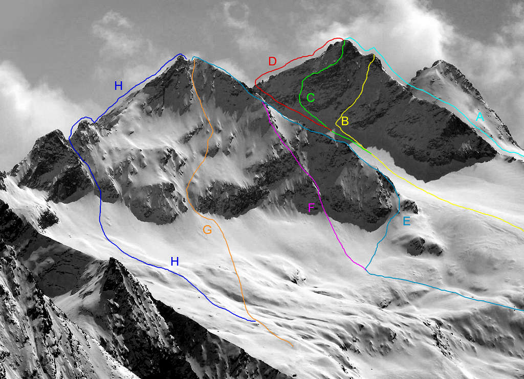
- NW Wall (Diagonal Via) and West Crest in final part: Giovanni Bobba, L. Gadin and Eliseo Jeantet, (Aug 01th, 1892); in ascent from Lillaz Hamlet, Valeille and Arolla Pastures, Northern Arolla Glacier.
- NW Wall: Giuliano Calosci, Giulio Adolfo "Dulo" Ourlaz and Pierino Vuillermoz, (Aug 15th, 1937), in descent to Arolla North Glacier, Arolla, Vieille Alps, Lillaz.
- NE Face (Right Couloir and rocky final Castle): Osvaldo Cardellina and Marco Cossard, (Jul 16th, 1983), in ascent from Lillaz, Bardoney Pasture, NW shore of Lavinetta Glacier; with traverse to Grande Arolla by Northern Ridge and in descent through South Crest to Col des Muralles Rouges East Slope on Bardoney Vallon towards Plan des Goilles, Loie Loch and Alp, Quarteret-Lillaz Villages.
- E Wall: Giuliano Calosci, Giulio Adolfo "Dulo" Ourlaz and Pierino Vuillermoz, (Aug 15th, 1937); in ascent from Lillaz Village, Bardoney Pastures and Vallon.
- S Wall: Giovanni Bobba, L. Gadin and Eliseo Jeantet, (Aug 01th, 1892); in descent from the Summit.
- N Arête (Integral traverse): Osvaldo Cardellina, Christian Cardellina, Alessandro Cardellina and Marco Cossard, (Jun 20th, 1985), in ascent from Lillaz, Valeille Alp, East Slope of Col de l'Arolla, crossing Piccola Grande Arolla through both North Ridges; in descent by S-SO Ridge to Murailles Rouges Pass.
Getting There
BY CAR:
- From Torino, Milano, etc: Motorway A5. Exit at Aosta Ovest. Drive to the near Aymavilles. Follow the directions for Valle di Cogne.
- From Switzerland: through the Grand Saint Bernard Tunnel or the namesake Pass. Drive to Aosta, then follow the direction for Courmayeur on SS.26. Just after Sarre, turn to the left, in the direction of Valle di Cogne.
- From France: through Mont Blanc Tunnel or Petit St. Bernard Pass. It isn't necessary to take Motorway A5: you can drive on SS.26, in the direction of Aosta. Before arriving at the Village of Sarre, turn right following the sign for Valle di Cogne. After Aymavilles, the Regional Road n°47 crosses the Villages of Vieyes, Epinel and Cretaz and after about 25 Km arrives at Cogne (1.534m). From Cogne you can get the Village of Lillaz (1.617m).
BY PLANE:
- Aeroporto "Corrado Gex" Saint Christophe (Aosta).
Approach & Route with traverse from South to the North and viceversa
A) - Starting from Cogne (1.534m) you must arrive (bus or car) to the car parking of Lillaz (1.617m). Start ascending along the path pointing to Valeille Valley, after a terrace follow up to a bridge near a big boulder. Cross the bridge and follow the mule track till the fork leading to the Arolla Hut of Gran Paradiso National Park, on along some steep hairping to reach the terrace hosting the hut (2.259m). Now follow for the Arolla Glacier passing to the right a crevassed bump, then keep the center of the glacier, limited by the Arolla Summits and the Punta di Forzo, to get the Colle di Muraille Rouge (3.183m) paying attention to the bergschrund. Climb the big stones of the ridge (I°+) and, once on the summit of the Grande Arolla (3.296m) start the short and jagged ridge (some exposure and some not easy passages on rock : III°-) leading to the summit of the Piccola Arolla (3.232m) (6h'00/6h'30 hours from Lillaz).
Descent: Coming down along the same route.
A) - Dall'abitato di Cogne (1.534 m) in bus o in auto, raggiungere la ridente Frazione di Lillaz (1.617 m), dove si parcheggia nel grande piazzale sito quasi al centro del villaggio. Iniziare la salita imboccando il sentiero che si dirige nel Vallone di Valeille; dopo aver superato un gradone, si prosegue sino a un ponte sito a breve distanza di un grande macigno. Dopo averlo attraversato, continuare lungo la mulattiera sino al bivio che conduce al Casotto "Arolla" del Parco Nazionale del Gran Paradiso; risalire il sentiero per ripidi tornanti sino a raggiungere la capanna posta su uno spalto (2.259 m). Proseguire sino al Ghiacciaio dell'Arolla superando sulla destra una "gobba" crepacciata. Continuare la salita tenendosi al centro del ghiacciaio racchiuso fra le due Arolle e la Punta di Forzo; raggiungere il Colle di Muraille Rouge (3.183 m) facendo attenzione alla crepaccia terminale. Risalire la cresta su grandi blocchi (I°+) e, toccata la vetta della Grande Arolla (3.296 m), iniziare la traversata della breve e frastagliata cresta (con passaggi esposti e abbastanza impegnativi; III°-) che conduce alla vetta della Piccola Arolla (3.232 m) (ore 6h'00/6h'30 da Lillaz).
Discesa: Per la stessa via di salita.
Descent: Coming down along the same route, else crossing to Grande Arolla with down-hill through the itinerary A.
Discesa: Per la stessa via di salita, oppure traversando verso la Grande Arolla e discesa con l'itinerario A.
1) - from Colle di Arolla, reached from the West or Valeille side or from the East side from Bardoney, head S-SE overcoming the altitudes 2.998, 2.994, 3.083, 3.065 meters up to Colle della Petite Arolla and continue from there. Otherwise
2) - having reached this notch 2.838 m continue further towards the South, passing in succession the altitudes 2.920, 2.920, 2.875 meters until it joins with itinerary
B) - above. In both cases foresee a climb, as well as longer, certainly more demanding with the overcoming on the edge of the ridge (II°/II°+ also III°-/III°) or with small bypasses on the Eastern Side; in this last case, pay close attention due to poor quality of the rock, even in the presence of very dangerous grass. The ascension with relative crossing becomes complete and with a circular tour starting from the Colle di Arolla and descending from that of the Muraille Rouge.
VARIANTE: é possibile, inoltre, allungare il percorso di circa oltre 1 kilometro partendo dal Colle di Arolla (2.892 m), oppure di circa 650 metri con inserimento da quello della Petite Arolla (2.838 m). Nel primo caso
1) - dal Colle di Arolla, raggiunto dal Versante Ovest o di Valeille oppure da quello Orientale dal Bardoney, dirigersi a S-SE superando le quote 2.998, 2.994, 3.083, 3.065 metri sino al Colle della Petite Arolla e da questo continuare. Altrimenti
2) - raggiunto questo intaglio 2.838 m, proseguire maggiormente verso Meridione superando in successione le quote 2.920, 2.920, 2.875 metri fino a congiungersi con l'itinerario
B) - di cui sopra. In entrambi i casi prevedere un'arrampicata, oltre che più lunga, sicuramente più impegnativa con il superamento sul filo di cresta (II°/II°+ anche III°-III°) oppure con piccoli aggiramenti sul Versante Orientale; in questo ultimo caso prestare molta attenzione a causa di non buona qualità della roccia, anche inpresenza di erba molto pericolosa. L'ascensione con relativa traversata diventa completa e con giro ad anello iniziando dal Colle di Arolla e scendendo da quello della Muraille Rouge.
This route can be considered AD-.
Questo percorso può essere considerato AD-.
Classic for high mountain routes: rope, helmet, iceaxe, crampons.
Classica per le vie d'alta montagna con corda, elmetto, piccozza e ramponi.
Red Tape
Within the borders of the P.N.G.P. (Parco Nazionale del Gran Paradiso), at the moment (summer 2004), dogs generally are not allowed, except on a couple of trails, and camping is forbidden (except for climbers from sunset till dawn). No fees are due.
Campings
- Wild camping in the Parco Nazionale del Gran Paradiso is strictly forbidden!!!
Mountain Condition
- You can get meteo information at the official site of the Regione Valle d'Aosta:
- Valle d'Aosta Meteo
Webcam
- WEBCAM on Aosta Valley:
- Webcam
Books & Maps
BOOKS:- "Guida delle Alpi Occidentali" di Giovanni Bobba e Luigi Vaccarone C.A.I. Sezione di Torino Volume II (parte II), 25 Maggio 1896.
- "Gran Paradiso" di Pierandrea Mantovani e Renato Misischi, Ed. Rassegna Alpina, 1974.
- "Diari Alpinistici" di Osvaldo Cardellina e Indice Generale accompagnato da Schedario Relazioni Ascensioni 1964-2019 (inediti).
- "Gran Paradiso" A. Gegenfurtner, G. Klotz, F. Müller, Ed. Bergverlag Rudolf Rother, Monaco 1980 (in tedesco).
- "Gran Paradiso" G. Klotz Ed. Bergverlag GmbH Rother, Monaco 2005 (in tedesco).
- "Gran Paradiso - Itinerari Alpinistici e sci Alpinistici" di Franco Brevini Ed. Musumeci, Giugno 1982.
- "Il Parco Nazionale del Gran Paradiso (Valli di Champorcher-Clavalitè-Saint Marcel-Laures-Cogne-Valsavarenche-Conca di Pila" di Giulio Berruto 3/volume 2°, IGC, Torino 1981, 2a Ed. 2000. (in Italian)
- "Guida dei Monti d'Italia-Gran Paradiso Parco Nazionale" E. Andreis, R. Chabod, M. C. Santis, Club Alpino Italiano/Touring Club Italiano, prima Ed. 1939; seconda Ed. 1963; terza Ed. 1980.
 |
 |
 |
 |
- Kompass "Gran Paradiso Valle d'Aosta Sentieri e rifugi" Carta turistica 1:50.000.
- I.G.C. Istituto Geografico Centrale "Gran Paradiso-La Grivola-Cogne" Carta turistica 1:25.000.
- A.IA.T "Cogne Gran Paradiso Cogne Aymavilles-Walking map" 1:25.000.
- L'Escursionista "Valle di Cogne Carta dei Sentieri" (n° 10) 1:25.000.
- L'Escursionista "Tour de la Vallée de Cogne Grand Paradis" Carta dei sentieri 1:25.000.
Important Information
- REGIONE AUTONOMA VALLE D'AOSTA the official site.
- FONDAZIONE MONTAGNA SICURA Villa Cameron, località Villard de la Palud n° 1 Courmayeur (AO) Tel: 39 0165 897602 - Fax: 39 0165 897647.
- SOCIETA' GUIDE ALPINE DI COGNE Tel. 347/9473526 – 328/1373728.
- A.I.NE.VA. (Associazione Interregionale Neve e Valanghe).
- A.IA.T. Cogne Gran Paradis via Bourgeois n° 34 Tel. 0165-74040. E-mail: aiat@cogne.org
- Ezio Sport articoli sportivi - via Bourgeois n° 64 Tel. 0165-74204.
Useful Numbers
- Soccorso Alpino Cogne (SAR) Tel. 3482685406.
- Protezione Civile Valdostana località Aeroporto n° 7/A Saint Christophe (Ao) Tel. 0165-238222.
- Bollettino Meteo (weather info) Tel. 0165-44113.
- Unità Operativa di Soccorso Sanitario Tel. 118.
Acknowledgements
I am greatly indebted to my friend "Osva" for the translation of the text from italian.