

-
 38615 Hits
-
 95.51% Score
-
 53 Votes
|
|
Mountain/Rock |
|---|---|
|
|
38.38281°N / 112.81478°W |
|
|
Beaver |
|
|
Hiking, Trad Climbing, Sport Climbing, Toprope, Bouldering, Scrambling |
|
|
Spring, Summer, Fall, Winter |
|
|
9580 ft / 2920 m |
|
|
Overview.
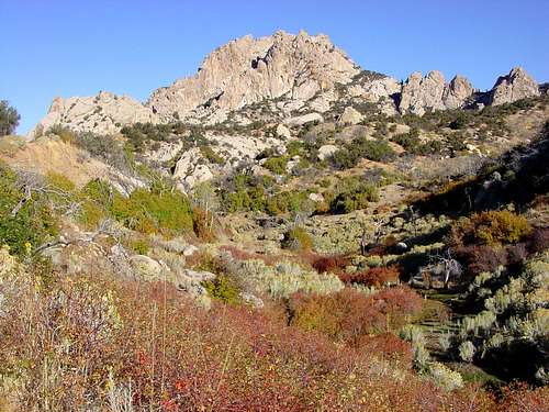
Granite Peak is a gorgeous and unknown gem in the southwest portion of Utah located near the small community of Milford. Incredible rugged granite spires, boulders and pinnacles make up this portion of the Mineral Range where the mountain resides. Pumice mines and quarries dot the lower flanks of the mountain, in the midst of cedars, spruces, pines and aspens. Seemingly known mainly to the local populations of Milford and Beaver, the mountain is rich in opportunities for those seeking different forms of outdoor recreation ranging from hiking, various forms of climbing, bouldering and exploring the endless nooks and crannies which are everywhere.
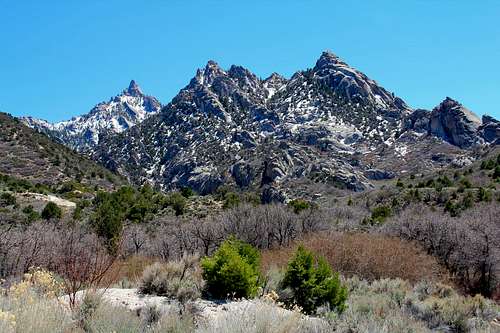
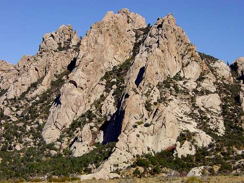
A look at Granite Peak and the Milford Needle from the north.
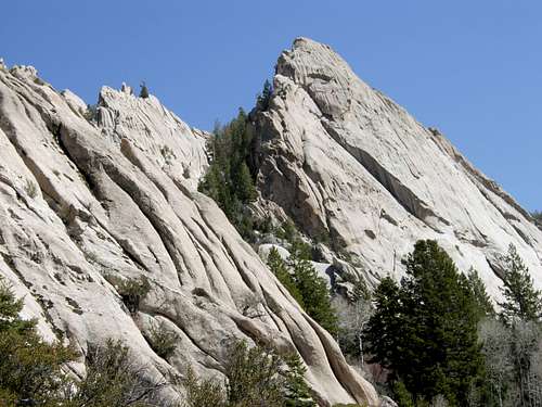
View of the Milford Needle and lower towers from the north west.
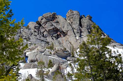
The north face of the Milford Needle.
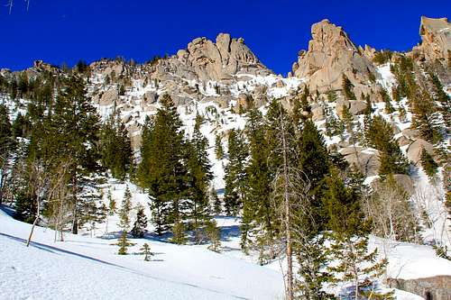
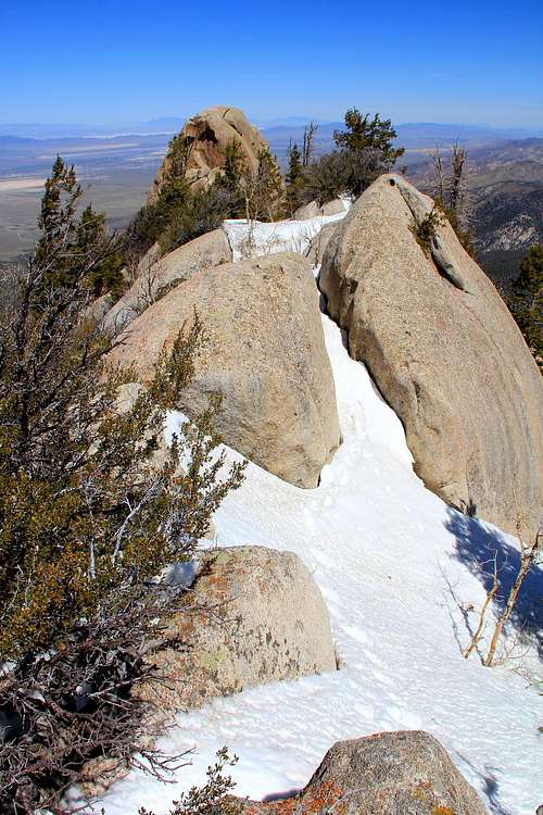
Up on the North Slopes approach, looking up at the summit ridge area.
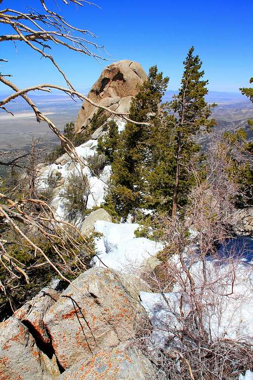
From the summit looking north along the ridge at the Milford Needle.
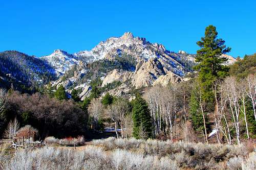
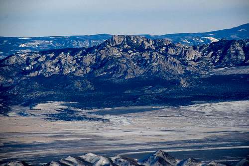
Granite Peak seen from the north
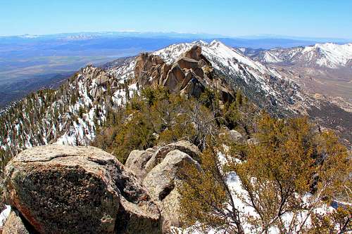
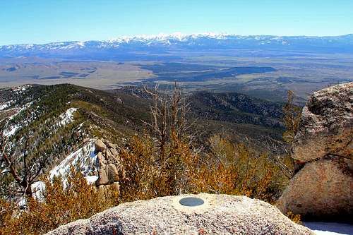
South view from the summit.
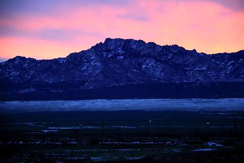
A look at Granite Peak from Milford on a cold January morning.
Getting There.
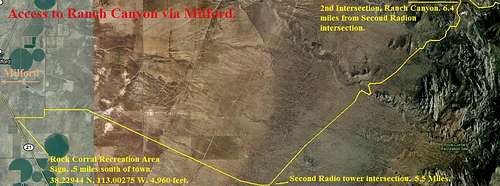
The main access to the mountain is located at and around Milford, Utah. Milford is a smaller community located west of Beaver, Utah roughly 20 miles. To get to Milford from Beaver, which is just off I-15, take exit 112 from either the north or south approach. Proceed into Beaver, which is on the east side of I-15 to Center Street. At Center Street, head west out of town. You will be on Highway 21 at this point. From Beaver you will drive 30 miles around the south side of the Mineral Range to Milford. Once arriving in Milford the Mineral Range and the Granite Peak area will stand out in rugged fashion.
There are several different ways to access the Mineral Range from Milford. The road described here is definitely the most scenic. The road is graveled dirt, passable by most passenger vehicles. The access point for this road is about a half mile before entering town from the south, and is due east of Highway 21 with a sign labeled "Rock Corral Recreation Area." This road leads straight east past two radio towers. To access the normal route in Ranch Canyon, there is an intersection at the second radio tower on this road, which is 5.5 miles from the turn off on Highway 21.
Turn left at this intersection, and drive in a north east direction another 6.4 miles from the second radio tower intersection. At 6.4 miles you will end up at another intersection, and will have driven past some stellar scenery of Granite Peak directly above you to the east. This intersection links up with another dirt road heading west back out of the range towards town, and to the east continuing up Ranch Canyon.
Take a right here, and continue up into the canyon 2.1 miles on a surprisingly good dirt road heading in a north east direction. Once thing to note here is that the road does cross the stream three to four times. A high clearance vehicle will help with these stream crossings, especially during this height of run-off during Spring months with higher levels of melt water from above.
The road heads off toward the head of Right Fork of Ranch Canyon, around South Twin Flat Mountain's north side. You will pass two summer homes to the start of the North Slopes approach route trail head, located just about 200 yards south of the last summer home in a shaded parking area. WGS84 GPS coordinates for this location are: 38.24300 N, 112.48639 W, at 7,100 feet.
Road access map for Ranch Canyon from Milford.
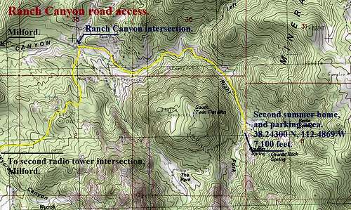
Road access map for Ranch Canyon to the start of the "North Slopes" route.
Red Tape.
Most of the Mineral Range is BLM land, however there are a few things to keep in mind while out there.
Private Property.
As seen in the approach description and photos, there are a few properties that dot the terrain. The two summer homes in Ranch Canyon are an example of this, please respect these properties by avoiding any trespassing.
Road Conditions.
The Mineral Range access roads normally are well maintained, however during the winter season you will be limited in reaching the higher portions of the mountain due to snow. Plan on this accordingly, as you may have two to three miles one way to add to the route by starting from a lower point on the mountain. One other thing is during the Spring season when the streams running through the canyon are at higher levels. There are several stream crossings in Ranch Canyon which will have to be crossed. Normally a higher clearance vehicle can pass these. There are two or three sections where the stream literally erodes the road away by cutting deeply into the road. Use discretion when crossing these portions, some of these cuts are very deep and will easily high center your vehicle.
Camping.
Developed Camping.
The Rock Corral Campground located on the south west side of the Mineral Range offers year round access, no fees, and lavatories. The campsites here are limited to two locations, and are on a first come/first serve basis. There is no running water located at the Rock Corral area. This campsite is operated by the BLM. To get to the campsite from Beaver travel on HWY 21 to Milford Utah approx 30.4 miles. Just 1/2 mile before Milford you will see a sign marking the Rock Corral Canyon turn off. This road is called Pass Rd. Travel for approx 2 miles to a fork in the road. The right fork will take you to the Rock Corral Recreation Area and the left to Ranch Canyon. Check out the Utah Outdoor Activities site for the Rock Corral area here.
At large camping.
The Mineral Range has an abundance of off site camping areas along the roads, with fire rings and areas for tent camping. A short side trip up one of the smaller canyons can lead to more secluded campsites if that's your niche.
When to climb and gear.
The Mineral Range can be accessed year round. The temperatures here range largely from season to season.
Summer.
The summer season in the area is very hot. Plan on lots of sunscreen and a good hat for sun protection. The routes up to the summit all are on steep slopes involving a good amount of scree and several different species of brush that will tear you apart, long pants are recommended. A good rugged set of boots and trekking poles will help during this time.
Spring.
The north side of Granite Peak hold's a good amount of snow at the higher elevations, during my climb up in the first part of May 2010 the snow conditions were prime with solid consolidated snow. An ice axe is recommended for the steep slopes higher up near the summit ridge. Crampons aren't needed unless you feel more comfortable wearing them. Kicking steps up higher will be needed, a good solid set of boots will work. If approaching the summit from the south that side of the mountain is usually free of snow during the spring season.
Fall.
The Fall season is probably the best time of year to hit the area up. Fall temperatures can range from fairly warm during the day to freezing at night, plan on a good jacket and pants during this time.
Winter.
During the Winter season the temperature drops surprisingly low in this area. Snowshoes or skis will be needed for the approach to the mountain with the snowpack blocking access to the main trail head area. The north side of the mountain will be loaded with fresh powder/sugar snow and may not be the best approach.
North Slopes Route Information
The most straight forward route up Granite Peak is from the North Slopes above Ranch Canyon. See the "Getting There" section to access the trail head. There are no trails up this route other than a faint climber's use trail which meanders above the stream at the head of Ranch Canyon. A good portion of the route involves a good amount of bushwacking unless approaching the summit during the dead of winter when snow covers a lot of the vegetation.
North Slopes Approach.
One way mileage: 1.8 miles.
Elevation gain: 2,480 feet.
Class 2 and 3.
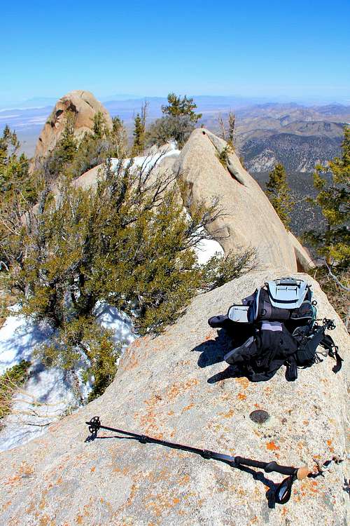
Begin at the parking area just south of the second summer home, making your way in a south direction. The dirt road leads up and over a ridge to the west into an area called "The Park." Follow the dirt road from the parking area for about a third of a mile, then cut off the road to the left heading due south up the canyon. Soon you'll be following a use trail of sorts, and the canyon narrows to the stream bed fairly quickly after another third of a mile. The use trail mainly is found on the east side of the stream, crossing for two short sections through the narrow canyon to the west. After half a mile through this canyon the terrain opens up and you will have your first pristine view of the north side of Granite Peak and the Milford Needle. From here it is a matter of using route finding skills up the through the granite blocks and buttresses to the summit ridge. Prepare for dealing with some knee-deep brush to bushwack through during the drier seasons. It is best to head up the north slope of this portion in a south west direction to just under the summit of Granite to avoid getting cliffed out on the ridge from the east. There is a limited window of opportunity just below the summit area on the ridge. The summit of Granite is found on the highest portion of the ridgeline and is marked with two triangulations markers and the benchmark on the top of a large granite boulder. A broken wire fence is found here and there around the summit blocks.
Thanks to SP member kmenden for the following information:
* North Slopes GPS Trailhead parking area coordinates: 38.4045 N, -112.8062 W
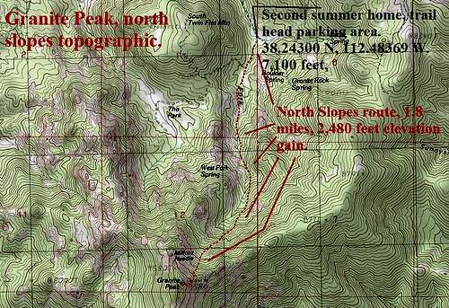
Topographic for the North Slopes route up Granite Peak. Route in red.
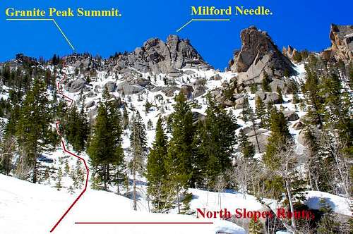
The upper portion of the North Slopes route, in red.
The summit and one of the triangulation markers. Milford Needle in the distance.
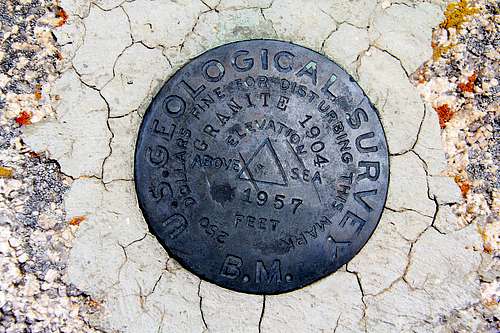
The benchmark.
Southwest Route Information
The Southwest Route starts from Rock Corral Picnic Area. It can be reached by any vehicle in dry weather. I should start out by saying that this route is hard to describe. It requires route finding around many large cliffs and fighting your way through bushes, trees, and other vegetation. The book, Utah Mountaineering Guide by Michael R. Kelsey does a good job though. I will add to what he wrote with my own observations.
Southwest Route Approach
One way mileage: 2.1 miles
Elevation gain: 2,522 feet
Class 3
I began by hiking up a canyon that headed southeast from the parking area angling toward the right. You’ll want to hike up to the area located below the west face of Geode Dome. It is hard to miss. Get used to hiking and bushwhacking through the dense brush and trees since this is what much of the route will be like. Once you make it near the dome, you will start heading the other direction, up and to the northeast. I crossed two canyons along the way. Both of them contained running water in late April.
I weaved my way underneath cliffs while hiking north. I made it about halfway up the route but decided to turn around since I needed to get back home. I underestimated the amount of time it would take for this hike. I felt that I was correctly on route the whole time though. I believe that it continues angling up to the left which leads north and then east to the summit. This is a strenuous route to the summit but it travels near cool granite cliffs and domes which is interesting. I would suggest taking the route from the north if you are looking for an easier route.
Southwest Route on Granite Peak
Area weather.
The weather for Granite Peak is based off of that in Milford, Utah. Please check out the most current weather conditions for Milford here.

Geology.
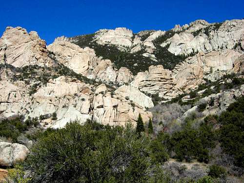
The Mineral Range and Granite Peak have some incredible geological features. The whole composition of Granite Peak is a brittle granite rich in quartz and pumice. This area is the largest batholith in Utah, which is an exposed area of mostly continuous plutonic rock that covers an area larger than 100 square kilometers. These areas are exposed to the surface through the process of erosion accelerated by continental uplift acting over many tens of millions to hundreds of millions of years. This process has removed several tens of square kilometers of overlying rock in many areas, exposing the once deeply buried batholiths.
Batholiths exposed at the surface are subjected to huge pressure differences between their former homes deep in the earth and their new homes at or near the surface. As a result, their crystal structure expands slightly and over time. This manifests itself by a form of mass wasting called exfoliation. This form of erosion causes convex and relatively thin sheets of rock to slough off the exposed surfaces of batholiths (a process accelerated by frost wedging). The result: fairly clean and rounded rock faces.
They are composed of multiple masses, or plutons, bodies of igneous rock of irregular dimensions (typically at least several kilometers) that can be distinguished from adjacent igneous rock by some combination of criteria including age, composition, texture, or mappable structures. Individual plutons are crystallized from magma that traveled toward the surface from a zone of partial melting near the base of the Earth's crust.
One of the unique features in the Mineral Range is the abundance of pumice, the quality of that used in landscaping materials. Several pumice mines and quarries dot the area. When driving around the area keep an eye out for these mines, as the areas are incredibly white compared to the surroundings.
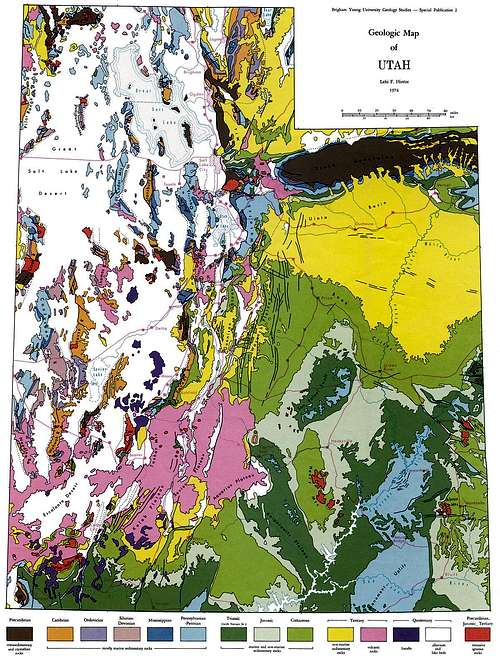
Utah Geologic Relief Map.
An interesting fact on Granite Peak vs. the Milford Needle.
While the factor of prominence comes into play here on this mountain, the benchmark for Granite Peak is located on the summit ridge which appears to be two feet lower than that of the Milford Needle. A few folks out there seeking prominence peaks have headed up Granite Peak, and attempted the Milford Needle to reach the Mineral Range's highest point. Most have been blocked by the sheer granite walls to the top of the Needle, which appear to be YDS 5+ to acquire the "true summit." Keep in mind that this page was created primarily for the benchmark location, and for exploring an incredible area out in one of Utah's less known ranges.
Lists of John states Granite Peak at 9,582 feet, giving it a total prominence of 3,002 feet. 9,582 feet is the altitude listed on the USGS topo map for the Milford Needle. That link for Lists of John can be seen here.
A look at Granite and the Milford Needle from neighboring Frisco Peak.
A look east from the summit with the benchmark atop a large boulder.
This photo shows the Milford Needle in the distance, a mere 2 feet higher.
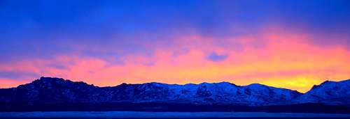
Morningrise over the Mineral Range.
Rock Climbing
When I first visited the Mineral Mountains, I was impressed with the amount of granite domes, buttresses, and spires in the area. Climbers have established routes here. They are mostly a mix of trad and sport. I noticed that there are routes, especially the shorter ones, that are entirely bolted. Some of the routes do not see much traffic and may be loose in nature. The west face of Granite Peak is home to several of the largest domes.
Other areas are located in the valley farther to the west. Geode Dome has some of the longest routes. The best time to climb is in Spring and Fall when the weather is nice. Summer is usually too hot for most people. Winter can get very cold in this valley. One year I was there during October and November and remember it being chilly at night but perfect during the day. There isn’t much detailed information available but I will tell you about the areas that I am aware of.
| MINERAL MOUNTAINS ROCK CLIMBING | ||
| Rock Formation / Area | Route Difficulty | Length |
|---|---|---|
| Geode Dome | 5.9 - 5.10d | Up to 6 pitches |
| Chromozome Dome | 5.9 - 5.12a | 1 to 2 pitches |
| Epoch Dome | 5.11c - 5.13a | 1 to 2 pitches |
| Harvest Dome | 5.8 - 5.12a | 1 to 2 pitches |
| Pioneer Day Buttress | 5.8 - 5.12b | 1 to 2 pitches |
| Melt Down Dome | 5.8 - 5.10c | 1 to 2 pitches |
| Rib Cage | 5.11b - 5.13a | 1 to 2 pitches |
| DLK Powerdome | 5.10b - 5.10d | 1 to 2 pitches |
| Plasma Dome | 5.10a - 5.10b | 1 to 2 pitches |
Mineral Mountains Rock Buttresses
Geode Dome seen from the northwest
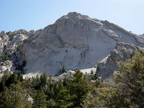
Geode Dome seen from the west