
-
 3178 Hits
-
 83.97% Score
-
 18 Votes
|
|
Mountain/Rock |
|---|---|
|
|
46.89493°N / 13.94037°E |
|
|
Hiking, Skiing |
|
|
Spring, Summer, Fall, Winter |
|
|
7448 ft / 2270 m |
|
|
Overview
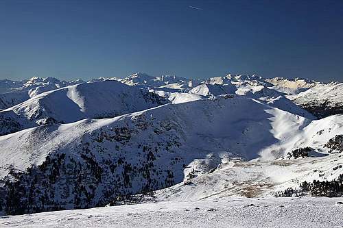
Grosser Speikkofel west views
Intro
I ascended Speikkofel already in winter 2005. I was in hurry that day, conditions were poor, skiing was only possible from Kleiner Speikkofel, 2109 m, the rounded southern fore-summit. Besides some panorama pictures I felt there was nothing much worth posting on SP. Since then, the collection of summits on SP has become more and more comprehensive, so as yesterday with Jasmina we reached the highest summit, it is time to make a small contribution. At the end, it is a nice mountain!
The Name
Mountain has its name by a plant, which is characteristic for the region around Mur valley. That is Speik (Valeriana celtica), known also as celtic baldrian. It grows up to 15 cm and its roots are used for production of aromatic substances (also in soap production).
About Grosser Speikkofel
Speikkofel is a typical "Nock" summit. In southern or northern limestone Alps, summits with such altitude would probably be quite steep and rugged. Not in Nockberge. The mounain looks like a soft, rounded hill, still, due to nice views around, perfect for hiking and in winter and spring even more for skiing. Grosser Speikkofel is one of the easiest ski tours far around, but due to 800 m of altitude difference also one of the more beautiful ones. In summer, there are many marked paths in the area, enabling carefree visits of the area.
The area of Nockberge ends on the eastern part with the area around Flattnitz. In the northern part of those mountains there are a few summits which are the highest in the whole group: Eisenhut, 2441 m and Wintertalernock, 2394 m. Speikkofel stands south of the main ridge. It is the highest elevation in a long, humble ridge, which runs from Bretthoehe, 2320 m, in the main ridge, towards the south, all the way to the village of St. Lorenzen 1470 m.
The cute church and a few farm houses around - this is the village of St. Lorenzen. It is a perfect trailhead. On a nice, sunny terrace, some 200 m above the valley, you can park your car and start hiking up by the south ridge of Speikkofel. In times of tour skiing, you are usually able to ski down just to the parking place by the church. The whole tour on top is easy and short.
Summit Panorama
The view towards Hochgolling and Dachstein

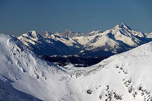
Southern views - Julian Alps in distance
As Grosser Speikkofel is rising on the southern side of the main mountain chain, the views are free only towards the south, east and west. On the east there are the forrested, much lower Gurkatl Alps. Only in the distance the high, barren shoulders of Lavanttal Alps are seen. Towards the south you can see the whole Kaernten. On the horizon there is the sawtooth-like chain of Julian Alps. Towards the west you can first see the hilly landscape of Nockberge, behind them, however, the much higher mountains of Hohe Tauern are rising. As usually in these areas, Hochalmspitze, the indisputed queen of eastern Hohe Tauern is seen as the most elegant mountain. Towards the north the nearby mountains are obscuring the view in distance, only through a notch between Hoazhoehe, 2319 m, and Bretthoehe, 2320 m, the highest part of Niedere Tauern can be seen (around Hochgolling), and, behind that area, the southern walls of Dachstein are rising. A very nice scenery!
Getting There

St. Lorenzen
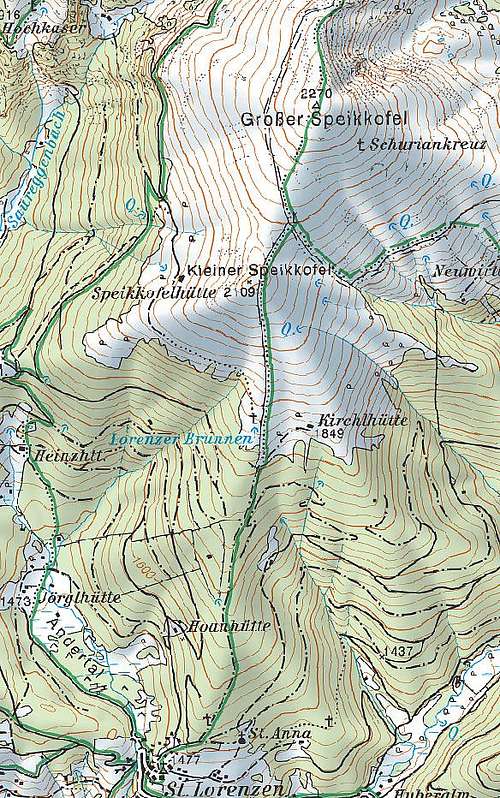
As the most obvious trailhead for the ascent on Speikkofel we already mentioned St. Lorenzen village, 1470 m. You reach it from the main road, which connects Feldkirchen on the south with Turracher Hoehe pass. Driving towards the north you get to Ebene Reichenau, where you deter from the main road towards the east. A narrow asphalt road goes up by the valley some 3 km, then you deter left again and in few turns the access road reaches the parking place by St. Lorenzen church.
The second, but more distant trailheads could be on the road further north to Turracher Hoehe saddle. You could start the tour either on the pass itself (1795 m), or just south of it, depending on itinerary. In any case your hike would lead you far towards the east, crossing the mountain group in the area of its main ridge.
Hike Advices

getting out of woods

On the south ridge
1. From St. Lorenzen - ski tour. From the church you start walking northwards, following a mountain road which is also marked with red Austrian marks. At first you keep right, then from the road a bit steeper cart-road deters left, again in the northern direction. The ascent is easy and not steep, in winter you comfortably walk up on skis. The cart road is broad enough also for later skiing, only if snow is really fast, you will find it steep and too quick for a fast downhill. Through nice woods the ascent lasts about one hour, then we exit out of woods on a place, called Lorenzer Brunnen (water source), 1850 m. On our right there is a shepherds hut, towards the left a path deters to Speikkofelhuette. But we continue along the fence, straight towards the north.
The last trees accompany us by the southern ridge, which is slowly becoming a bit more steep. Still, you always walk up directly, not even switchbacks are needed. The terrain is really humble and now completely opened, offering nice views around. Still, you do quite some distance and to the flat summit of Kleiner Speikkofel, 2109 m, you need another hour. There the view on the main summit opens. You first slide by the north ridge some 30 meters down and then start the final ascent. The southern slopes of the main summit are again a bit more steep. In a few turns we avoid some harmless rocks, reach the summit plateau and soon the highes point. That's another 45 minutes from the fore-summit.
You ski down by the same route.
2. From Turracher Hoehe. From the pass a marked route goes all the time by the main ridge towards the east. It crosses the summits: Schoberriegel, 2208 m, Gruft, 2232 m, Kaserhoehe, 2318 m, Hoazhoehe, 2319 m, Bretthoehe, 2320 m, then going further eastwards. From Bretthoehe you can deter southwards and soon reach Grosser Speikkofel by its northern ridge. All those paths are also marked. Also south of the main ridge in the west-east direction many other marked paths go, more or less connecting alpine pastures.
Mountain Huts
In the neighbourhood there are no official mountain huts. On alpine pastures there are private huts where you can possibly get also something to drink or eat. But the tours are not long anyway, except perhaps crossing the whole group.
When To Ascend?
Grosser Speikkofel can be climbed any time of a year. In winter, even if the tour with skis (or snowshoes) is short, you must do some distance, so make sure you are properly equipped. The ski tour is easy and appropriate just for everyone who has elementary skills of skiing.