
-
 2062 Hits
-
 80.49% Score
-
 12 Votes
|
|
Mountain/Rock |
|---|---|
|
|
46.87470°N / 13.63947°E |
|
|
Download GPX » View Route on Map |
|
|
Hiking, Skiing |
|
|
Spring, Summer, Fall, Winter |
|
|
7149 ft / 2179 m |
|
|
Overview
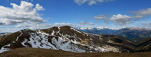
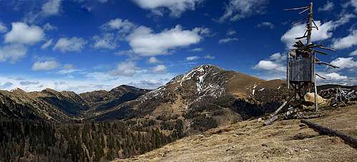
Stileck from Langnock

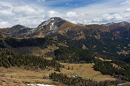
Stileck from Rabenkofel
It's a typical "Nock" mountain, this Stileck. Rounded, with no rock walls, but with alpine pastures almost to its summit. But with great views around and appealing for almost any outdoor activity except rock climbing - hiking, mountain biking and skiing being the most popular. The mountain is situated on the western end of Nockgebirge, close to Rosennock, the highest summit of the group. Southwest of it, the long ridge of Millstaetter Alpe is stretching, with Kamplnock, 2101 m. Rosennock, 2440 m, is to the east, while north of Stileck the Hohe Pressing, 2370 m, is the main summit.
West of Rosennock, there is a strong mountain ridge kind of encircling the highest summit of Nockberge. The very south-western part of this ridge is hosting a group of summits with Stileck, then lowering down to Noeringsattel, 1665 m, which is delimiting our ridge from Milstaetter Alpe. In the very south-western part of our ridge the following summits are worth mentioning: The first one, just north-east of Noeringsattel, is Rabenkofel, 2058 m. It consists of a series of humble ridge elevations. Towards the south-southeast it is sending a distinct side ridge, by which a good approach route also goes. Next to Rabenkofel, less than 1 km to the north-east, rises in the main ridge the nameles Point 2148 m. From it towards the north-northwest a strong side ridge deters to the summit of Stileck, 2179 m. Just before the main summit there is one more bump in the ridge. Stileck ridge is then descending far towards the north-northwest, ending finally at Eisentratten in the valley of Lieser. Getting back on point 2148 m in the main ridge, we can continue towards the north-east and after less than 1 km we'll reach the last summit in our small group, Langnock, 2109 m. That one sends a strong side ridge towards the south-east, while towards the north-east the main ridge descends steeply to the nearby notch 1991 m, on which the Stileck group ends. Grossleobeneck, 2196 m is already a mountain of its own.
In high valley-ends all around Stileck massif there are alpine meadows with many huts, which you may find opened in summer. Also mountain roads are reaching high, but they are closed for public traffic. The most touristically popular area is on the south-eastern side.
Summit Views
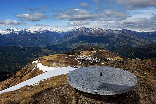
The view on Hohe Tauern
The near neighbourhood of Stileck are rounded Nockberge - on all sides, except on the west, where Hohe Tauern with Hochalmspitze, Grosser Hafner and Reisseck form the most beautiful part of panorama. Nockberge are fine as well, especially the dominant dome of Rosennock, but your eye will soon start searching for the main high summets in the more distant groups. Carnic Alps, Julian Alps and Karawanks are the most beautiful, towards the north you see also some summits of Niedere Tauern.
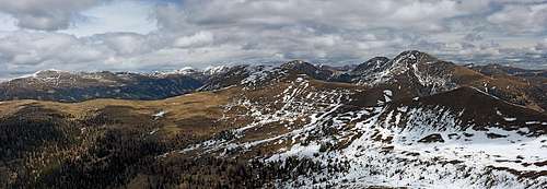 Northern panorama
Getting There
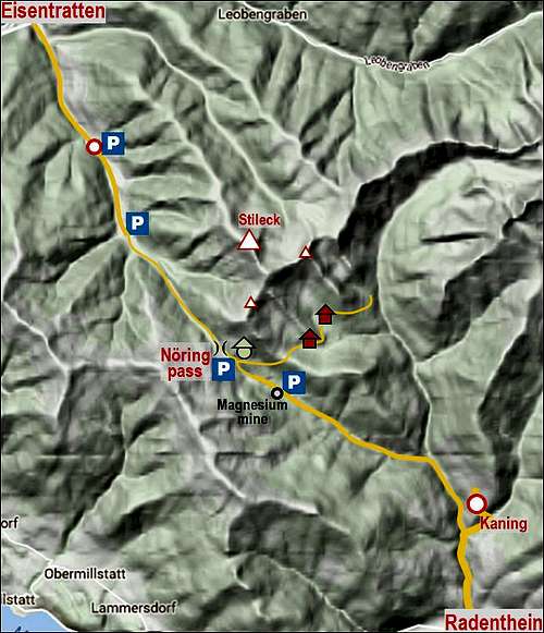
The area of Stileck is quite remote. On a long-distance hike you can reach the summit from any side and from much more distant trailheads, but for one-day tours two approaches are most recommendable:
1. From Kaning by the valley of Globatschbach to Noeringsattel, 1665 m. Kaning is a nice village north of Radenthein, near Lake Millstatt. Driving into the valley, you deter left already below the village (on: 46.818426, 13.704407). A narrow asphalt road leads you by the valley of Kanning Bach, then you deter left into the valley of Globatschbach, following the inscriptions for 'Bergbau' and Lamprechthuette. The last settlement ('Bergbau') in the valley is the place where magnesite is mined. From there, till the pass you will see left of the road mining places, closed for public traffic. The road from mining area to the pass can be closed in some parts of season, but in summer it's usually opened. On Noeringsattel there's a big parking place. Near the pass towards the righ also the road toward Lamprechthuette deters.
2. From Eisentratten by the valley of Noeringbach. You leave the valley of Lieser and drive by the inhabited valley southwards. In winter or spring the tour skiing trailhead can be already at the last farms of Vordernoering, left above the valley, on some 1200 m. In summer, you can drive further - through Innernoering to the trailhead 1160 m, further to the parking place on 1180 m, or all the way up to Noeringsattel, 1665 m.
Routes

I will list just a few hiking possibilities. The popular ski tour follows the summer hiking route by the N-NW ridge, biking options go by mountain roads, including the tour over the Noeringsattel.
1. Stileck Group Round Tour
This one is the best advice. Due to the high trailhead it's still a half day walk up, all the time easy (T2). From Noeringsattel, 1665 m, you go by the road towards the east, towards Lamprechthuette. You can walk by the road till the Thomannbauerhuette, 1697 m, but it is better that already after you pass the Langanderlehuette, you start watching where to deter left and gain the S-SE ridge of Rabenkofel. The forrest is steep there, but passable almost everywhere. When on the ridge, you will see just east below it a broad path, almost cart-road, coming up there from the Thomannbauerhuette. But keep to the ridge till Rabenkofel. Then continue by the main ridge towards the NE, following the trail No. 193. Just before Point 2148 m it crosses the slopes left, gains the ridge of Stileck and in another 10 minutes brings you on its top. From Stileck return back on Point 2148 m and continue by the main ridge towards the NE on Langnock. From there you best descend by its SE side ridge, but only to its flat part on some 1870 m. There you deter sharp right and follow the marked path to Lamprechthuette. Then you only return by the road to the pass. Altogether the elevation to overcome is 680 m, for the whole round tour the average time is 4 h 15 min. (View this route on map, or download its GPX - the two options in header menu.)
 SE ridge of Rabenkofel |
 Rabenkofel ridge |
 Gaining the summit |
 Langnock SE ridge |
Many variants of this tour are possible, especially if starting the ascent at Lamprechthuette. You can for example ascend from Thomannbauerhuette directly on Rabenkofel, you can descend from Langnock also further towards the NE on the notch 1991 m, and return from there via Lamprechtalm, or you can do the round tour in the opposite direction.
2. The North-Northwest Ridge
This is a popular and very nice ski tour (with some 1000 m of altitude difference), but also a nice, quite long walk-up. You can gain the ridge either from Vordernoering (at Hermannhuette, 1600 m), from Hansbauer (at Hansbauerhuette, 1688 m) or using the mountain roads along Gamschitzbach. As on a ski tour, also in summer it's best to keep the ridge as much as possible.
Red Tape
 Rosennock from Langnock ridge |
 Rosennock again |
The whole mountain group lies since 1987 within the Nationalpark Nockberge. Despite its name it is a Protected Area (Category V), so prohibitions of human activities there are not so strict. |
Mountain Huts

Lamprechthuette
- Lamprechthuette, 1660 m. Reachable by mountain road from Noeringsattel. Claims to be the first Austrian wellness farm. Opened in summer season.
- Thomannbauerhuette, 1724 m. Reachable by mountain road from Noeringsattel.
When To Ascend?
Stileck and the surrounding summits can be ascended any time of season. In hard winter conditions the summit ridge can become icy, when a lot of snow (that's rare in Nockberge) steeper slopes can be dangerous for avalanches. Otherwise also the ski tour (N-NW ridge) is an easy one.