
|
|
Mountain/Rock |
|---|---|
|
|
39.80500°N / 105.736°W |
|
|
Hiking, Mountaineering, Scrambling |
|
|
Spring, Summer, Fall, Winter |
|
|
13129 ft / 4002 m |
|
|
Overview
Since this mountain is fairly an easy and short climb, it is ideal for beginners, families, or just anyone who has little time on their hands and wants to climb some alpine peaks. Even though the hikes to the peak are short, the views are spectacular, and the peaks rise well above the timberline. The easy nature of the peaks also belies their danger as severe thunderstorms and lightning strikes are prevalent throughout the summer months.
This and the surrounding peaks are great for winter climbs as well as the trailhead at Berthoud Pass is open year round. With easy access and a high elevation trailhead, this is one of the easiest to climb of the 13 thousand foot peaks in the Rockies.
Of note, the trail up Mount Flora ends on the southern summit, marked 13,132 on the topo map. Most people climbing the peak end here, but the true summit is to the north. On my last climb up Flora on a weekend in July, there were probably 100 people up there, but I was the only one on the true summit!
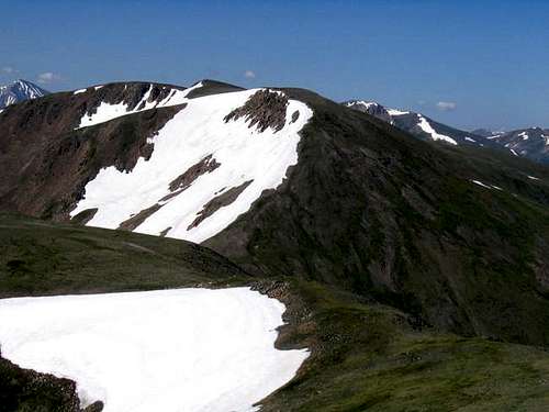 The North Slopes of Mount Flora as seen from near the summit of Mount Eva.
Getting There
The most popular trailhead is at Berthoud Pass, which is on mile marker 243 on Highway 40. Berthoud Pass can be reached from the north and Fraser and Winter Park or from the south and Empire. The Empire exit off I-70 is exit 233 for those driving from the south. Park at the now closed Berthoud Pass Ski Resort parking lot. The trailhead is across the highway. Highway 40 is open and plowed year round allowing easy year-round access to the trailhead.
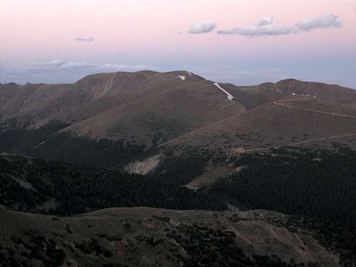 Mount Flora as viewed after sunset from very near the summit of Stanley Mountain on August 18 2009.
Routes Overview
Via Mount Flora Trail
The easiest route up the mountain is the new Mount Flora/Continental Divide Trail. This trail leaves the service road up Colorado Mines Peak at 0.8 miles at the fourth switchback at about 11,700 feet. The trail then curves around Colorado Mines Peak and reaches the saddle north of that peak. From there it more or less follows the ridge to the south summmit of Mount Flora. As mentioned above, the true summit it not that far to the north. The total distance from Berthoud Pass to Mount Flora via this route is 6.4 mile round trip with about 1800 feet elevation gain. The summit of Mount Flora has been updated to 13,129 feet as per LiDAR, but youmay see other elevations published.
Via Coloado Mines Peak
The second easiest route up Mount Flora is to follow the Mount Flora from Colorado Mines Peak route from Colorado Mines Peak. See route page for much more detail. This is a gentle ridge walk, but it is dangerous in thunderstorms. The total distance from Colorado Mines Peak to Mount Flora is 1.9 miles with 350 feet of elevation loss and about 1000 feet of elevation gain. The total distance from Berthoud Pass to Mount Flora is 3.6 miles one way with about 2200 feet total elevation gain and 350 feet elevation loss.
Other Routes
Other possible routes are available. The new Trails Illustated Map; Winter Pass, Central City, Rollins Pass shows a new "trail under construction" over Brekenridge Peak and to Mount Flora. It appears the trail can be approached from several directions including the North Empire Roads from Empire; or from the Mill Creek or Fall River and Rainbow Roads. I am not familiar with these routes, so you will be on your own.
It is also to possible to continue over the ridge north from the summit passing over Mount Eva, Perry Peak, and James Peak. This is a long all day hike for an experienced hiker. Don't attempt it in bad weather.
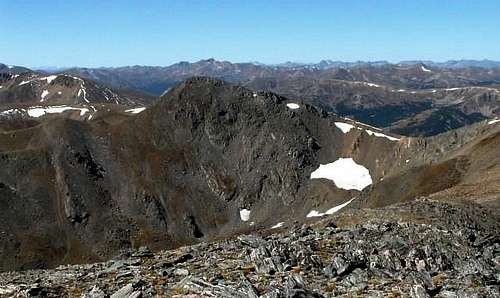 Mount Flora (left) as viewed from Mount Eva. The long ridge between all of these peaks can be followed if the weather is good.
Red Tape
No permits are needed.
When to Climb
This is usually an easy peak all year round, and is a good practice peak for winter. The snow free season is usually late June through early October. Since the routes follow ridge-tops, avalanche danger is usually fairly low as long as you don't stray from the ridge. Highway 40 is plowed in winter allowing for quick and easy access year round.
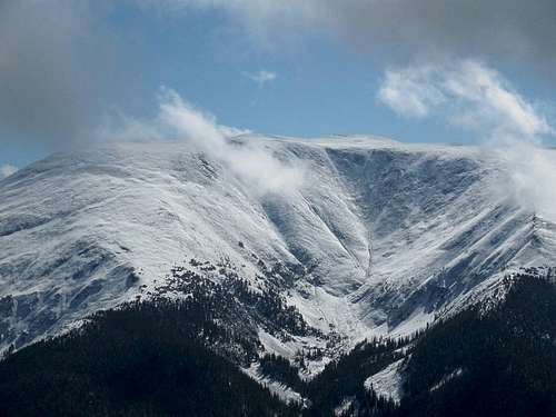 A view of Mount Flora in October.
Camping
These peaks are mostly day climbs only, but there are campgrounds along Highway 40 in the Fraser Valley, and one just south of Berthoud Pass.
There are five campgrounds between Berthoud Pass and Winter Park. These are the campgrounds in order from Berthoud Pass north to Winter Park:
Second Creek Campground
DAR Campground
Spruce Lodge Campground
Midland Campground
Idlewild Campground
For info on these campgrounds listed above, call the ranger station in Granby at 970-887-4100.
There is one campground along Highway 40 just south of Berthoud Pass:
Floral Park Campground
For information on this campground, call the ranger station in Idaho Springs at 303-567-2901.
Mountain Conditions
For current trail and snow conditions, more information, and access issues contact:
Sulphur Ranger District
9 Ten Mile Drive
Granby, CO 80446
970-887-4100
MOUNT FLORA WEATHER FORECAST
Below is the climate summary for nearby Berthoud Pass at 11,315 feet elevation, and at the trailhead. These are all averages, so expect more variation, but this will give you a good idea about the climate at higher elevations in the area. *National Weather Service Data 1950-1985.
| MONTH | HIGH | LOW | SNOW DEPTH | DAYS W/PRECIP |
| JAN | 21 | 1 | 42" | 19 |
| FEB | 24 | 2 | 52" | 16 |
| MAR | 29 | 6 | 63" | 20 |
| APR | 36 | 14 | 67" | 17 |
| MAY | 45 | 23 | 53" | 16 |
| JUN | 54 | 32 | 17" | 11 |
| JUL | 62 | 39 | 0 | 14 |
| AUG | 60 | 38 | 0 | 14 |
| SEP | 53 | 31 | 0 | 11 |
| OCT | 42 | 21 | 3" | 10 |
| NOV | 30 | 10 | 14" | 15 |
| DEC | 23 | 3 | 29" | 18 |