
|
|
Mountain/Rock |
|---|---|
|
|
37.92354°N / 122.59654°W |
|
|
Hiking, Sport Climbing, Toprope, Bouldering, Scrambling |
|
|
Spring, Summer, Fall, Winter |
|
|
2572 ft / 784 m |
|
|
Overview
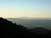
Mount Tamalpais is the most popular outdoors playground in San Francisco Bay Area. It is also the high point of Marin County, California. The mountain is a east-west trending ridge rising dramatically over the surrounding cities and hills, about 10 miles as crow flies north of San Francisco. It has steep slopes on all sides, bounded on the west and south by sea cliffs. From most parts of the mountain there are simply stunning views of the ocean, bay, cities, bridges, rocky outcrops, dense forests, wild flowers, water falls, dramatic ocean cliffs, beaches, pounding surf, fog clouds, sunsets, ...
Mount Tamalpais has three summits, the West, Middle, and East Peaks. The west peak is the highest point, but the east peak is just 4 feet lower and has the best views of the skyline of San Francisco, so it has always been the focal point of tourists. Near the end of 19th century, a cog railroad was built to take tourists to the top of East Peak. Now removed, the railroad path is the "Old Railroad Grade", the easiest and most popular route to the summit from the south. The old railroad station at the summit is now a parking lot for tourists who drive to the top (well, about 300 vertical feet below East Peak). There is a snack bar and visitor center there, as well as picnic facilities. From here it is a very crowded and very short hike to the top of East Peak. The poor summit ambience is compensated by spectacular views in every direction. There are also well-used technical rock climbing routes directly below on huge rock outcrops.
Commonly called "Mount Tam", this is the birthplace of mountain biking. A confusing maze of trails criss-cross the mountain, some designated for bicycles and equistrians and some exclusively for hikers. It is possible to find solitude on the mountain if you hike the north slope and choose the less popular trails. The maze of trails means it is easy to get lost without a good trail map, however, usually you'll be able to find someone to ask within an hour. Being the most popular outdoors playground, there are myriad recreational pursuits here, for example, redwood forest walks (Muir Woods National Monument on southwest slope), beaches and coastal hiking (Muir Beach, Marin Headlands, Stinson Beach), hang gliding (off Bolinas Ridge on the northwest), fishing (several man-made lakes in the north foothills). Mount Tamalpais extends south into Marin Headlands, a series of coastal cliffs even more popular for sight-seeing tourists because of the close-up views of the Golden Gate Bridge and San Francisco.
 |
 |
 |
 |
 |
Getting There
There are many trailheads, the most popular ones are:
| 1. Town of Mill Valley - two trailheads, one on West Blithedale Ave just north of Lee Street (300 feet, the beginning of Old Railroad Grade), or the end of Summit Ave (turn left on Fern Canyon Drive and go to the end, elevation 1000 feet). These are the traditional south side access points. |
| 2. Panoramic Highway - numerous roadside trailheads, these are the most popular access points from the south. To get to Panoramic Highway follow sign from Highway 1. The main trailheads are at Pantoll Ranger Station (1499 feet), the official entrance to Mount Tamalpais State Park, and Mountain Home Inn (900 feet). |
| 3. Muir Woods National Monument - elevation 200 feet. It is possible to do a through-hike from Muir Woods to East Peak, crossing Panoramic Highway at Mountain Home Inn. |
| 4. Town of Stinson Beach - the west side approach from the ocean is a long hike if your goal is the East Peak, however, most people only go as far as Rock Springs / Mountain Theatre (elevation 2000 feet) on the west shoulder of the mountain. Two main trailheads: one is at the Fire House in Stinson Beach, the other is on Highway-1 1 mile south of the first intersection with Panoramic Highway (400 feet). |
| 5. Alpine Lake - a remote trailhead on the northwest side of the mountain (600 feet), at the west end of Alpine Lake on Fairfax-Bolinas Road. Take Fairfax-Bolinas Road from downtown Fairfax and proceed west for a very winding 8 miles. Accesses the Cataract Creek Trail which features waterfalls in spring. You can go as far as Rock Springs, or continue to East Peak. |
| 6. Lagunitas Lake - the more popular north side approach (800 feet elevation) near the town of Fairfax. Take Fairfax-Bolinas road from downtown Fairfax, then follow sign to Lagunitas Park. |
| 7. Phoenix Lake - another north side approach (200 feet), near the town of Ross. Take Lagunitas Road off Sir Francis Drake Blvd in Ross. Go to the end and enter Phoenix Lake Park. |
| 8. Town of Kentfield - this east side approach is at the end of Evergreen Drive in Kentfield (600 feet). |
 |
 |
 |
 |
 |
Public Transportation
The more popular parts of the mountain are well served by public transit (Golden Gate Transit District buses) on weekends and holidays.
Red Tape
Mount Tamalpais is criss-crossed by different jurisdictional boundaries: Mount Tamalpais State Park, Golden Gate National Recreation Area, Muir Woods National Monument, Marin Municipal Water District, Audubon Canyon Ranch, Marin County Parks and Open Space Preserves. If you park at the East Peak parking lot there is a daily fee of $8. The Lagunitas Lake trailhead has a $8 daily parking fee.
When To Climb
Any time of the year. To avoid the crowds, go on a windy winter day, you will get far-ranging views. To appreciate wild flowers and water falls, go in spring. Usually the mountain is never too hot or too cold, it can be somewhat windy near the summits.
 |
 |
Camping
Camping in designated campgrounds, fees and reservation required. The Pantoll Ranger station on Panoramic Highway is the official entrance to Mount Tamalpais State Park, where you can make campground reservations.
External Links
- Mount Tamalpais Hiking Trails
Detailed trail by trail description. - Transit Info
Guide to public transportation on Mount Tamalpais. - Tamalpais Conservation Club
Trail conditions. - climbingbayarea.com
7 technical routes described; 5.4-5.11. - Marin/Napa/Sonoma Co. highpoints, April 30, 2004
Scott Fulton - Jul 2, 2014 2:09 pm - Hasn't voted
Lagunitas Lake day use feeJust to let you know, the day use fee for parking a car at Lagunitas Lake is now $8 (instead of $5). -Scott Fulton
alexgotz - Mar 10, 2017 3:50 pm - Hasn't voted
West Peak is still higherIt is incorrectly stated that the west peak was the highest until leveled. It remains slightly higher than the east peak: West Peak: NAVD88 Elevation: 2579 ft / 786 m (Range 2579 - 2581 ft) East Peak: NAVD88 Elevation: 2575 ft / 785 m (Range 2575 - 2577 ft) Source: http://peakbagger.com/peak.aspx?pid=1159 http://peakbagger.com/peak.aspx?pid=1158
gordonye - Mar 13, 2017 1:20 am - Hasn't voted
Re: West Peak is still higherI've incorporated your correction. Thanks