
|
|
Mountain/Rock |
|---|---|
|
|
45.14750°N / 70.2888°W |
|
|
4150 ft / 1265 m |
|
|
Overview
Bigelow Mountain is located in western Maine along the southern shore of Flagstaff Lake. Bigelow runs in an east-west direction for nearly 12 miles and is comprised of six peaks. Approximately 171 acres of alpine habitat are found on the upper portions of the ridge. The largest alpine communities are found on the central twin cones of Avery Peak (4088') and West Peak (4150'). Further to the west, and only slightly lower, North Horn (3810') and South Horn (3831') rise above the glacial tarn known as Horns Pond. Cranberry Peak (3213') and Little Bigelow (3040') form the eastern and western extents of the ridge. Prominence is 2,845 feet (thanks desainme).
Thanks to RobA for the following info regarding the Bigelow Preserve. Taken from the 2002 A.T. Thru-hikers companion.
"Known as Maine's "Second Mountain", the Bigelow Range might look very different today had it not been for the efforts of many conservation groups, including the MATC. During the 1960s and '70s, land developers had plans to turn the Bigelow Range into the "Aspen of the East", but opponents forced a state referendum on the issue. In 1976, the citizens of Maine decided by a 33,000-vote margin to have the state purchase the land and create a 33,000-acre wilderness preserve. From Stratton to Flagstaff, you will walk through what could have been a series of ski lifts, ski slopes, and summit houses."
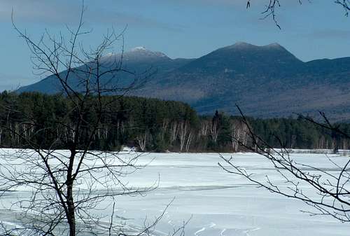 Bigelow as viewed from the northwest across Flagstaff Lake.
ROUTE INFORMATION
Fire Warden's Trail
The Fire Warden's Trail starts at Stratton Brook Pond and immediately crosses Stratton Brook (no bridge). Early on, the grade is fairly moderate passing through a nice section of hardwoods. At 1.6 miles, the Horns Pond Trail leaves to the left (NW). The trail passes Moose Falls Tent Site at approximately 3 miles. It then runs under West Peak and begins the steep climb to Bigelow Col. According to the Maine Mountain Guide (AMC, 8th ed.), the trail gains 1,700 feet of elevation in the next 1.5 miles. The trail ends at the AT (4.6 miles) in Bigelow Col, also the location of Avery Memorial Tent Site. Head east along the AT for 0.4 miles to reach Avery Peak, or head west for 0.3 miles to reach West Peak.
Horns Pond Trail
The Horns Pond Trail leaves from the Fire Warden's Trail 1.6 miles from Stratton Brook Pond. It can be used with the Fire Warden's Trail and the AT to make, in my opinion, one of the nicer loops in the northeast. The trail climbs gradually and passes an old bog with an excellent view of South Horn (probably a good spot to look for moose as well). The grade then steepens as the trail climbs to the ridge and ends at the AT (4.1 miles from Stratton Brook Pond). Horns Pond is located 0.2 miles north along the AT. From the pond, the AT climbs steepily up to South Horn. Just below the summit, a small side trail leads to North Horn (worth the effort). From South Horn, the AT follows the ridge towards West and Avery Peaks.
Appalachian Trail
For northbound hikers from Route 27, the Appalachian Trail climbs steadily to the basin of Cranberry Pond and meets with the Bigelow Range Trail. The AT turns sharply north and climbs steeply through a boulder field and reaches the ridge 1.9 miles west of Horns Pond (4 miles from Route 27). The AT traverses South Horn, West Peak, Avery Peak, and the ridge of Little Bigelow before descending to the southeastern shore of Flagstaff Lake.
Bigelow Range Trail
The Bigleow Range Trail starts at the western end of Bigelow and climbs over Cranberry Peak to Cranberry Pond. The trail climbs moderately to open ledges at 1.9 miles and reaches Cranberry Peak at 3.2 miles. The trail descends to Cranberry Pond and follows the north shore where it ends at the AT, 4.1 miles from the trailhead.
In May 2005, Backpacker Magazine named the Bigelow Range Traverse the tenth most difficult day hike in America in an article titled America's Hardest Dayhikes. Backpacker cited the 17 miles of black flies with attitude and 10,000 feet of elevation gain as reasons for inclusion on the list.
 |
 |
 |
Getting There
From Portland, Maine take I-295N to Augusta. From Augusta take ME-27/16 through Belgrade and Kingfield. The AT crosses ME-27 about 3 miles from the Sugarloaf/USA access road. Stratton Brook Road, a dirt road (usually passable), leaves ME-27 on the right, crosses the AT, and ends at the trailhead for the Fire Warden's Trail. There are small parking areas at both the AT crossing and the Fire Warden's trailhead.
To approach from the northern side of the range, the Safford Brook Trail leaves from East Flagstaff Road, located on the east side of the south shore of Flagstaff Lake. To reach this trailhead, turn north off of ME-16 on Long Falls Dam Road in North New Portland. Turn left onto Bog Brook Road and look for East Flagstaff Road. Go left on East Flagstaff Road and Park at Round Barn Field.
The Bigelow Range Trail leaves from ME-27/16 1/2-mile south of Stratton, Maine (watch for a small sign). If you pass the power plant, you've missed the turn. The trail climbs over Cranberry peak and joins with the AT, making a traverse of the entire ridge possible.
The DeLORMME Maine Atlas and Gazetteer is an essential tool for the Maine hiker.
 |
Red Tape
The entire Bigelow Range is part of the Bigelow Public Reserved Land, a Maine Public Preserved Land that encompasses 36,000 acres. No fees for hiking or camping are required. Many of the access roads are not maintained for winter travel, but can be easily skied or snowshoed. Winter camping is also popular in the preserve.
The Maine Bureau of Public Lands have recently completed a 10 year management plan for the Flagstaff Region, which contains the Bigelow Preserve. It is available for download here.
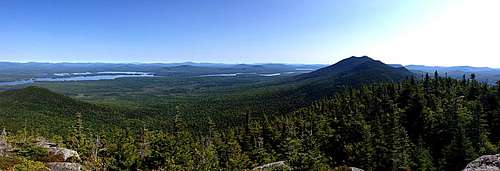 Panoramic view North and East from Cranberry Peak.
When To Climb
Any of the peaks can be climbed year round, but unplowed access roads can make for a long day in the winter. Also, Avery Peak and West Peak rise above treeline and climbers will be completely exposed to the elements. North and South Horn, while bare on top, contain no significant above treeline travel.  |
 |
 |
Camping
There are numerous campsites throughout the preserve. Notable sites include Avery Memorial Tentsite, located in the col between Avery Peak and West Peak, and Safford Notch Tentsite, located just off the AT between Avery Peak and the ridge of Little Bigelow. Moose Falls Tentsite is located adjacent to the Fire Warden's Trail just before the trail begins the steep climb to Bigelow Col. There are a number of places to stay at Horns Pond and near Cranberry peak at Cranberry Pond. Additionally, there are a few primitive campsites near the trailhead for the Fire Wardens trail. The sites are nicely located on or near Stratton Brook Pond.
 |
 |
Mountain Conditions
The highest summits of Bigelow are 3,000 feet higher than the surrounding valleys so plan accordingly. Temperatures are often 10 to 15 degrees cooler and windy conditions are common. Expect to encounter snow/ice starting in November and often persisting well into May. The peaks comprising the range are popular among northeast hikers and the best place for up to date trail conditions is www.viewsfromthetop.com.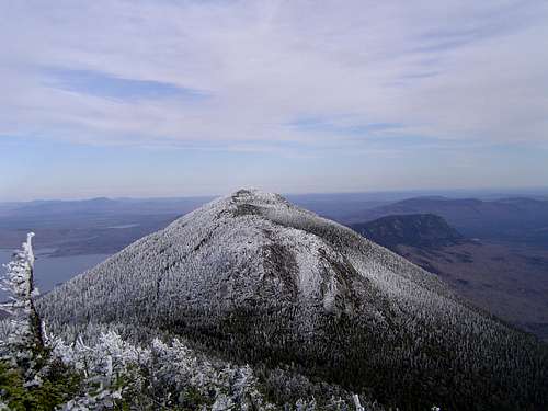 Avery Peak as viewed from West Peak.
desainme - Aug 9, 2005 8:32 pm - Voted 10/10
Untitled CommentProminence is 2855 feet.
Rob A - Sep 24, 2005 8:33 pm - Voted 8/10
Untitled CommentHere is something Interesting taken from the 2002A.T. Thru-hikers Companion
"Known as Maine's "Second Mountain," the Bieglow Range might look very different today had it not been for the efforts of many conservation groups, including the MATC. During the 1960s and '70s, land developers had plans to turn the Bieglow Range into the "Aspen of the East," but opponents forced a state referendum on the issue. In 1976, the citizens of Maine decided by a 33,000-vote margin to have the state purchase the land and create a 33,000-acre wilderness preserve. From Stratton to Flagstaff, you will walk through what could have been a series of ski lifts, ski slopes, and summit houses."
TMF - Jan 18, 2008 12:48 am - Voted 10/10
Avery Peak-West Peakno big deal, but according the the signs on the applachain trail at the col, west peak is actually .3 miles from the col, and Avery is .4.
injektilo - Jan 20, 2008 9:54 am - Hasn't voted
Re: Avery Peak-West PeakThanks for the correction! The page has been updated with the correct mileages.
TMF - Jan 21, 2008 3:59 pm - Voted 10/10
Re: Avery Peak-West Peakno problem...its minor and i wouldnt have even said anything if i had not walked by that sign every day for work when i was on Bigelow...