
-
 11140 Hits
-
 85.87% Score
-
 21 Votes
|
|
Mountain/Rock |
|---|---|
|
|
46.26033°N / 11.68356°E |
|
|
Hiking, Mountaineering, Scrambling |
|
|
Spring, Summer, Fall |
|
|
9035 ft / 2754 m |
|
|
Overview
Cima di Cece 2754 m
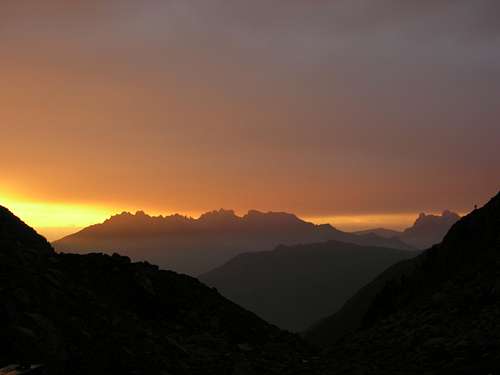
Cima di Cece 2754 m is the highest summit of the long chain of Lagorai, which is a part of the largest group Lagorai-Cima d'Asta, whose highest summit is instead Cima d'Asta 2847 m. This massif is situated to the South of the chain of Lagorai and is geologically different. These two mountain groups, in reason of the low human presence, form the greatest wilderness-area in the Trentino region.
The entire group Lagorai-Cima d'Asta was interested to the military operations of the First World War (WWI), because on this group it was located the border between the Kingdom of Italy and the Austro-Hungarian Empire. Today many hiking paths follow the old war itineraries realized from the two armed forces. Cima Cece was fortified with trenches and roads of castling for the refueling that are largely visible also today.
The Normal route to summit Cima di Cece starts on the side of the Val di Fiemme. It is an highly interesting and varied itinerary, rather long and tiring, but without particular technical difficulties in summer, instead rather challenging in winter. Eventually it is possible to climb in two days by staying overnight at the Bivacco Paolo e Nicola (water at about 200 meters, signposted). The route gains the highest summit of the Lagorai group, in a wild, uncrowded and isolated environment.
ITALIAN VERSION
Cima di Cece 2754 m
Cima di Cece 2754 m è la vetta più alta della lunga catena del Lagorai, che fa parte del più vasto gruppo Lagorai-Cima d'Asta, la cui vetta più alta è invece Cima d'Asta 2847 m. Questo massiccio è situato a sud della catena del Lagorai ed è geologicamente diverso. Questi due gruppi montuosi, a causa della scarsa presenza umana, costituiscono la più grande area selvaggia del Trentino.
L'intero gruppo Lagorai-Cima d'Asta era interessato alle operazioni militari della Prima Guerra Mondiale (Prima Guerra Mondiale), poiché su questo gruppo si trovava il confine tra il Regno d'Italia e l'Impero Austro-Ungarico. Oggi molti sentieri escursionistici seguono gli antichi itinerari di guerra realizzati dalle due forze armate. Cima Cece era fortificata con trincee e strade di arrocco per il rifornimento che sono in gran parte visibili anche oggi. Sul versante della Val di Fiemme parte la Via Normale alla Cima di Cece. Si tratta di un itinerario molto interessante e vario, piuttosto lungo e faticoso, ma senza particolari difficoltà tecniche in estate, invece piuttosto impegnativo in inverno. Eventualmente è possibile salire in due giorni pernottando al Bivacco Paolo e Nicola (acqua a circa 200 metri, segnalata). Il percorso conquista la vetta più alta del gruppo del Lagorai, in un ambiente selvaggio, poco affollato e isolato.
Getting There
The best starting point to summit Cima di Cece is Malga di Valmaggiore.
Road access
•By car using the autoroute A22 (Brennero-Modena): exit Egna-Neumarkt and follow the state road SS48 till Predazzo. In Predazzo take on the right the local road at the beginning signposted with "Ristorante Miola". Pass the restaurant and continue driving on the main road following the signposts "Malga di Valmaggiore". The small road ends in a large clearing at the bottom of which is situated the Malga Valmaggiore. Parking lot on the left about 50 meters before the alm. From the parking lot it begins the path to the Forcella di Valmaggiore and Bivacco Paolo e Nicola.
•By train: Ora-Auer station (railway Monaco-Roma - web site in italian Trenitalia-IT and in english Trenitalia English). From here start the bus services so as described below.
•By bus: using the public services of Società Atesina starting from Trento and/or Ora-Auer or - perhaps better - using the public service of the public company S.A.D.
•Nearest airports: in Verona Aeroporto di Verona; in Venezia Aeroporto Marco Polo; in Bolzano-Bozen Aeroporto di Bolzano.
Il miglior punto di partenza per salire la Cima di Cece è la Malga di Valmaggiore.
Accesso stradale
In auto dall'autostrada A22 (Brennero-Modena): uscita Egna-Neumarkt e seguire la strada statale SS48 fino a Predazzo. A Predazzo prendere a destra la strada locale all'inizio con indicazione "Ristorante Miola". Superare il ristorante e proseguire sulla strada principale seguendo le indicazioni "Malga di Valmaggiore". La stradina termina in un'ampia radura in fondo alla quale è situata la Malga Valmaggiore. Parcheggio sulla sinistra circa 50 metri prima della malga. Dal parcheggio inizia il sentiero per la Forcella di Valmaggiore e il Bivacco Paolo e Nicola.
• In treno: stazione di Ora-Auer (ferrovia Monaco-Roma - sito web in italiano Trenitalia-IT e in inglese Trenitalia English). Da qui partono i servizi di autobus così come di seguito descritto.
• In autobus: utilizzando i servizi pubblici della Società Atesina partendo da Trento e/o Ora-Auer o - forse meglio - utilizzando il servizio pubblico della società pubblica S.A.D.
• Aeroporti più vicini: a Verona Aeroporto di Verona; a Venezia Aeroporto Marco Polo; a Bolzano-Bozen Aeroporto di Bolzano.
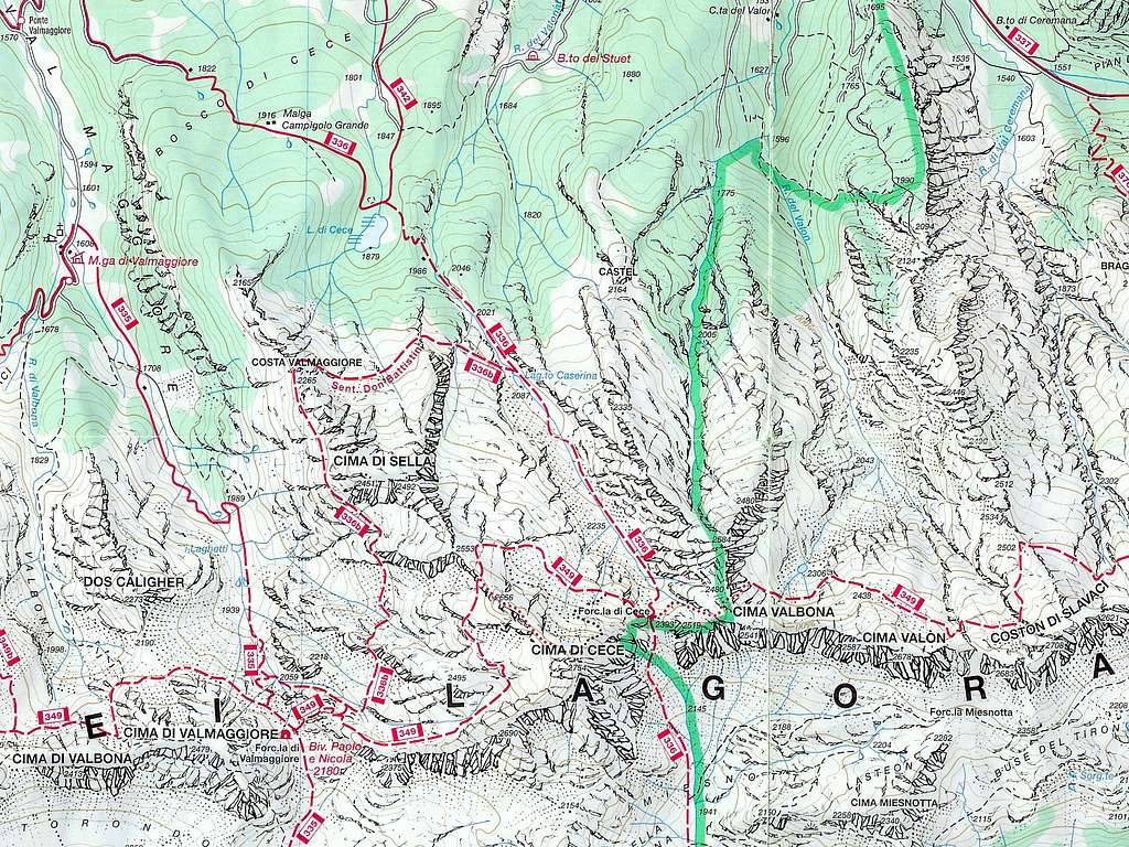
Cima di Cece standard route
Cima di Cece Normal route from Malga Valmaggiore
Difficulty: EE
Difference in level: 1134 m. from Malga Valmaggiore
Exposure: East
Time required: 4 hours to the summit
A route to the highest peak of the Lagorai group in a wild, uncrowded and isolated environment.
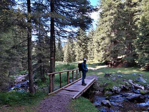
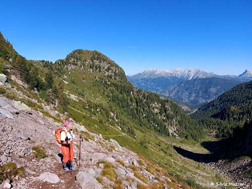
The starting point is the mountain barn named Malga di Valmaggiore (1620 m - restaurant service during the summer). Just before the alm (going up on the left, several signs and an info panel) there is a parking lot where it starts the path SAT n. 335 signposted to the Bivacco Paolo e Nicola. At first you follow a dirt road in the fresh forest, going up the orographic right of the Rio Valmaggiore
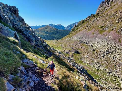
After about twenty minutes you cross a wooden bridge leading to the orographic left bank of the river. Once you reach the plain of the small Lago di Valmaggiore, a glacial lake at 1915 m of altitude, often dry in late summer, the view opens onto the wild detritus valley that we will have to climb up to reach the bivouac. Now we begin to walk on more steep terrain up the Valmaggiore valley keeping to the right near the slopes of the Cima di Valmaggiore. In its upper part the path reaches a fork, here ignore the right path and continue for a few minutes up to the Forcella di Valmaggiore 2180 m, where on the right it is located the Bivacco Paolo e Nicola. Here it's possible also spend the night if the cabin is not busy.
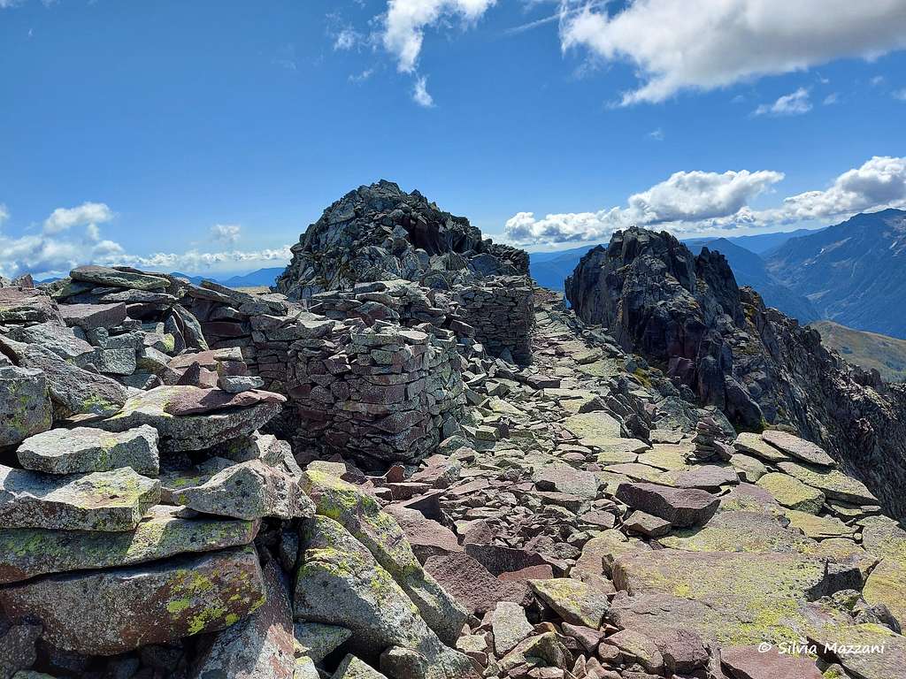
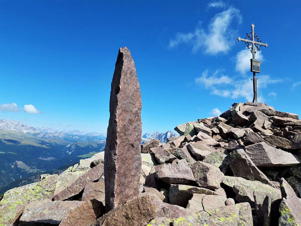
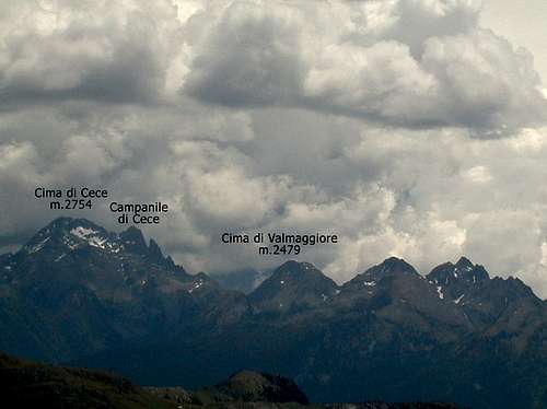
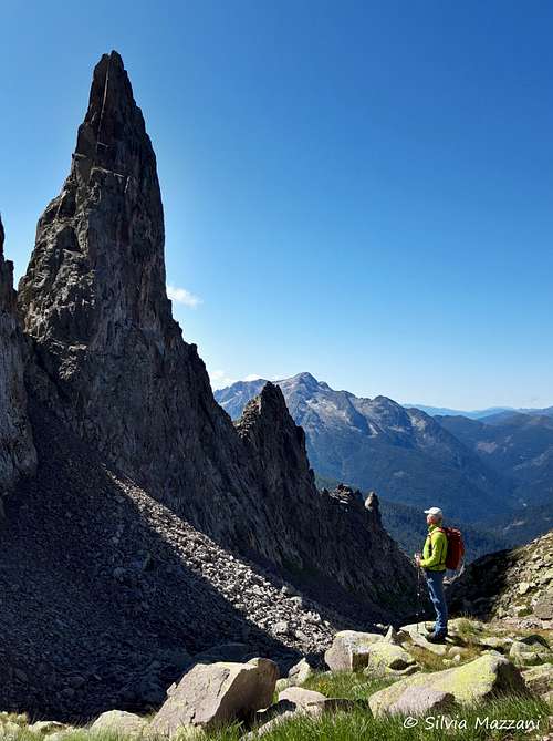
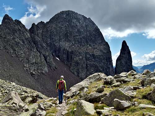
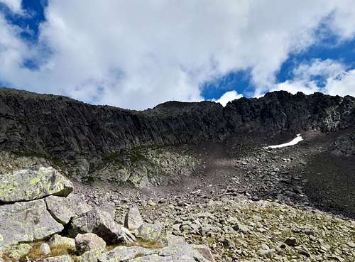
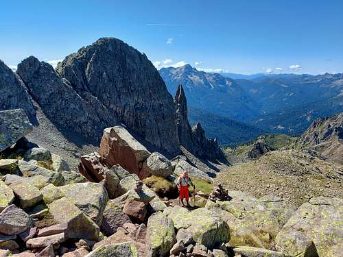
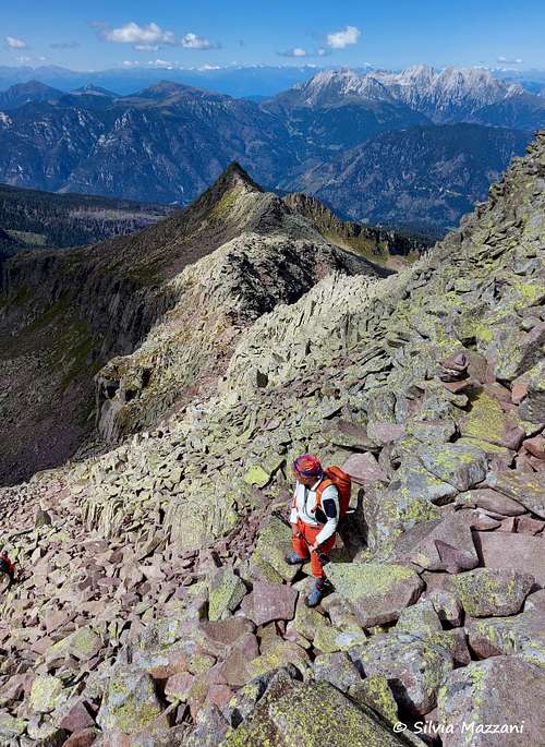
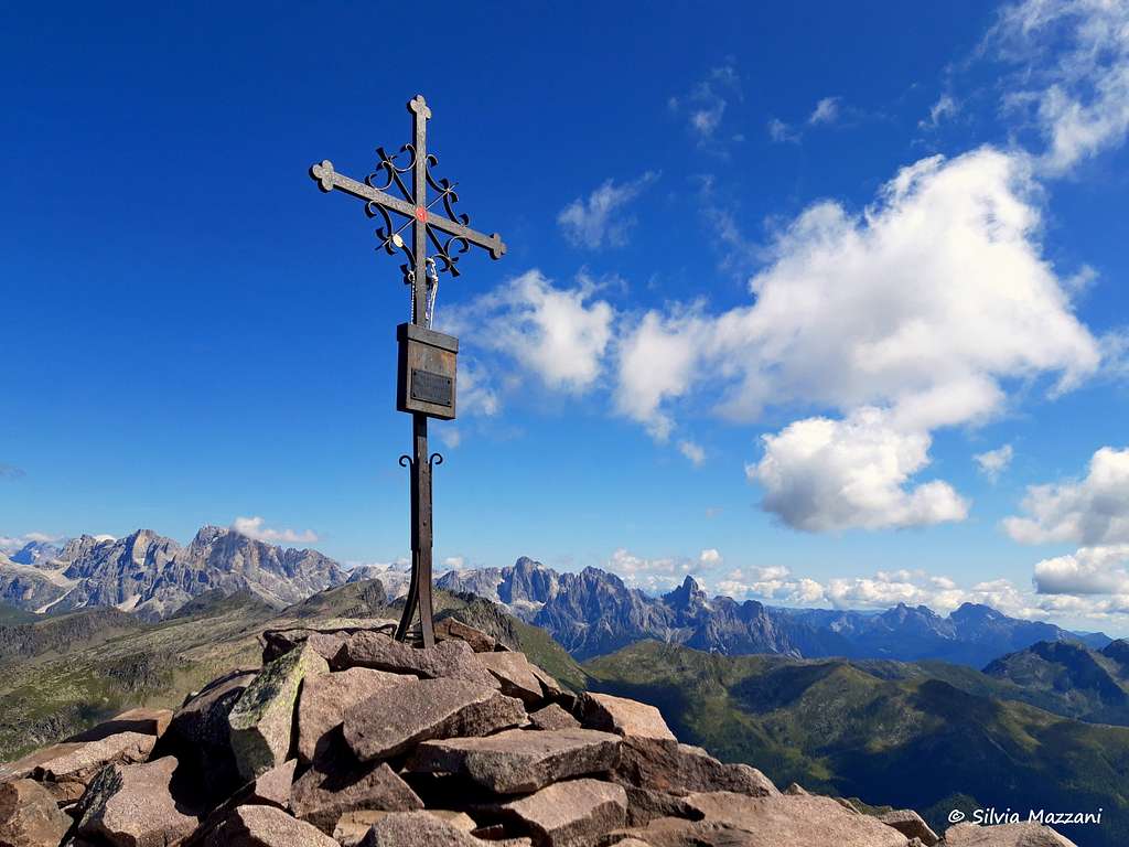
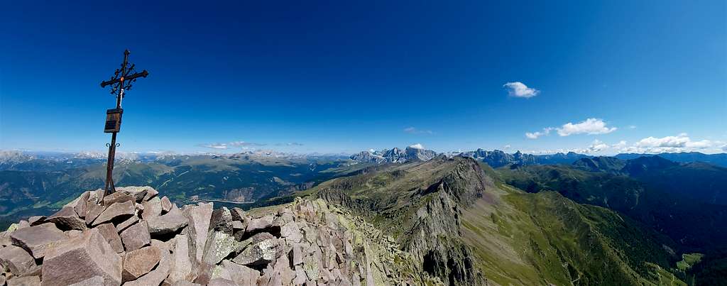
About 50 meters before reaching the bivouac on the left side (orographic right) of the valley, it begins the path SAT 349 in the direction of Cima Cece. Take this war path which with a few hairpins overcomes a bump of grass and steps, reaching the entrance of the Vallone di Cece. The narrow track once again becomes a beautiful war mule track that goes up the wild valley closed on the bottom by our destination, the Cima di Cece, and on the right by the silhouettes of the Campanile di Cece and above all of the magnificent Dente di Cece, both much more spectacular than our goal. Always with a moderate slope and proceeding between large boulders, you reach the head of the valley, where the path leaves the stony ground and begins to climb the slope (remains of dry stone walls supporting the hairpin bends). After a short topsoil gully, you reach a panoramic terrace at an altitude of about 2600 m. From here it branchs the track (signpost) that leads to the top. Always following the military trail, approach the large mass of blocks on the summit until you reach the beautiful and panoramic cross on Cima di Cece (2754 m - summit book). Just below and all around there are extraordinary remains of military posts and notable barracks. The aspect of the summit still today shows the signs of the modifications introduced from the armies: stone walls, several trenches, protections. The panorama is truly vast: the peaks of Lagorài and Cima d'Asta, Catinaccio and Latemar, Marmolada, Pale di San Martino as well as Sassolungo and Sella and, towards the plain, Schiara and Vette Feltrine.
Descent: reversing the same itinerary. Alternatively it is possible to shorten the distance coming down directly to the small lakes Laghetti (m. 1915), avoiding therefore to return to the crossroad that goes to the bivouac. At the crossroad situated a little bit over Forcella di Valmaggiore it is possible to reach directly the alpine lakes Laghetti shorting the way.
• Mountain barn of Valmaggiore > top Cima Cece = m. 1134 (time 3,30 hours)
• Bivouac Paolo e Nicola > top Cima Cece = m. 574 (time 2,00 hours)
Italian version
Il punto di partenza è la Malga di Valmaggiore (1620 m - servizio di ristorazione nel periodo estivo). Poco prima della malga (salendo sulla sinistra, diversi cartelli e un pannello informativo) c'è un parcheggio dove inizia il sentiero SAT n. 335 segnalato per il Bivacco Paolo e Nicola. Si segue dapprima una strada sterrata nel fresco bosco, risalendo la destra orografica del Rio Valmaggiore. Dopo una ventina di minuti si attraversa un ponte in legno che porta alla sponda sinistra orografica del fiume. Raggiunta la piana del piccolo Lago di Valmaggiore, lago glaciale a 1915 m di quota, spesso secco a tarda estate, la vista si apre sulla selvaggia valle detritica che dovremo risalire per raggiungere il bivacco. Iniziamo ora a camminare su terreno più ripido risalendo la Valmaggiore e tenendoci sulla destra, in prossimità delle pendici della Cima di Valmaggiore. Nella sua parte alta il sentiero raggiunge un bivio, qui ignorare il sentiero di destra e proseguire per pochi minuti fino alla Forcella di Valmaggiore 2180 m, dove sulla destra si trova il Bivacco Paolo e Nicola. Qui è possibile anche pernottare se la capanna non è occupata. Circa 50 metri prima di raggiungere il bivacco sul lato sinistro (destro orografico) della valle, inizia il sentiero SAT 349 in direzione di Cima Cece. Si imbocca questo sentiero di guerra che con pochi tornanti supera un dosso erboso e gradini, raggiungendo l'imbocco del Vallone di Cece. La stradina torna ad essere una bella mulattiera di guerra che risale la selvaggia vallata chiusa sul fondo dalla nostra meta, la Cima di Cece, e sulla destra dalle sagome del Campanile di Cece e soprattutto del magnifico Dente di Cece, entrambi molto più spettacolari del nostro obiettivo. Sempre con pendenza moderata e procedendo tra grossi massi, si raggiunge la testata del vallone, dove il sentiero lascia la pietraia e inizia a salire il pendio (resti di muretti a secco a sostegno dei tornanti). Dopo un breve canalino di terriccio si raggiunge un terrazzo panoramico a quota 2600 m circa. Da qui si dirama la traccia (segnavia) che porta in cima. Seguendo sempre il sentiero militare, ci si avvicina al grosso masso sommitale fino a raggiungere la bella e panoramica croce sulla Cima di Cece (2754 m - libro di vetta). Poco sotto e tutt'intorno vi sono straordinari resti di postazioni militari e notevoli caserme. L'aspetto della vetta ancora oggi mostra i segni delle modifiche introdotte dagli eserciti: muri in pietra, numerose trincee, protezioni. Il panorama è davvero vasto: le vette del Lagorài e della Cima d'Asta, del Catinaccio e del Latemar, della Marmolada, delle Pale di San Martino oltre al Sassolungo e del Sella e, verso la pianura, la Schiara e le Vette Feltrine.
Discesa: seguire lo stesso itinerario di salita. In alternativa è possibile accorciare il percorso scendendo direttamente ai Laghetti (m. 1915), evitando quindi di ritornare al bivio che va al bivacco. Al bivio situato poco sopra Forcella di Valmaggiore è possibile raggiungere direttamente i laghetti alpini Laghetti in breve.
• Malga di Valmaggiore > vetta Cima Cece = m. 1134 (time 3,30 hours)
• Bivacco Paolo e Nicola > vetta Cima Cece = m. 574 (time 2,00 hours)
Red Tape
No fees no permits required
Huts and bivouacs
- Along the way, on the Forcella Valmaggiore, there is the Bivacco Paolo e Nicola 2180 m. It consists of a cozy wooden cabin and was built in the year 1974 from the Juvenile Tourist Center of Predazzo. Equipped with 6 beds, kitchen and pottery. Always open, with water to 200 meters on the source to the South of the Forcella di Valmaggiore and normally supplied of firewood.
- At the start you will find the Malga Valmaggiore 1620 m (restaurant service during the summer).
- Lungo il percorso, sulla Forcella Valmaggiore, si trova il Bivacco Paolo e Nicola 2180 m. Si compone di un'accogliente baita in legno ed è stata realizzata nel 1974 dal Centro Turistico Minorile di Predazzo. Dotato di 6 posti letto, cucina e stoviglie. Sempre aperta, con acqua a 200 metri sulla sorgente a Sud della Forcella di Valmaggiore e normalmente fornita di legna.
- Alla partenza troverete la Malga Valmaggiore 1620 m (servizio di ristorazione nel periodo estivo).
Summit panorama
The summit offers a wide panorama opened to north on the Val di Fiemme and many dolomites's groups like Latemar, Catinaccio, Sassolungo, Sella, Marmolada and others more distant, to east towards the Pale di San Martino, to south towards the Cima d'Asta and the Prealpi Venete, to west in direction of the Gruppo di Brenta, far away but very visible.
 West |
 North |
 East |
 South |
La vetta offre un ampio panorama aperto a nord sulla Val di Fiemme e molti gruppi dolomitici come Latemar, Catinaccio, Sassolungo, Sella, Marmolada e altri più lontani, ad est verso le Pale di San Martino, a sud verso la Cima d'Asta e le Prealpi Venete, ad ovest in direzione del Gruppo di Brenta, lontani ma ben visibili.
Accomodation
Different possibilities in Predazzo.
When to climb
Climbing and hiking: the best period is during summer or early fall.
Sky-mountaineering: from February to mid May
Meteo
Guidebooks and maps


"Lagorai Cima d'Asta" by Mario Corradini - Collana Guide Monti d'Italia, Milano 2006 - a complete and exaustive guide to hiking and climbing into the most large wilderness-area of Trentino. Edited by the Touring Club Italiano in collaboration with the Club Alpino Italiano
"Lagorai Cima d'Asta - Climbing on the granite of the Dolomites" by Alessio Comz, Gianfranco Tomio, Edizioni Versante Sud
Maps
- Carta Tabacco 014 - Val di Fiemme-Lagorai-Latemar 1:25000
- Carta Tabacco 058 - Valsugana Tesino
- Carta Kompass 626 (Catena dei Lagorai-Cima d'Asta) 1:25,000 or Kompass 621 (Valsugana-Tesino) 1:25,000
•Books: for news wide and deepened on the course of the forehead and the military operations in the zone, it is indispensable to refer to the historical work of Walther Schaumann: "La grande guerra 1915-18, Volume 3 - Prealpi Venete e Trentine", Ghedina & Tassotti Publisher Limited, Bassano del Grappa (Italia), 1984 (this is the italian version of the original “Schauplaetze des Gebirgskrieges - Oestliche Dolomiten, Sexten, Cortina di Ampezzo”. Colonel Walther Schaumann also has founded the association Friends of the Dolomites that has cured the arrangement of trenches and distances of war.
External links
•History: numerous historical references to the war operations of the first world war are available into the multimedia encyclopedia Wikipedia. We have chosen this only external link one because the reperibile material in the WEB is truly too much wide. The various national versions of Wikipedia concur to form a frame of the facts to my opinion enough objective. See the italian, english and german version.
•Tourist office:
•Azienda per il turismo Lagorai
•Azienda per il turismo Val di Fiemme
•Local alpine club: Società degli Alpinisti Tridentini S.A.T.
•Local meteo: MeteoTrentino