
-
 13472 Hits
-
 83.43% Score
-
 17 Votes
|
|
Mountain/Rock |
|---|---|
|
|
43.95030°N / 103.7694°W |
|
|
Pennington |
|
|
Hiking |
|
|
7164 ft / 2184 m |
|
|
Overview
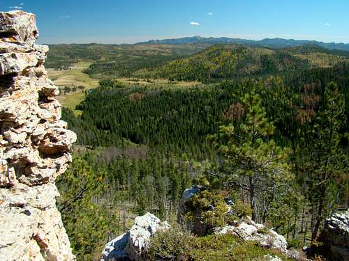 Summit View Southeast
One of the highest summits in the Black Hills is often overlooked, due to its remoteness and lack of prominence. However, this mountain is really a "hidden gem" and the hike to the summit is quite enjoyable. The summit is most often visited by snowmobilers for the summit view listed on their maps as “Clinton Overlook”. ATV riders sometimes visit the summit in the summer, but hikers rarely visit this high and lonely mountain. Hopefully, in time, more will get to enjoy the great views along the trail and from the summit. Nearby Odakota Mountain, the second-ranked summit in the Black Hills, sits just two miles to the south, with a shallow saddle that keeps Green Mountain from being the fourth-ranked summit. Lists of John places Green Mountain with 214 feet of prominence. However, the mountain rises nearly 1,000 feet from Slate Creek to the east, giving a splendid view of the region. There are several of the other Black Hills highest summits close by, including Odakota, Bear Mountain, Medicine Mountain, Hat Mountain, and Copper Mountain. Summit views not only include the nearby summits, but also Harney Peak to the southeast, Custer Peak to the northeast, Terry Peak to the north plus some views of Deerfield Lake, also to the north. The summit area of Green Mountain is gently sloped and lightly forested with aspens, pines and a few spruce trees. Mule deer are in abundance there, and my 2015 visit showed no mountain lion tracks on the summit trail or anywhere else I explored. Because of some dead trees scattered through the forest, there seemed to be an abundance of woodpeckers there as well. The only other people I saw on the mountain were in one small group of ATV riders in a caravan on Forest Road 301.1R. Other than this brief encounter, I pretty much had the whole mountain to myself on a beautiful early fall day. There is no geodetic marker at the summit, and unless you bring a good GPS, you will probably not know for sure if you have found the exact true highpoint. There is a summit cairn there, but I do not know if it is accurate.
Getting There
Because of the large array of forest service roads in the area, there are many optional ways to travel to Green Mountain. However, the most common way seems to be from Hill City. Perhaps the quickest way that traverses the shortest distances on gravel roads, would be to travel 8.7 miles west from Highway 385 on the Deerfield Road (paved) to East Slate Creek Road (Road 300, and unpaved). On Slate Creek Road, travel southwest 4.2 miles to the junction with Medicine Mountain Road. On Medicine Mountain Road, travel south and go 1.2 miles to Six Mile Road, then turn west and travel 3.6 miles to Forest Service Road 301.1R (which is also Snowmobile Trail 2 South). Hike or drive north 1.3 miles to the junction with Snowmobile Trail 2B East. The snowmobile trails all have orange markers (often, but not always diamonds). There will be a gate .3 mile north of Six Mile Road. That gate must be shut after you pass through. If you drive to the junction with Snowmobile Trail 2B East, you will have to find an off-road place to park that allows other traffic to pass by safely.
Route Options
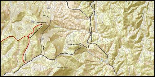 Green Mountain Route Options
 FSR301.1R Marker
 FSR301.1R junction with Trail 2B East
For an easy trip to the summit, you can hike .9 mile to the summit from the junction of Forest Service Road 301.1R and Snowmobile Trail 2B East. If you prefer a longer trek, you can park near the junction of Six Mile Road and Forest Road 301.1R and hike to the junction with Snowmobile Trail 2B East and on to the summit for a 2.2 mile (one-way) route. The map above will show you your options. The map above also will show you Forest Road 656 that winds around the steep eastern face, some 400 feet below the summit. If your preference is bushwhacking up steeper and more challenging terrain, then this is your best option for Green Mountain. Given the amount of downed timber on the eastern slopes, climbers there will find the going somewhat tougher than on slopes undamaged by pine beetle kill.
Red Tape
Unless the surrounding area has to be closed for a forest fire or weather emergency, Green Mountain is accessible year-around. The Black Hills National Forest office in Custer manages the area, and can be reached at: (605) 673-9200. You can access their website at:
Black Hills National Forest Headquarters.
If you camp on the mountain, please do not forget that campfires are illegal.
When to Climb
 Summit Cairn
Green Mountain can be accessed year-around. But please be advised that because of the altitude, summer lightning and hail can be deadly, and winter brings deep snowfall and sub-zero temperatures to this area of the Black Hills. If you choose a winter hike, it may be to your advantage to wait until the snowmobiles have made a few runs over the route to the Clinton Overlook. Hunting seasons also bring some risks, so if you must hike then, please make yourself visible by wearing plenty of bright orange. You can check for South Dakota hunting season information at this link:
For the latest weather forecast and report on current conditions in the Green Mountain area, click on this link:
Green Mountain – Deerfield Area Weather Information
Maps
Some good maps for the Green Mountain area would include the Black Hills National Forest map, sold at most forest service offices. The forest service also has a free Motor Vehicle Use map that will help with back roads accessible to the public. The map for the Green Mountain area is the Mystic and Hell Canyon Ranger Districts. You can also access a downloadable PDF map for the Black Hills snowmobile trail system by clicking here:
Black Hills Snowmobile Trail System Map
Camping & Lodging
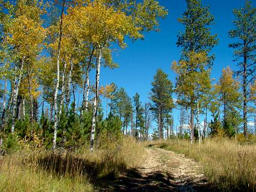 Fall colors in the summit area
Most of the camping and lodging in the Green Mountain area will be found east, in the Hill City area and north, around Deerfield Lake. The visitors sites listed below should give you up-to-date information for campgrounds and lodging nearby.
Hill City Area Visitors Center
Black Hills National Forest Campgrounds
Mountain Meadow Resort at Deerfield Lake
The Black Hills National Forest also allows back-country camping, however campfires are prohibited. You can access their camping regulations at this link:
Black Hills National Forest Back Country Camping Regulations & Information