
-
 2741 Hits
-
 77.48% Score
-
 8 Votes
|
|
Mountain/Rock |
|---|---|
|
|
45.00087°N / 110.08235°W |
|
|
Mountaineering, Scrambling |
|
|
Summer |
|
|
10270 ft / 3130 m |
|
|
Overview
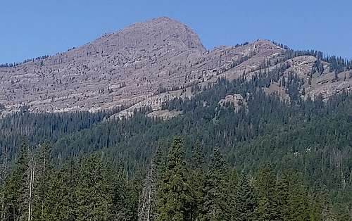
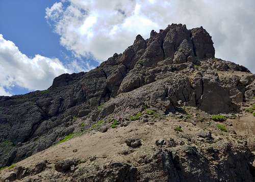
In Yellowstone, from about the Pebble Creek Campground almost to the Northeast Entrance, there is a long ridge system just west of the road that features three distinct summits.
Of those, the southernmost, Barronette Peak, is the highest at 10,442'. To its north is the next peak, which is close to 10,200' and has enough prominence to count as a ranked peak. Finally, north of that peak is North Barronette Peak at 10.270'. (Between the central and northern peaks is Point 9925T, which does not have enough prominence to be ranked).
North Barronette Peak is not an official name; on maps, it has the undignified name "10,270T." However, given that it is about three miles from Barronette and that one would likely use completely different approaches for both, it definitely is an entity of its own and deserves that recognition.
Although you will encounter Class 4 climbing and may encounter Class 5 climbing, you should leave the gear behind because the rock is mostly untrustworthy. To put it differently, if you think falling on up to 5.4 rock is a possibility for you, stay away from this peak because any protection you place is unlikely to work here; it's the rock that will fail, not the gear. That said, I did find a rap station seemingly made to allow ski mountaineers to access a steep, long couloir, but in a way that underscores the point; you may be able to trust slung boulders, but you should not trust cracks, constrictions, etc. as the breccia here is "portable."
Getting There
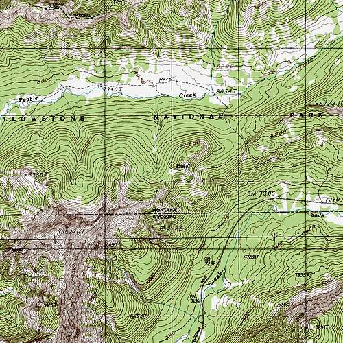
1.2 mi from the northeast entrance, park at the Warm Springs parking area, which is on the north side of the road. This is the eastern end of the Pebble Creek Trail.
Route
From Warm Springs, the trail gains over 1000' in about 1.5 mi, sometimes yielding superb views of Amphitheater Mountain and Abiathar Peak across the drainage of Soda Butte Creek.
At this point, the trail reaches a pass, but the pass is broad and forested, which makes the next part of the approach tricky.
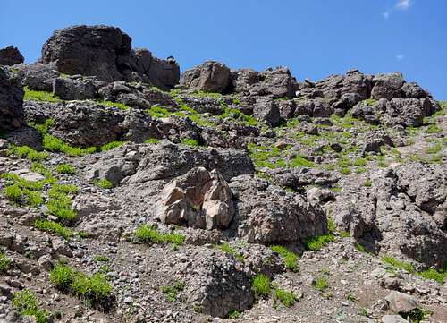
Once you realize you are at the pass, you have to turn left (southwest) and go virtually blind through forest and deadfall, trying not to lose elevation, until you reach the first real sign that you're heading the right way: a short limestone band.
Climb through it or look for a work-around; I found a low-5th way through. On USGS maps, that limestone band is the clear spot at about 8600'.
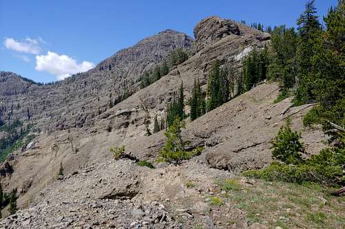
Don't get happy yet; the clean route you might have eyed from the road is not that at all. Keep following the path of least resistance uphill. Soon, the exposed rock will be breccia, and you'll think you're on that beautiful-but-challenging-
After you reach a mini-summit, you have to confront the dismaying fact that you'll have to descend about 200' into a basin just to thrash your way through trees and debris in order to attain that ridge.
And that's when the fun begins. Quickly, the ridge deteriorates into a series of pinnacles with notches between them, and some of those notches are deep and steep and not things you want to climb either up or down.
After dealing with a few of them, I descended a couloir on the west side of the ridge and then contoured across until I could go up relatively easy terrain again and attain the ridge past the pinnacles.
Soon comes what may be the mental crux: a knife-edge section with exposure that will deter many sane, reasonable people.
Once you are past that, just follow your nose. There are probably multiple ways to the summit, and mine was too meandering and complicated to try to describe. But no matter how things look, it does go; if one way shuts you down, look for another.
To my suprise, considering the effort involved, there was a summit cairn, though, in keeping with what seems to be Wyoming norms on all but the most popular peaks, there was no register.
I did not track the route, but I would put it at 4-5 miles, with most of it off-trail. Elevation gain from car to summit is about 3000', but the ups and downs turn this into something more like a 4000' day in all.
|
|
|
Red Tape
As of 2019, it's $35 for park entry, but that does cover you for a week.
You'll be traveling in grizzly country, so know what to do; this page will not cover that.
When to Climb
Late spring through early fall.
Camping
The closest campground in the park is Pebble Creek; there are no reservations, and in summer you had better arrive before 9 A.M. if you want to get a site. Slough Creek CG is several miles east and also does not take reservations. You can sleep in your car at the pullout just outside the NE entrance since that is National Forest land.