
-
 5373 Hits
-
 78.27% Score
-
 9 Votes
|
|
Mountain/Rock |
|---|---|
|
|
45.04572°N / 109.9997°W |
|
|
Mountaineering, Scrambling |
|
|
Summer, Fall |
|
|
10204 ft / 3110 m |
|
|
Overview
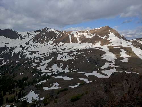
Remote, obscure, and seldom climbed, Sunset Peak is in the Montana portion of the Northern Absaroka Range and sits on the boundary of Yellowstone National Park and the Absaroka-Beartooth Wilderness.
For those who care about these things, Sunset is not a ranked peak. Technically speaking, it is probably a subpeak of the higher unnamed peak just to its south. Why it has a name when its higher parent does not is something I do not know. Nor do I much care.
Although it's not a particularly remarkable peak in form or difficulty, Sunset Peak has beautiful views of the surrounding mountainous country. Although it can be a fine destination on its own, you're probably more likely to climb it if your objective is Wolverine Peak to the north or Mineral Mountain to the south.
Getting There
It's possible to approach Sunset Peak from inside Yellowstone, but it would involve about 4-5 miles of trail hiking over a pass and down into Pebble Creek, and then off-trail travel of about the same distance to reach the summit.
A much easier approach is from Cooke City.
Just east of Cooke City, turn onto the dirt road for Daisy Pass. You can drive to either Daisy Pass or Bull of the Woods Pass (both are about 5 miles from the pavement), and you will need high clearance for either. The road to Bull of the Woods Pass is rough and steep in places and will require 4wd; although the approach from Daisy Pass is a little longer, you should not need 4wd unless conditions are wet or snowy. There is also a road connecting Daisy and Bull of the Woods. When clear of snow, it, too, is an easier alternative to the road up to Bull of the Woods.
Route
From Bull of the Woods Pass, one-way distance is 2.5-3 miles with around 1500' of elevation gain. That doesn't sound too bad, but because it involves two or three summits and the ups and downs entailed, the day is going to be longer and harder than it sounds.
You will have to first climb Miller Mountain, and, unless the snow is melted out, its false summit.
From the pass, follow the ridgeline, surmounting or bypassing obstacles as necessary. It is not necessary to climb the false summit directly south of the pass if the snow is gone or if you have the equipment and experience for traversing steep snow slopes.
There will be some Class 3 terrain, but you should be able to avoid anything harder than that. However, beware crumbly rock. It's the norm in these mountains.
|

|
From the summit of Miller, descend west to a basin beneath Sunset Peak. Follow goat trails whenever you can. Expect some scrambling, but nothing too bad. It is, however, less direct and more challenging than it looks on a map or from Miller's summit.
Now ascend slopes to the Sunset summit. When I climbed it, it was early July and there was a snowfield going almost all the way up, so I took that over loose Class 2-3 terrain.

|

|

|
Red Tape
There are some private mining claims about; try to avoid them.
This is grizzly country.
When to Climb
Summer and early fall are best. Because of heavy ATV and snowmobile usage around Cooke City, the passes may be accessible in winter.
Camping
Plenty of dispersed camping.