
-
 7812 Hits
-
 84.27% Score
-
 18 Votes
|
|
Mountain/Rock |
|---|---|
|
|
36.56430°N / 74.41196°E |
|
|
Mountaineering |
|
|
Summer |
|
|
20718 ft / 6315 m |
|
|
Overview
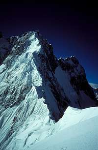
The Northwest Ridge of Beka Brakai Chhok
Point 6315m is located between Sani Pakush (6952m) and Beka Brakai Chhok (6882m) on the Batura Wall. The Batura Wall is a high ridge in the Batura Muztagh, the westernmost sub-range of the Karakoram. There are a number of 7000m peaks including Batura I (7794m) on this remarkable ridge which extends over 35km without dropping below 6100m. The 56km long Batura Glacier is the fourth longest in the Karakoram and lies below the northern slopes of the Batura Wall.
Point 6315m was first climbed by Pete Thompson solo in July 1998 during an attempt on the then unclimbed Beka Brakai Chhok. Thompson climbed the northeast spur of Point 6315 from the Batura Glacier before climbing a short way up the northwest ridge of Beka Brakai Chhok central peak. The convoluted knife-edge ridge proved too difficult for a solo climb. Beka Brakai Chhok central peak remains unclimbed although Beka Brakai Chhok South was climbed on 1st August 2008 by Simone Moro and Herve Barmasse from the Baltar Glacier.
Apart from an ascent of Seiri Porkush at the far western end of the Batura Glacier, the line on Point 6315m appears to be the only other route to the crest of the Batura Wall from the Batura Glacier. Five climbers died during an early attempt on Batura I from this side and the great ice flows descending from the wall to the glacier are not conducive to climbing.
Getting There

The Batura Glacier from Yunz Valley.
The nearest international airport is Islamabad. PIA flies daily from Islamabad to Gilgit, the biggest town in the Northern Areas. The flights are sometimes cancelled at short notice due to bad weather.
Gilgit can also be reached by bus along the Karakoram Highway from Pir Wadhai bus station in Rawalpindi. Buses leave in the afternoon and arrive around mid morning the next day, but can be delayed if the road is washed out or blocked by landslides. See www.lonelyplanet.com/thorntree for a travel forum and the latest on travel on the Karakoram Highway.
From Gilgit, continue on the Karakoram Highway up the Hunza Valley past Attabad Lake to Passu.
Trekking to Base Camp
Porters can be hired in Passu. From Passu a popular trek follows ablation valleys along the northern edge of the Batura Blacier. Pass the summer settlement of Yashpirt and reach the yak grazing pastures at Lupdhor after 3-4 days, with great views of the Batura Wall along the way. My base camp was at Lupdhor, although the mountain is still 10km away. A better site would be at China Camp, which is close to the mountain on the north side of the glacier.
Red Tape
A visa is required and must be obtained prior to arrival. A single entry tourist visa is valid for three months from arrival. It is possible to extend visas in Islamabad.Currently (2010), peaks below 6500m in Pakistan do not require a permit. Nor is a liaison officer required. An agent can be employed to provide staff and other services.
Good agents I have used are:
1.Adventure Tours Pakistan
2.Himalaya Trek and Tours
Camping
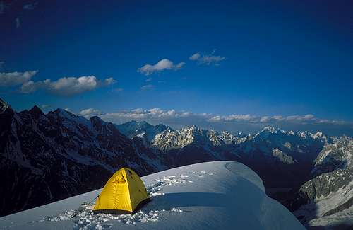
Camp at 5050m on the Northeast Spur of Point 6315m
Campsites
There are nice campsites on the ablation valleys along the Batura Valley, particularly at Lupdhor.
Camping Fuel
Kerosene is available in Gilgit and other towns but it burns very sooty so be prepared to clean your stove. White gas is not available. Gas canisters left by previous expeditions are available in Gilgit. Canisters are said to be refilled, but they have always worked for me. Otherwise canisters will need to be freighted from abroad or bought from your agent.
Expedition Food
A good selection of food is available in Islamabad, Gilgit or Karimabad. A very limited selection of food is available in Passu. The only food you might consider bringing with you is special mountain food.
Accomodation
This is cheap in Pakistan. In Gilgit the New Madina Guesthouse is recommended. There are a few guesthouses in Passu.
The Route

Point 6315m Route
The northeast spur of Point 6315m starts abruptly from the flat Batura Glacier at 4200m. Climb snow and ice slopes to the summit. One section is threatened by seracs. Ocassionally steep, alpine AD.
The northwest ridge of Beka Brakai Chhok is a difficult, convoluted knife-edge ridge.
Climbing Conditions
Some deep snow was encountered on the northeast spur. The start of the northwest ridge of Beka Brakai Chhok was sugary snow on top of hard ice.
When to Climb
The climbing season is from June to mid September. The monsoon from the Bay of Bengal moves westward and reaches Pakistan in late June through to September. The Karakoram is in the Himalayan rain shadow which limits the effect of the monsoon. However when the monsoon breaks down country it’s usually stormy in the mountains. The weather can change very quickly with snow fall higher up or heavy rain at lower altitudes. Climbing in the Karakoram requires considerable patience. There can be extended spells of good weather; the difficult thing is predicting when they will be.
Research
MapsBatura Mustagh Orographical Sketch Map 1:100,000 by Jerzy Wala.
An excellent and accurate map which also includes topo-diagrams of some routes on the higher peaks.
Swiss Foundation for Alpine Research Karakoram 1:250,000 Orographical Sketch Map. Sheet 1 shows Batura.
Popular and useful maps which are generally accurate.
Books
Chronik der Erschließung des Karakorum by Wolfgang Heichel. Teil I – Western Karakorum. Wissenschaftliche Alpenvereinshefte, Heft 36. Gemeinsam herausgeben vom Deutschen und vom Österreichischen Alpenverein. München 2003.
This is the first volume of what is intended to be an exhaustive chronicle of the climbing history of the Karakoram range. It contains stacks of useful information and excellent maps by Jerzy Wala. Volume I covers the mountains west of the Hunza River including the Batura Muztagh. Volume II is intended to cover the Rakaposhi Range and Volume III the Hispar Range. Only available in German.
Karakoram: Mountains of Pakistan by Shiro Shirahata (1998) ISBN: 093856725X
Stunning photos including Batura.
Websites
www.climbmagazine.com for Mountain Info, a record of world mountaineering.
www.americanalpineclub.org for online American Alpine Journal expedition reports.
www.alpineclub.org.uk for the Himalayan Index, a useful starting point to determine what has been climbed on peaks 6000m and above.
http://blankonthemap.free.fr/default.htm is a website in French and English devoted to the mountains of Northern Kashmir i.e. the Karakoram, Nanga Parbat, Hindu Kush and Hindu Raj.