
|
|
Mountain/Rock |
|---|---|
|
|
36.36859°N / 75.27499°E |
|
|
Gojal |
|
|
Mountaineering |
|
|
Summer |
|
|
20679 ft / 6303 m |
|
|
In Memory of Ben Cheek
This page is dedicated to my friend Ben Cheek who tragically died during an attempted climb of the North-East (aka North) Face of Shimshal Whitehorn in July 2008.Overview
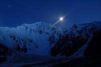
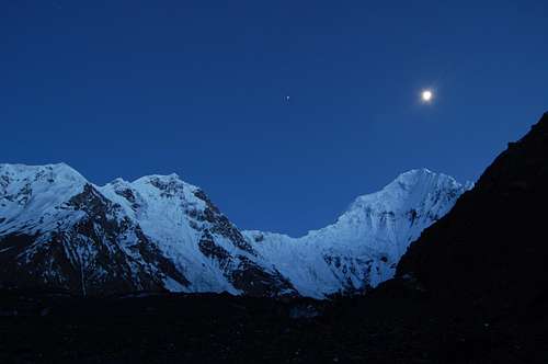
Shimshal Whitehorn at night from our bivi sight at 4600m
Shimshal Whitehorn is one of Shimshal’s most famous mountains and in my opinion one of the most beautiful in the whole Karakoram. The left side of its north-east face consists almost solely of seracs while its right side is smooth and sheer. The peak is also known as Adver Sar, Ishpardin and Shimshal Weisshorn. Having attempted, and failed, to climb this mountain three times I also have a number of names of my own for this peak that I cannot print here!
The mountain is located a day’s trek from the village of Shimshal, however, with a base camp approximately 1400m above Shimshal the approach is not the easiest. Other approaches are also possible via the Yazghil and Malangutti glaciers however the mountain is difficult to climb from all directions. Whichever way the mountain is climbed though it is a serious undertaking, both technically and physically.
The mountain's climbing history was unclear to many until recently due to it mostly consisting of a number of illegal attempts that resulted in a number of unfortunate deaths. Many people, including local climbers believed the peak to still be unclimbed as of 2006. The first ascent was in fact as long ago as 1986 by a British expedition consisting of Chris Clark, Paul Metcalfe, Dave Robbins, John Burslem and Paul Allison. From the Mudhil Glacier to the West of the mountain the group climbed the North-West Ridge to the summit. The trip ended in tragedy. At 5950m, Paul Metcalfe developed cerebral oedema. Dave and Chris fell on the descent at around 5500m, after an abseil anchor gave up. Dave died. Chris sustained multiple injuries in the accident. A difficult few days followed. After a 5 days alone on the upper snow fields Chris was eventually rescued.
 Climbing the icefall below the North-East Face of Shimshal Whitehorn
 |
Subsequent attempts also ended in disaster. New Zealander Richard Ackerley fell to his death in 1999 just below the summit when climbing with Bruce Normand and a Japanese expedition resulted in more deaths following an avalanche on the Malangutti side. Local Shimshali Rajab Shah also made a couple of unsuccessful attempts on the mountain, a French team tried and failed at climbing the East and North Ridges in 2005, and my party failed at the North Ridge in 2006 (report here).
The second ascent of the mountain came in July 2006 when a German expedition consisting of Markus Tannheimer and Matthias and Alexandra Robl summited the peak via the East Ridge in two days. Their route had largely been completed by Normand and Ackerley in 1999. While the Germans were not the first people to summit the mountain their route was far from straight-forward.
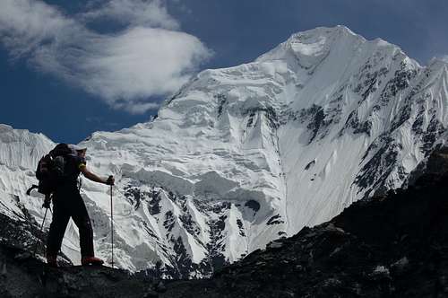
 Shimshal Whitehorn (right) as viewed from above the meadow on route to base camp
 |  Shimshal Whitehorn's NW ridge from high camp at around 4600m
 | 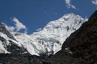 Shimshal Whitehorn from base camp
 |
What's in the Name?
The mountain has been referred to as Adver Sar, Shimshal Weisshorn and Shimshal Whitehorn. Adver Sar is the mountain's local Shimshali name. The name "Shimshal Weisshorn" is the informal name used by Stephen Venables in his report in the Alpine Journal (1985) on his and Dick Renshaw's failed ascent by the North Ridge. The name was adopted because the mountain reminded Venables of Weisshorn in the Swiss Alps. It may be that the North-West face of Shimshal Whitehorn Reminded him of the South-East face of Weisshoen. The name Shimshal Whitehorn has grown from this as a translation and is the name most commonly adopted. Locals seem to care little whether the mountain is called Adver Sar, Weisshorn or Whitehorn so long as expeditions keep visiting their village to climb the mountain! Shimshal Whitehorn (Pakistan)
 |  Weisshorn (Switzerland
 |
The Mountain's Height?

Ben climbing Shimshal Whitehorn's Couloir of 1000 gutters
Following the initial reconnoitre and attempt by Venables and Renshaw the height of Whitehorn was generally considered to be c.6400, as quoted by the Swiss map which probably did not survey the mountain's height properly. Google Earth suggests the peak is around 6536m. The height quoted on this page is based on altometer readings of the 2006 German expedition.
Routes
The North-West Ridge
The North-West ridge was climbed by the British in 1986 during the first ascent of the mountain. They approached via the Malangutti and Madhil Glaciers. This ended in tragedy during the descent (see intro). Nobody has attempted the route since.
The East Ridge

Whitehorn (right) seen from high on Yazghil Sar to the east
This is often called the North-East Ridge but my maps shows it to have more of an Easterly bearing. The route was first completed by the Germans in 2006 but Scotsman Bruce Normand and New Zealander Richard Ackerley had previously climbed 99% of the route in 1999. Starting points were different with Normand and Ackerley gaining the East Ridge from a side valley north of the one that the Germans commenced from.
From the bivouak site at Parigoz (5600m), Normand and Ackerley climbed towards a shoulder (6300m) until they reached 6000m, at which point they quit the ridge and traversed left across the north face of the shoulder to reach a small snow basin below the east flank of Whitehorn. From here they climbed this flank to gain the upper East ridge. Poor snow conditions forced them to make a rising leftward ascent along the eastern flank. Ackerley fell to his death close to the summit. Normand thought he had reached the summit but upon seeing the Germans photos realised that there was a point 200m southwest that was approximately 30m higher. Normand graded his route as an Alpine AD.
The Germans made a base camp at 4500m in the Chu Kurrti valley from where their route climbed to a high camp at 5200m. From there they climbed steep ice (85°) to gain the East Ridge. From here they ascended the ridge to within 150m of the summit at which point the team were forced to traverse left on to the face as the ridge contained too many crevasses towards the top. A further six rope lengths of 90° steepness, rock 3–4 were required to reach the summit. An excellent topo of the route is available here
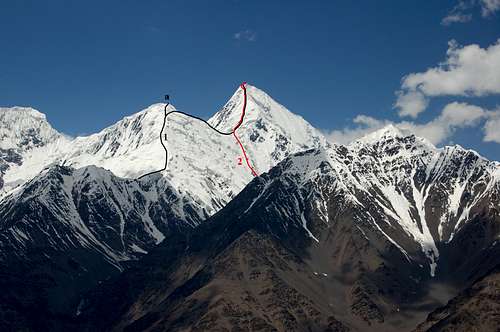
1999 and 2006 routes on the East Ridge
The North Ridge
The North Ridge
The North Ridge is Shimshal Whitehorn's most difficult and most exposed and remains unclimbed despite a number of attempts. Most of the problems occur in the lower half of the ridge which is very knife-edge and guarded by crevasses. The ridge is also heavily corniced. It is 1.25km in horizontal length. It can be gained either via the Madhil Glacier which is a subsidiary Glacier of the Malangutti Glacier, or via the Couloir of 1000 Gutters, which climbs from the Adver Valley to the North.
The first to attempt it was Dick Renshaw and Stephen Venables in 1984. They approached via the Malangutti and Madhil Glaciers but were thwarted by 30 hours of continuous snowfall. The pair had made a first ascent of Corner Peak (c.5600m) immediately prior, which lies at the end of the North-West Ridge.
In 1986, an Irish team attemted the North Ridge but aborted the attempt just past the 5300m subsidiary summit.
In 2005, a French team climbed the Couloir of 1000 Gutters but were unable to make much headway up the North Ridge due to poor snow conditions. For fear of rock fall, rather than descend the couloir by which they had climbed, they descended to the Madhil and Malangutti Glaciers.
In 2006, a British trio, which included myself, attempted the North Ridge via the same couloir as the French. Having climbed the couloir we were unable to make progress on the North Ridge due to bad weather. A trip report is available here.
 Couloir of 1000 gutters
 |  View down Couloir of 1000 Gutters
 |  View to top of Couloir of 1000 gutters
 |  Near top of Couloir of 1000 gutters
 |  Desending the Couloir of 1000 Gutters
 |  Couloir number two
 |
The South Ridge
This is the easiest ridge to climb on Shimshal Whitehorn but has the longest approach.
The North-East Face

Shimshal Whitehorn's North-East Face from our bivi sight at 4600m
This is usually referred to as the North Face however it's orientation is actually to the North-East. The face would be a tough, commiting, and often dangerous undertaking. It is around 1500m, approx 60 degrees steep (steeper towards the top) and overhung by cornices in the upper half of the face. There is also a large serac at the top of the face that would make a direct ascent difficult and it may be easier to bear right to join the North Ridge at some point. The lower half of the North Ridge is very knife edge so it is important to aim for the upper half of the ridge should this line be taken to avoid problems.
The only person to attempt the face is Ben Cheek who subsequently went missing - presumably avalanched during the ascent.
Getting There
Shimshal Whitehorn (right) at nightime from our base camp at around 4400m
Travel to the Northern Areas
Islamabad is the nearest international airport with flights arriving from around the world. Gilgit is the largest town in the Northern Areas served by regular transport from the north and south.
Domestic flights
PIA fly daily between Islamabad and Gilgit tickets can either be booked via their ticket offices or via their website. One-way fairs are currently Rs1590 with little discount for return trips. During bad weather planes may be grounded at short notice. Availablity is also a big problem. There are also daily flights to Skardu which operate a higher percentage of the time.
Buses
Buses run daily between Rawalpindi's Pir Wadhai bus station and Gilgit, and vice versa. Buses leave throughout the afternoon and arrive mid-morning next day. Book tickets in advance if poosible to avoid a bone jarring, sleepless ride on the back seat. Travel along the KKH is anything but predictable and landslides, mudslides, rock fall and even avalanches can sever it for hours, days or weeks at a time. Due to Tribal tensions in the Kohistan buses were travelling in convoy for a significant stretch of the journey further lengthening an already long journey. NATCO and Masherbrum both run buses daily with a limited number of seats available at student discount.
The Northern Areas can also be reached from China with the trip from Kashgar to Sost taking 2 nights with an overnight stop in Tashkurgan. Hi-Ace vans ply the route between Sost and Gilgit throughout the day leaving as soon as they are full. There is now a direct bus between Tashkurgan and Gilgit, however, if travelling from China, it is better to buy a ticket to Sost only then take local transport to Gilgit as the international bus sits in the customs yard at Sost for a couple of hours while luggage is checked before continuing to Gilgit.
Reaching Shimshal
The Jeep track to Shimshal was completed a couple of years ago and it is now possible to travel from Passu on the KKH in a couple of hours. There is a daily public Jeep although this does not seem to run at a regular time and I have often had to hire a private Jeep or wait a day. Passu-Shimshal special hires cost around Rs2500. All vehicles leave from the Shimshal restaurant which is a short distance north of the Batura Inn. Until last year vehicles left from the cluster of buildings in the centre of Shimshal however this is no longer the case.
 Jeep ride to Shimshal
 |  Water crossing on route to Shimshal
 |  Malanguti Glacier from the Shimshal Jeep track. Whitehorn is visible to the left
 |
Reaching the Mountain from Shimshal
The Adver Valley

Climb to Shimshal Whitehorn's base camp
From this valley the afforementioned couloirs and the north face can be climbed. The approach to base camp is relentless with little easy ground. A number of porters know the route to Whitehorn and there is no need to hire a guide for route finding. That said the route that our porters took us was considerably harder than a lower route that we later found that initially followed a water channel. It may be that the porters avoided the water channel route for fear of it becoming damaged. Whichever route you take you need to cross the glacier above its mouth from its true right (east) to its left (west) and then climb a treacherous loose scree slope to momentary easier ground. A small rock buttress then needs to be climbed before traversing more scree to a water source (in June) at around 4000m. This trickle of water is unlikely to be present except in the early season so bring plenty of water from Shimshal. The route continues climbing through a beautiful meadow above which there are amazing vistas of the mountain. Even for those not climbing the mountain it would e worth visiting this spot simply for the views alone. The way to base camp stays on the true left side of the glacier first descending and then climbing loose scree. The spot where the porters indicated was base camp seemed still be a long way from the mountain however the icefalls leading to the base of the mountain will be to tricky for porters to climb unless you have suitably equipped them with crampons and axes.
Since many people do not visit the base camp of Shimshal Whitehorn the porter stage system is a little unclear. We paid four stages to the base camp that the French used in 2005 however this was still a fair distance from the true ‘base’ forcing us to make a further bivi higher up the evening before climbing.
 Climbing to Shimshal Whitehorn's base camp
 |  Descent from Shimshal Whitehorn's base camp across seemingly endless scree
 |  Climbing to Shimshal Whitehorn's base camp
 |
Yazghil
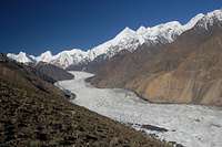
View south along the Yazghil Glacier to the Hispar Muztagh
This is the glacier that flows south-north to the east of Whitehorn. I have not trekked all the way down it but know that it has a reputation for being heavily crevassed. A selection of locals will no doubt know the route as the Upper Yazghil glacier is the staging post for a number of challenging north face climbs in the Hispar Muztagh. It probably possible to trek along the ablation valley and along the immediate western edge of the glacier for most of the way but check with locals first.
Mountain Conditions

Shimshal Whitehorn at night from base camp at 4400m
For many people visiting Pakistan's Northern Areas for the first time the warm summer's take time to adjust to. In Gilgit time temperatures regularly stay in their 30s during the summer and whilst it is cooler in the mountains it can still be uncomfortable at times. On days where there are no clouds a single layer will surfice and measures need to be taken to prevent sun burn. Weather can change quickly with fresh snow falling at any time in the year or heavy rains at lower altitudes. Come prepared for a range of climates.
Nights are generally warmer during the climbing season compared to destinations such as the Pamir, Tien Shan or Napalese Himalaya and an early start when climbing is usually imperative to avoid soft snow in the afternoon. It is not usual for there not to be a proper freeze at night leading to poor snow conditions under foot. At the top of the couloirs snow conditions can be particularly bad with hard, sugary ice beneath.
Red Tape
Permits
No permit is required to climb the mountain as it is under 6500m (see table below). The peak is not in a restricted area and no permit is required to visit Shimshal. Consequently there is no need to be accompanied by a guide unless so desired. A liaison officer is also not required. Early attempts were down so illegally as prior to 2001 climbing permits were required to climb all mountains in Pakistan. The relaxing of restriction in an attempt to encourage climbers to return to Pakistan has considerably reduced the bureaucratic requirements to climb the mountain.
| Elevation | Normal Fee | Fee for 2016 | ||
| Expedition royalty | Additional royalty per person | Expedition royalty | Additional royalty per person | |
| 7501 - 8000m | $400 | $50 | ||
| 7001 - 7500m | $250 | $40 | ||
| 6501 - 7000m | $140 | $20 | ||
| Up to 6500m | No fee | No fee | ||
Royalties per expedition are based on a party of 7. Persons additional to this number will be subject to an additional royalty fee.
Visas

Top of the Couloir of 1000 gutters
A valid visa is required. Visas are NOT issued at the airport and must be obtained prior to arrival. Some embassies such as those in Central Asia are reluctant to issue visas and advise you to obtain them from your home country. A single-entry tourist visa is valid for 3 months from the date of arrival in Pakistan and for 6 months from the date of issue. Some visas are only valid for 3 months from the date of issue so check if necessary when applying. Visa prices vary. Americans pay the most for their visa whilst Japanese get theirs free! Visa extensions and re-entry stamps used to almost impossible to obtain however the process has become remarkably easier in the last few years. Gilgit DC is a good place to try.
Camping and Accomodation
Accomodation in Shimshal

Shimshal village
Accommodation in Pakistan is extremely cheap costing as little as a dollar for a bed in some hotels. There are currently two places to stay in Shimshal. I have always stayed at the Sifat guesthouse, which is located just south of the newly built school on the northern edge of the village. The guesthouse is run by a friendly man by the name of Ferman who prepares good food and is very helpful with respect to arranging porters for guests. He also has good knowledge about the area. The second accommodation option is a newly built small hotel (and still being built as of June 2006) also near to the school. It is run by a Shimshali who has previously climbed Nanga Parbat and I think accompanied the Germans on their expedition. I have not stayed at the hotel however I have met the owner who has an excellent knowledge of the mountains in the local area.
 Shimshal village
 |  Shimshal village
 |  Shimshal Whitehorn as viewed from a hill top above the village of Shimshal
 |
Camping
Base Camp and high camp
Base camp is around 4400m and a couple of hours away from where the climbing really starts however it would be hard for porters to carry loads much further due to ice falls. Camp on the glacier away from the rock buttresses as there is rock fall constantly tumbling down the gullies between them. Plenty of clear water here.
We laid a high camp on a broad flat area before the last icefall. Again, plenty of clear water here.
Camping Fuel
Kerosene is widely available in bazaars and can often be found in smallers villages. Pakistani kerosene burns sootily so be prepared to clean your multi-fuel stove regularly. White gas is not available and denatured alcohol is available only in Rawalpindi and Islamabad.
Gas stove cannisters are sold in the outdoor shops on Gilgit's main high street. They are often refilled so don't expect the usual butane/propane mix. They are generally available in sufficient number for a medium sized expedition.
Food Provision
There is no need to bring food supplies from your home country as sufficient provisions can be found in Gilgit. Grocer shops sell staples such as pasta, dal, rice and porridge. Fresh fruit is of poor quality in Gilgit and likely to turn to mush in your rucksack before even reaching base camp. Dried apricots and mulberries and readily available and make for a good snack.
Shifkiten Sar

Shifkiten Sar (ca 5700m)
Summit
Shifkiten Sar is a small ca 5700m peak at the end of Shimshal Whitehorn’s North Ridge. The peak’s prominence is only about 100m above the North Ridge, hence why I have not dedicated a separate page to the peak. The have been ay least four ascents. It was first climbed in 1986 by the British group who subsequently made the first ascent of Shimshal Whitehorn. Previous to this ascent, an Irish group had made a failed attempt at Shifkiten Sar’s North Ridge. Qudrat Ali has also climbed it twice, in 1996 and 2006. I climbed this peak in 2006 from the Adver Glacier from the North together with Peter Thompson. The easiest way to climb the peak is via the Madhil Glacier which branches off the Malangutti Glacier. A more difficult way is the route we route in 2006 via the Couloir aux Milles Rigoles.
Maps
The best maps of Pakistan are the 1:50,000 and 1:100,000 Russian maps. They are not cheap however and I would not say they are a requirement for climbing in Pakistan as glacial routes often change from season to season anyway. A more readily available map is the orographical map produced by the Swiss Foundation for Alpine Research. The scale is only 1:250,000 however I have found it serves its purpose for general route finding and is particularly good for identifying peaks (although not all the surrounding peak heights in the area have been properly surveyed). An AMS map also covers the area of Shimshal Whitehorn (NJ 43-15) however it is inaccurate and few peak heights have been surveyed. The Leomann orographical map (1:200,000) is the most readily available map for but is also particularly useless.External Links
Matthias and Alexandra Robl Their website contains some excellent photos and topos of their route. English version available hereExcellent photos from the 2005 French expedition
2005 French trip report (translated version) Note there are four chapters. The original French language version is also available.
Matthieu Paley has produced an excellent brochure on Shimshal for Pakistan's Ministry of Tourism. It is available online here.
There are also some excellent photos of Pakistan's Northern Areas on Matthieu's own website here.