|
|
Mountain/Rock |
|---|---|
|
|
38.90700°N / 105.1243°W |
|
|
Teller |
|
|
Hiking |
|
|
Spring, Summer, Fall, Winter |
|
|
10605 ft / 3232 m |
|
|
Overview
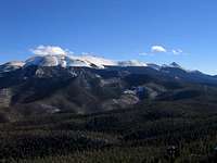
Raspberry Mountain stands above the small, gold boom town of Divide. It's not the highest mountain in the area, or very tough to climb, but it's special because of access and the views from the top. It offers fantastic views of Pikes Peak, Teller County, the Tenmile/Mosquito Ranges, and the Sawatch Range.
This mountain is easy accessible, and offers an easy hike-up route to its rocky summit. It is a great day trip for Teller County and Colorado Springs residents. It's a great trail running route in the summer, a great hike anytime, a great mountain bike route, and a great snowshoe or cross country skiing route in the winter and early spring. The standard route takes you through beautiful Pike National Forest Pine and Aspen, and leads you to a boulder strewn summit of the familiar pinkish Pikes Peak region rock.
This area of the Pike National Forest is quite popular, although the route to Raspberry Mountain is not nearly as popular as the Crags Campground area, several miles up the Upper Fourmile Road.
Getting There
The trailhead for Raspberry Mountain is on the Upper Fourmile Road, just south of the center of Divide.
Travel US 24 to the town of Divide, and turn south on CO 67 South (not to be confused with CO 67 North, which goes from Woodland Park, 8 miles away).
Go 4.25 miles from this turn to a poorly signed left turn onto the Upper Fourmile Road. On the way, you will pass a turn for Meuller State Park. Once you pass the park, look sharp for a sign that says, "Rocky Mountain Camp," and then another sign 100 meters from there for, "Crags Campground." Turn left here. There is a ranch here with horses. Cross a small bridge, and begin to travel uphill on the dirt road. The road is rough, but passable for passenger cars. If you travel here in winter, expect the road to be plowed, but don't count on it. This road gets icy. This road also goes to the popular Crags Campground and the trailhead for the alternate trail to Pikes Peak.
Travel 1.1 miles up this road until you reach a sharp switchback. You will see a gate straight ahead with a small pulloff. Park here. This is the trail head. The road beyond the gate is prohibited to motor vehicles.
Red Tape
There is no red tape for this mountain. If the trailhead parking is full, try to park off of the main road. There is another small parking area up the road about 200m.
When To Climb
Raspberry Mountain can be climbed all year round. Summer climbers will enjoy an easy hike or can use a mountain bike, while winter climbers can enjoy a fine snowshoe or cross country ski to the top.
In winter, standard winter gear is appropriate. There is no avalanche danger along this route, although wanderers off the standard trail may encounter terrain traps. Use your judgment.
A map and compass may be helpful on this route. Most of the trail is in deep woods, with several old mining trails and roads intersecting the main one. It isn't hard to stay on route, but everyone makes mistakes. Usually, however, you can find Pikes Peak through the trees and use it as a giant navigational aid.
Camping
There is a formal campground a few miles up the road at the Crags Campground . Access may be difficult in the winter. This campsite is a fee area.
Mountain Conditions
NOAA Weather Link.
You can contact the Pike National Forest Rangers at 719-636-1602 for current trailhead conditions and Pike National Forest conditions.
This part of the front range typically gets less snow than the rest of Colorado, but most of the route will be covered in snow from December to March.


