
-
 17328 Hits
-
 81.84% Score
-
 14 Votes
|
|
Mountain/Rock |
|---|---|
|
|
38.79310°N / 105.0547°W |
|
|
Teller |
|
|
Hiking |
|
|
Spring, Summer, Fall, Winter |
|
|
12397 ft / 3779 m |
|
|
Overview
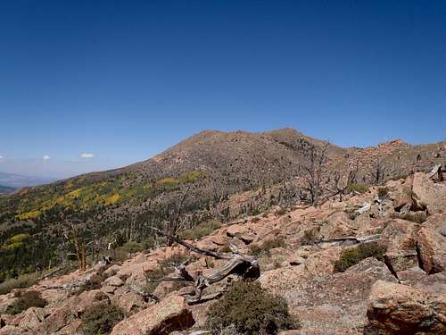
Approaching Sheep Mountain from the Southeast
Sheep Mountain is a strong, broad peak rising almost due south of Pikes Peak (14,110 feet / 4301 meters) in Teller County, Colorado. The mountain is surrounded by numerous reservoirs serving the Pikes Peak region. The scenery along the summit plateau is very reminiscent of the Lost Creek Wilderness Peaks, specifically Bison Peak (12,431 feet / 3789 meters), but a bit closer to home for residents of the Colorado Springs area.
This is a beautiful, wild peak that will leave you feeling miles away from civilization, while being relatively close to home base. The southeastern slopes and approach are characterized by an unreal ghost forest dotted by weathered outcrops of Pikes Peak granite. Despite the very common name (Sheep Mountains are absurdly numerous in Colorado), this is a very, very special place.
Rank: 1073rd highest peak in Colorado
Prominence: 567 feet
USGS Quad: Pikes Peak
Planning Maps: 1) Pikes Peak Atlas 2) Trails Illustrated #137 Pikes Peak | Cañon City
Rank & Prominence: Lists of John
 |  |  |
Getting There
 |  |  |
Sheep Mountain can be reached either by traveling cross-country from the Pikes Peak highway or via FS 376 toward the Utilities 4-way.
•A fee is required to utilize the Pikes Peak Highway and the road is subject to seasonal closures.
•FS 376 is graded for 2-wheel drive vehicles and plowed throughout the winter (for the most part). From here, snow conditions permitting, it is possible to continue on FS 376A (after a water crossing) for a few miles with sufficient ground clearance (or a disregard for lower body damage on your truck).
 |  |  |
Red Tape

Almagre Mountain and "Almagre Mountain South"

Almagre Mountain and "Almagre Mountain South"
| There exists little or no red tape in this part of the National Forest, and this peak can be accessed without fees or permits. Please follow LNT (Leave No Trace) principles: 1.Plan Ahead and Prepare 2.Travel and Camp on Durable Surfaces 3.Dispose of Waste Properly 4.Leave What You Find 5.Minimize Campfire Impacts 6.Respect Wildlife 7.Be Considerate of Other Visitors |
 Almagre Mountain and "Almagre Mountain South" |  Almagre Mountain and "Almagre Mountain South" |  Almagre Mountain and "Almagre Mountain South" |  Almagre Mountain and "Almagre Mountain South" |
Camping & Lodging

On the summit

Broad summit plateau

Pikes Peak and upper Beaver Creek

The summit
Rustic car camping and backcountry camping can be throughout the surrounding Pike National Forest. Be forewarned that the proximity of this area to the urban I-25 corridor means that crowding can be an issue, especially in the summer, and that unsavory characters are known to frequent this area. Be prepared for heavy ATV use, large crowds, drunkenness and casual firearms usage without a mind toward NRA-recommended safety precautions.
FS 376 & FS 376A: Due to private property holdings in the area as well as relatively high travel (recreation and utilities use), camping in the western approach (Beaver Creek) drainage is limited. There are spots here and there for 4x4 camping along FS 376A.
Hotels, Cabins, B&Bs
Old Colorado City
Nearby Old Colorado City has an assortment of lodging options, old and new, for all budgets. Restaurants, bakeries and shops are within strolling distance from many lodging facilities.
Manitou Springs
Manitou Springs lies at the foot of Ute Pass. This colorful, eclectic town offers a wide range of lodging options including old-style motor cottages and cabins, retro family-run motels, charming B&Bs and modern chain hotels. Shopping and dining are within walking distance of most Manitou lodging. Visit the a Manitou Springs Visitors Website for more information on lodging in the area.
Colorado Springs
The hotel options in Colorado Springs are virtually limitless. If you are the 5-star luxury type, be sure to check out The Broadmoor, which is extremely convenient to the eastern terminus of Old Stage Road.
Weather & Seasons

Northwest from the summit

Southeast along summit ridge

Summit Cairn & Register

Angel frolicking
| Detailed weather information can be found by visiting the website for the Pikes Peak Cog Railway. | Sheep Mountain is certainly doable in the winter months thanks to the plowed FS 376. Keep a sharp eye on snow conditions and choose your route carefully, as Colorado snow is infamous for its instability. Summer months bring heavy Jeep & ATV traffic to the dirt roads surrounding Sheep Mountain, and Old Stage Road is crawling with teens blaring obnoxious music, drunks shooting into thin air (no, I’m not making this up) and tourists nervous about damaging their rental car on the potholes and ruts. Spring access to the summit would depend on the year’s snowpack; a heavy snowpack would mean deep drifts of soft, late-season snow lodged in the trees. This is a great mountain for a late summer / early fall visit. Though possibly cold and windy, the days are likely sunny and the tundra is ablaze in autumn color. |  Click for weather Click for weather |
Angel taking a nap
 |  |  |