
|
|
Mountain/Rock |
|---|---|
|
|
36.31168°N / 111.95006°W |
|
|
Spring, Summer, Fall, Winter |
|
|
8424 ft / 2568 m |
|
|
Overview
Saddle Mountain has the rather esoteric distinction of being the highest summit INSIDE of the Grand Canyon. Located off the eastern edge of the North Rim, Saddle Mountain towers above the famed Nankoweap Trail, an old Native American route improved upon by John W. Powell himself. In fact, Powell may have made the first ascent of Saddle Mountain himself in the 1880s, making it one of the first summits with a recorded ascent in the Grand Canyon.
Although the majority of the summits off the north rim are quite brushy, the climb of Saddle Mountain utilizes the Nankoweap Trail for a large portion of the approach, with only a few hundred feet of steep brush to contend with, and not much in the way of route-finding difficulties. The summit is capped with a large summit cairn and benchmark placed in 1934, with views to the south across the Nankoweap drainage and eastern Colorado River through scattered trees.
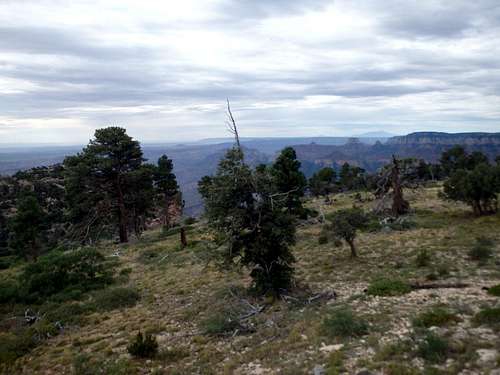
Saddle Mountain Summit Plateau
Getting There
Saddle Mountain can be approached from two different trailheads- the Saddle Mountain Trail off the North Rim, and the House Rock Valley Trail, which is lower in elevation and provides winter access.
For the Saddle Mountain Trail: From the town of Jacob Lake, drive south about 26 miles until reaching Kaibab Lodge. Just past the lodge are a pair of Forest Service roads, with FR 22 going right towards the Kaibab Plateau HP, and FR 611 headed towards Saddle Mountain and Marble Canyon Lookout with a sign labeled "Viewpoints." Turn onto FR 611 for 14 miles, ignoring the various side roads including the signed turn off for the Marble Canyon Overlook. The dirt road is in decent shape and should be manageable by most passenger cars with a bit of patience. The road ends at a turn around and the trailhead for the Saddle Mountain Trail.
For the Rock House Valley Trail: From the town of Marble Canyon, drive west for 21 miles and turn left onto Buffalo Ranch Road with signs for the Rock House Valley wildlife viewing. Follow this road for 29 miles ignoring the various side roads until the Rock House Valley Trailhead.
Route
Saddle Mountain Approach: The approach starts by descending the Saddle Mountain trail, which quickly reascends Point 8881', the highest point on the North Rim. The Saddle Mountain trail is a bit overgrown, so pants are highly recommended for this trail. The trail descends from this highpoint over and around several bumps along the ridgeline to the saddle between Saddle Mountain and the trailhead at about 7,500' where it intersects with Rock House Valley approach about 2 miles in. The two join together to become the Nankoweap Trail just above the saddle.
Rock House Valley Approach: From the trailhead parking area at about 6500', follow the trail for 2.5 miles as it ascends a north ridgeline to the saddle where it meets the Saddle Mountain Trail coming off of the north rim. Although you start the day with an ascent, the total elevation gain between the two approaches is basically a wash since you'll need to climb back up to the rim on the way out.
![The brushy class 2 crux]()
The brushy class 2 crux
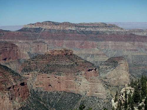
![View south from the summit cairn]()
View south from the summit cairn
The Climb: From the signed start of the Nankoweap Trail, continue along for another 100 yards to the low point of the saddle. Leave the trail before starting down the switchbacks, weaving through juniper and manzanita aiming for a prominent Western fin of Coconino Sandstone coming off the Saddle Mountain summit ridgeline. Contour around the ridgeline to the north around a small detached pillar, aiming for a notch in the sandstone above. The crux of the climb is just past this small detached pillar where the terrain becomes steep and brushy until you can break through the weakness in the sandstone above. The notch is easy class 2, the hard part is the brush and occasionally loose talus underneath. Once on the ridgeline, the brush clears considerably, as does the steep grade. It's easiest to more or less follow the ridgeline with various game trails over several rounded false summits about another mile to the high point marked with an oversized summit cairn. A short walk downhill past some scraggly junipers and pinyon allows better views across the Nankoweap drainage and a large portion of the Eastern Grand Canyon.
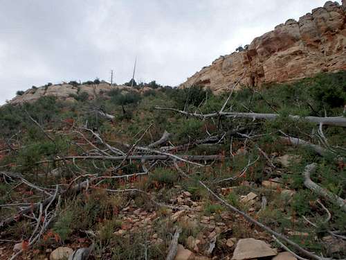
The brushy class 2 crux
Red Tape
View south from the summit cairn
Admission to GCNP is $30 for 7 days, although this trail starts on NFS or BLM land and it's not like anyone is standing at the boundary near the start of the Nankoweap Trail to collect. If visiting the park proper, I highly recommend the "America the Beautiful" Pass for $80, which covers the entrance fees for all federally managed parks and land for one year.
No additional permits are needed unless you're planning on incorporating this into a backcountry trip, and even then the park/forest service boundary is split along Saddle Mountain, and you could technically legally camp on Saddle Mountain without needing a park service permit if you keep to the north side, not that anyone would ever be around to check.
When to Climb
As with most hiking in Arizona, Fall and Spring are the best. The north rim is one of the few parts of the state with reasonable temperatures in the summer, although the trail is waterless and there is a strong potential for afternoon thunderstorms daily. The approach from the Saddle Mountain Trailhead off the north rim is gated off from Jacob Lake in the winter, although the approach from Rock Valley is open year-round. The north facing slopes will likely hold snow in the winter given the elevation.
There is plenty of places for camping at large in the National Forest just outside the park including the Saddle Mountain Trailhead, where you can camp directly on the rim. The Demotte Campground is located near the Kaibab Lodge just near the turnoff onto FR 611. There is also several developed campgrounds in Jacob Lake, as well as the North Rim campground within the park.
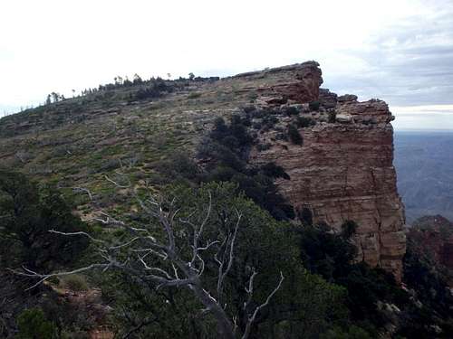
Saddle Mountain from the south
My trip report: The Mountains Are Calling