
-
 56495 Hits
-
 91.99% Score
-
 37 Votes
|
|
Area/Range |
|---|---|
|
|
53.12020°N / 119.13918°W |
|
|
Hiking, Mountaineering, Trad Climbing, Ice Climbing, Mixed, Scrambling, Skiing |
|
|
Spring, Summer, Fall, Winter |
|
|
12972 ft / 3954 m |
|
|
This is work in progress.
Thank you for your patience.
Overview
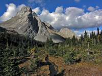
Mount Birdwood in Kananaskis Country
Canadian Rockies is probably the most impressive section of the Rocky Mountains. It is oriented southeast to northwest, along the Continental Divide for about 600 km with a breadth of about 120 km.
This height of land separates rivers flowing to the Atlantic and Arctic Oceans from those flowing to the Pacific Ocean. The Canadian Rockies actually feature a hydrographic apex or triple divide with the Columbia Icefield’s summit: Meltwater from Snow Dome (3459m) flows down the Athabasca and Mackenzie Rivers to the Arctic; the North Saskatchewan and Nelson Rivers to the Atlantic; and the Columbia River to the Pacific. A phenomena that occurs at only one other known place on the globe.
Canadian Rockies borders are reasonably clear and delimit the continuously alpine section of the Rockies in the Canadian territory (also known as the Continental Range). The northern limit is McGregor Pass where McGregor River and kakwa River have their headwaters (Kakwa Provincial Park) and where the Far Northern Rockies start. The southern limit is the Crowsnest Pass Cross-Strike Discontinuity close to the American border where the Central Montana Rocky Mountains start. The eastern edge is where the range rises directly from the Great Plains (Prairie). The western boundary is the Rocky Mountain Trench, a broad rift valley home to the Columbia River, dividing it from the older Columbia Mountains.
This range provides all manner of adventure from easy hiking trails to extreme Alpine routes. The highest point is Mount Robson (3954m). Although towering bellow the psychological bar of 4,000m (13,000ft) the Canadian Rockies are truly one of the great mountain ranges of the world and are unique in many ways. They feature countless impressive craggy and / or glaciated peaks, technically challenging and in a reasonably remote wilderness where moose, elk, mountain goat, lynx and bear roam free.
Mountain Ranges
overthrust mountain (Mount Rundle)
Foothills
The Foothills are the eastern-most ranges of the Canadian Rockies and have a breadth of 25-40 km. They are characterized by ridges of sandstone where summits are often dome like. The rolling Foothills have summits towering beyond 2000m.

sawtooth mountain (Mount Ishbel)
Front Ranges
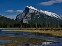
The Front Ranges are immediately west to the Foothills. They are characterized by long limestone ridges. Here, the rock formations have been inclined upwards and eastwards over the western edge of the Foothills they dominate by 1000m. Their limestone Strata usually display a pronounced drop to the southwest, as overthrust mountains (e.g. Mount Rundle, Sunwapta Peak) are typical of these ranges. Sawtooth mountains (e.g. Mount Ishbel) are another mountain type common here and dogtooth mountains (e.g. Mount Louis, Mount Birdwood, Mount Edith) could also be found. The average elevation of the Front Ranges is above 2500m and the highest point is Mount Brazeau (3470m)
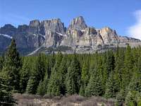
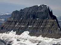
castellated mountain (Castle Mountain)
Eastern Main Ranges (Park Ranges)
Here are most of the highest mountains and widest glaciers and icefields that make Canadian Rockies famous worldwide. The Eastern Main Ranges, also called the Park Ranges, sculpt the Continental Divide and dominate the Front Ranges by about 500m. They too, are characterized by layered sediments. However rather than being folded and inclined, the layers are almost horizontal. The formations are of resistant quartzite, limestone and dolomite separated by weak shale, resulting in “layer-cake” shape of castellated mountains (e.g. Castle Mountain, Mount Temple, Pilot Mount) so characteristic of the Eastern Main Ranges. Horn mountains (e.g. Mount Assiniboine, Mount Athabasca, Mount Fryatt) created by the effect of several cirque glaciers surrounding a mountain, are also common here.

horn mountain (Mount Assiniboine)
Northern Park Ranges (under construction)
(from McGregor Pass to Yellowhead Pass on Yellowhead Highway / Highway 16)
Sir Alexander Area
Morkill - Jackpine Area
Resthaven Area
Snake Indian - Victoria Area
Robson Area
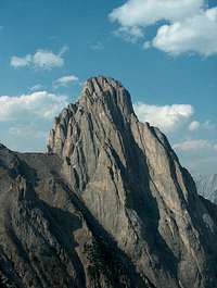
dogtooth mountain (Mount Louis)
Central Park Ranges (under construction)
(from Yellowhead Pass on Yellowhead Highway / Highway 16 to Kicking Horse Pass on Trans-Canada Highway / Highway 1)
Trident - Ramparts Area
Hooker Area
Clemenceau Area
Columbia Icefield Area
Lyell and Mons Area
Freshfield Icefield Area
Wapta Icefield Area
Southern Park Ranges (under construction)
(from Kicking Horse Pass on Trans-Canada Highway / Highway 1 to Crowsnest Pass on Highway 3)
Bow - Ball Area
Assiniboine Area
Royal - Joffre Area
Harrison Ranges
Western Main Ranges
The Western Main Ranges are found west of the Continental Divide. The mountains here are usually steep on the northeast and gentle on the southwest but are not aligned in such a regular manner as in the Front Ranges. With the noticeable exception of the impressive 900m high Rockwall, a limestone cliff that stretches along the northwest boundary of Kootenay National Park, these ranges are predominantly characterized by crumbly shale. Thus, more subject to erosion, the mountains display less angular appearance than in the Eastern Main Ranges. Dogtooth mountains are also found here (e.g. Spike Peak). The summits are typically close to 3000m in elevation and the highest point is Mount Goodsir South (3562m).
Western Ranges
The Western Ranges are a limited topographic unit running along the western margin of the Rockies from Golden to the south, between Columbia and Kootenay Rivers. Here, the rock formations have been tipped upwards and overturned past the vertical, resulting in a complex landscape that differs from the profile of Western Main Ranges mountains (steep on the northeast / gentle on the southwest). The highest peak of the Western Ranges, also called Kootenay Ranges, is Mount Sinclair (2662m).
Wilderness Conservation

Black Bear in Kootenay National Park
About 35,000 km2 of the Canadian Rockies Wilderness (an area larger than Maryland or Belgium) is preserved by means of national and provincial parks of which the most important ones are contiguous and interconnected.
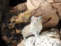
Pika in Yoho National Park
Canadian Rocky Mountain Parks (UNESCO World Heritage Site):
Banff National Park
Jasper National Park
Kootenay National Park
Yoho National Park
Mount Robson Provincial Park
Mount Assiniboine Provincial Park
Hamber Provincial Park
Other major provincial parks in the Canadian Rockies:
Elk Lakes Provincial Park
Height of the Rockies Provincial Park
Kakwa Provincial Park
Kananaskis Country
Willmore Wilderness Park
Summits and Routes
Emblematic Mount Alberta, first climbed by the Japanese expedition of 1925

tribute to the hard work and skills of the Swiss Guides (1898 to 1940’s): the Abbot Pass Hut (2,940m), built in 1922
Peaks above 3500m (high altitude):
Mount Robson 3954m
Mount Columbia 3747m
North Twin Peak 3684m (Twins Tower 3627m)
Mount Clemenceau 3658m
Mount Alberta 3619m
Mount Assiniboine 3618m
Mount Forbes 3612m
South Twin Peak 3566m
South Goodsir 3562m
Mount Temple 3543m
North Goodsir 3525m
Edward Peak 3514m
Ernest Peak 3511m
Mount Lyell 3511m
Mount Bryce 3507m
Rudolph Peak 3507m
Mount Kitchener 3505m
Peaks by park:
Summits and routes in Banff National Park
Summits and routes in Jasper National Park
Summits and routes in Kootenay National Park
Summits and routes in Yoho National Park
Summits and routes in Kananaskis Country
 tribute to the hard work and skills of the Swiss Guides (1898 to 1940’s): the Abbot Pass Hut (2,940m), built in 1922
Camping & Huts
In the parks and recreation areas, there are many campgrounds and campsites both near highways and in the backcountry. Refer to the relevant park site (above) for details.
In the Canadian Rockies, the Alpine Club of Canada maintains a network of backcountry huts ranging from remote bivi shelters to well equipped log cabins. Parks also run few backcountry lodges, cabins, huts and shelters; i.e. the Naiset Hut, the Hind Hut and the Bryant Creek Shelter, around Mount Assiniboine, and the Ralf Forster Hut on Mount Robson.
External Links
Digital topographic maps: Toporama (Natural Resources Canada)
Hikes in the Canadian Rockies: Waputik, Illustrated hiking trails of the Canadian Rockies
Scrambles in the Canadian Rockies: Canada's Mountains
Alpine climbs in the Canadian Rockies: Climb Wild
Collection of databases presenting comprehensive information about the Canadian Rockies: Peak Finder
Getting There
The most convenient airport to get to the Canadian Rockies is Calgary International Airport.
The range is crossed east / west by two major highways. The Trans-Canada Highway (Hwy 1) crosses the Rockies at Kicking Horse Pass (1647m), linking Calgary to Vancouver through Canmore, Banff, Lake Louise and Golden. The Yellowhead Highway (Hwy 16) crosses the Rockies at Yellowhead Pass (1146m) linking Edmonton to Prince George through Jasper. These two highways are connected together between Jasper and Lake Louise by the infamous Icefield Parkway / Promenade des Glaciers (Alberta Highway 93 North), a 230 km long scenic road that parallels the Continental Divide and the high Park Ranges.
It is also possible to go to the Canadian Rockies by train with Via Rail, getting off in Jasper. Furthermore, Rocky Mountaineer provides 2 vacation train routes, from Vancouver to Banff / Calgary and from Vancouver to Jasper.
Red Tape
Most of the peaks of interest to climbers are in wilderness conservation areas where use of the backcountry is regulated. Refer to the relevant park site (above) for details. In the national parks there is an “entry fee” (in 2008: $9.80 / Adult / day, $19.60 / group / day) as well as a “backcountry use permit” for overnight / multi-day outings (in 2008: $9.80 / person / per night). Annual entry packages and seasonalbackcountry passes are also available.
If planning to stay overnight at one of the Alpine Club of Canada huts, it is possible to pay the backcountry use permit also to ACC while booking the hut. ACC will transfer the information to the park authorities and mention the permit on your receipt.
GMJ - Jan 19, 2020 8:24 pm - Voted 9/10
A few notes1. A few spelling errors! No big deal but worth correcting. 2. You're missing Waterton Lakes National Park in southern Alberta. 3. Geologically and physiographically speaking, the Canadian Rockies include Glacier National Park, Montana, which isn't clear from this article. 4. Another park has been added to the southern Canadian Rockies: Castle Provincial Park/Wildland Provincial Park. It's a very beautiful area and quite popular for hiking, but is a subject of much political conflict. See https://albertaparks.ca/parks/south/castle-pp/information-facilities/. A great hiking blog (not mine) with lots of information about the Castle is Dave McMurray's peaksandstreams.com. A few other parks worth mentioning is BC's Northern Rockies Provincial Park, the largest such park in the Rockies (http://www.env.gov.bc.ca/bcparks/explore/parkpgs/n_rocky/), Stone Mountain PP in northern BC (http://www.env.gov.bc.ca/bcparks/explore/parkpgs/stone_mt/), Alberta's side of the Kakwa (https://albertaparks.ca/parks/northwest/kakwa-wpp/information-facilities/) and Rock Lake-Solomon Creek WPP (https://albertaparks.ca/parks/central/rock-lake-solomon-creek-wpp/information-facilities/) 5. The Kananaskis Country link is out of date and should be https://albertaparks.ca/parks/kananaskis/kananaskis-country/ 6. This isn't really a correction, but shouldn't the 3500 m list be a list of the fabled 11000ers? Otherwise this is a really great page.