
-
 9922 Hits
-
 81.54% Score
-
 14 Votes
|
|
Mountain/Rock |
|---|---|
|
|
50.69765°N / 115.01578°W |
|
|
Mountaineering, Scrambling |
|
|
Summer, Fall |
|
|
9938 ft / 3029 m |
|
|
Overview
Tombstone Mountain is a substantial peak with a long and jagged summit ridge in the Opal Range of Kananaskis Country. The 3029 metre (9,938 ft) summit of Tombstone Mountain has several prominent towers along the summit ridge with large tilted slabs. This summit is tied with Mount Elpoca for the second tallest peak in the range. Named in 1884 by the proficient surveyor and explorer Dr. George Mercer Dawson, assumedly for these slabs that resemble tombstones. There is a significant southern outlier GR 407165 locally referred to as “Tombstone South” which recently has become very popular with scramblers.
First ascent of the mountain was in September 1975, by coincidence both the North and South summits were climbed the same day. The North summit is the highest point and the true summit. North summit first ascent by E. Grassman & party. Climbed from Jerram outlier/Tombstone Col, traversed up scree to North Ridge, ridge to summit. First Ascent of South summit by D. Forest, M. S. Forest. R. McGee, L. Michand, G. Boles & L. Kubbernus via South Ridge.
Double summit, triple summit, where’s the summit
Tombstone Mountain, like most Opal Range peaks, has a complex and broken summit ridge, with a series of tall towers of tilted slabs and deeply eroded strata low points. A few sources refer to Tombstone Mountain as a double summit, likely because when viewed from the summit of GR407165 (‘Tombstone South’) the visible highpoint has two towers (the South-East Tower and the South-West Tower). The long North-South summit ridge actually has three significant highpoints, clearly visible from the east or west. A mislabelled summit on the official topographic maps has created confusion about the location of the summit.
Local guidebook authors have tried to clear up this confusion. Alan Kane’s “Scrambles in the Canadian Rockies” Third Edition 1999, states, “The 82J/11 map edition 2 incorrectly shows Tombstone Mountain at 407165. Tombstone Mountain has a double summit and is actually 1.5 northwest. This scramble ascends the peak at the above coordinates, unofficially called Tombstone South". The famous “Green Book”, The Rocky Mountains of Canada South. 7 th edition. Boles, G.W., Kruszyna R. & Putnam W.L. (1979) states, “Tombstone Mountain (3035m) A long N S massif with 3 summits 8 km E of outlet from Lower Kananaskis Lake, 5 km SE of Mt. Blane. Name misplaced on lower mountain to the S on 82J11.”
 |
 |
 |
 |
|---|
Although very difficult to discern from the summit, and from surrounding peaks, the northern most highpoint is considered the true summit of Tombstone Mountain. After pouring over dozens of photos and a few video clips, I am suggesting cardinal points names for the 5 highest summit towers. North Tower, South-West Tower, South-East Tower, West Summit and South Summit (Mickey Mouse Ear).
Getting There

Area Map
Easy highway access from Highway 40 along the western edge of the Opal Range provides the best approach. Highway 40 does provide access from the Trans Canada Highway in the north, and continues south to the Longview area, but the southern section is closed for wildlife protection from December 1 to June 15 each winter/spring. Best vehicle access from Canmore/Banff or Calgary is via the Trans Canada Highway, south along Highway 40.
Access to the parking area, Elbow Lake trailhead, is affected by the road closure is not accessible by motor vehicle from December 1 to June 15. Park in the Elbow Lake parking lot, approximately 62 km south of the Trans Canada Highway. To access Tombstone Mountain you need to access upper ‘Piper Creek’ (unofficial name), which can be difficult as there is no official trail and a significant river crossing. Once in the upper drainage of ‘Piper Creek’, head north towards a high col (outlier of Mt. Jerram and Tombstone Mtn. col) about 5 kilometres from river crossing of Elbow River; only the North Ridge route requires access to the col, see route descriptions for other approaches.
Red Tape/Camping and Bivouacs

Elbow Lake
The parking area to access Tombstone Mountain is located in Peter Lougheed Provincial Park. Tombstone Mountain, and much of the approach, is located in the Elbow-Sheep Wildland Provincial Park. Peter Lougheed Provincial Park is a popular and busy recreation area hectic with front country users in the summer months.
Important Red Tape Update. As of June 2021, a mandatory user fee will be in place for Kananaskis Country - 90$ for an annual pass or 15$ for a day pass.
More information: https://www.alberta.ca/kananaskis-conservation-pass.aspx
A fee is required to enter, park or hike in Peter Lougheed Provincial Park. Within Peter Lougheed Provincial Park, backcountry camping, including bivouacs for climbing, are only allowed in designated campsites.
Backcountry camping permits are required at all designated backcountry campgrounds anywhere in Kananaskis Country. Random backcountry camping without a permit is allowed in most Wildland Provincial Parks, including Elbow-Sheep Wildland Provincial Park. A very popular campground with great views and a short approach is located on the approach to Tombstone Mountain at Elbow Lake. Permits can be purchased in person at Barrier Lake Visitor Information Centre and the Peter Lougheed Provincial Park Visitor Information Centre during normal hours of operation.
Up to date information about Peter Lougheed Provincial Park available at: Peter Lougheed Provincial Park
When to Climb
Typical Canadian Rockies situation with July and August providing the best conditions for high elevation climbing. Tombstone Mountain’s position in the dry front ranges extends the summer season and is usually dry from June to late October.
Approach
From the Elbow Lake trailhead (not accessible by motor vehicle from December 1 to June 15) take the very large trail (former road) to Elbow Pass and beyond to Elbow Lake. The lake is reached quickly as it is only 1.0 kilometre from the parking lot. The large trail continues north along the north shore of picturesque Elbow Lake. The trail soon splits into a hiker’s and horse’s trail, stay on the trail with bridges, this is the hiker trail. Soon spectacular views of the East Face of Elpoca Mountain are visible, including the striking ‘Elpoca Tower’ (GR 401140).
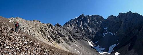
On the left side, north side, of the trail, the young Elbow River begins to cut a deeper and deeper sharp valley into the terrain. The sooner you head into the ‘Piper Creek’ valley, the less water and less steep creek bank you will need to negotiate. About 2.0 kilometres north of Elbow Lake (at approximately GR413140), a good flat section with small willows provides a point to cross the Elbow River.
 |
 |
 |
|---|
An excellent trail heads north/south in the ‘Piper Creek’ valley (I suspect pounded in by the numerous backcountry guided horse trips in the surrounding valleys). The trail is on the north creek bank, best way to find this trail is to head north (light bushwhacking) taking a straight line to the South Ridge of Tombstone South (GR407165). Cross ‘Piper Creek’ and keep heading north until you intersect the trail. Once on the trail, follow it north/north west upstream. All four routes are approached by ‘Piper Creek’, depending on intended route, head up valley, North West, to the base of chosen line.
Route Descriptions
The only published route information for Tombstone Mountain is in the “The Rocky Mountains of Canada South”, Boles, G.W., Kruszyna R. & Putnam W.L. (1979) guidebook and one trip report (R. Collier, R. Bonney and B. Saunders) online at bivouac.com. In August of 2003, Ben Sweet and I climbed a new alpine rock route on Tombstone Mountain, but we only reached the West Summit since we had to retreat due to thunderstorms.
 |
 |
|---|
- North Tower, Main Summit, North Ridge, Alpine II, 5.4
First Ascent of mountain in September 1975 by E. Grassman & party. Climbed from headwaters south west of Little Elbow River via ‘Piper Creek’ to Jerram-Tombstone Col. By coincidence north and south summits climbed the same day. Head north of col to gain scree slopes on north west slopes, up scree to upper rock North Ridge. Follow North Ridge with exposed and loose difficult scrambling (4th Class). Reach deep notch just north of summit, rappel into notch and climb slab/ridge to summit (5.3). Rappel back to notch, return climb north out of notch has solid rock with little protection (5.4). Descent same route.
- South West Tower, South Ridge, Alpine II, 5.4
First Ascent of route in September 1975 by D. Forest, M. S. Forest. R. McGee, L. Michand, G. Boles & L. Kubbernus. From Elbow River, party hiked into valley between objective and Elpoca Mtn. Meadow slopes ascended to cirque south of peak, slopes to left led to South Ridge, hiked to buttress, bypassed by large gully on the left (west) to notch. Descent over steep slabs and ledges to head a large gully. This gully system lead straight up from cirque, but viewed from below many turrets make it hard to tell where summit is located. Talus slope led up to base of final summit block. 1 ½ rope length of 5.4 then ridged followed to summit. (12m gap along ridge) 6.5 hours. Descent 1 long rappel off summit block, then gully system straight down to cirque.
- North Tower, Main Summit, South Ridge, Alpine II
First Ascent of route October 3, 1987 by Rick Collier, Bob Saunders and Reg Bonney. From Elbow Lake turn NW and followed the stream, commonly known as Piper Creek, to the head of the valley, an additional four kilometres. A trail exists on the N side (true lefthand) about 100' above the stream itself. Ascended the scree in the large bowl that trends NE. About three-fourths of the way up the scree toward the terminal wall, turn left (NW) into a wide couloirs. Follow couloirs with easy scrambling to a notch between a gendarme and the SW ridge of the objective. Traversed around a minor summit to the right to gain the main NW to SW ridge. A series of towers and notches with modest exposure were scrambled to the true N summit.
- West Summit, South Rib, Alpine II, 5.5
First Ascent of route August 2003 by Kevin Barton and Ben Sweet. From Elbow Lake follow same approach as South Ridge routes to large scree cirque south of peak. About half way up cirque, to climber’s left, is a prominent solid limestone rib that protrudes from the steep scree. Aim for base of rib. Gain rib with solid holds, but little protection, 5.3. Follow rib for about 100 metres with low fifth class climbing on solid slabby rock; we soloed this section. Rib steepens at a large bulge. Roped up here, two short pitches (about 45 metres each) of 5.5 rock with little protection. On top of rib, steep drop-off to reach notch between this highpoint and true West Summit. We bailed off the first highpoint and did not reach the true West Summit because approaching nearby thunderstorm. Rappelled off of first highpoint to scree field and descended scree to valley.
Reference
Boles, G.W., Kruszyna R. & Putnam W.L. (1979). The Rocky Mountains of Canada South. 7 th edition. New York: American Alpine Club, Alpine Club of Canada. Out of print
Collier trip report online at bivouac.com
Chillaxed Alpine Climbing in the Canadian Rockies
Tombstone Mountain - North Ridge, North Tower, Alpine II, 5.5