
-
 10995 Hits
-
 79.04% Score
-
 10 Votes
|
|
Mountain/Rock |
|---|---|
|
|
50.71434°N / 115.2887°W |
|
|
Mountaineering |
|
|
Spring, Summer, Fall, Winter |
|
|
10121 ft / 3085 m |
|
|
Overview
Mount Jellicoe is significant summit near the Continental Divide in the high country of Kananaskis Country. Jellicoe is a long north-south mountain with sharp and elongated ridges, steep faces and a lower angled southern slope. This major peak reaches 3075m (10,089 ft) and is flanked by major glaciers, the Haig and Smith-Dorrien Glaciers. The southern slopes descend into the Upper Kananaskis River drainage and the exciting Turbine Canyon, through which flows Maude Brook. Officially named in 1918 for Sir John R. Jellicoe, a commander of the British Grand Fleet from 1914 to 1916. Sir John Jellicoe led the Royal Navy into the Battle of Jutland during World War I. First recorded ascended in 1922 by E.W. Crawford, M.D. Geddes, W. Gillespie, M.P. Hendrie, N.D.B. Hendrie, but likely the summit was reached by a survey team of the Interprovincial Boundary Survey in 1913. The Interprovincial Boundary Survey determined the exact location of the boundary between the provinces of British Columbia and Alberta, mostly along the continental divide.

|

|

|
|
Mount Jellicoe from Mt. French North Face in shade |
Mount Jellicoe from Haig Glacier West Face |
Mount Jellicoe Southern Slopes |
Getting There
Very likely anyone visiting Mount Jellicoe will approach from Alberta and Peter Lougheed Provincial Park. A longer vehicle approach and hike is possible from British Columbia, but not likely a realistic choice for most. Best vehicle access from Canmore/Banff or Calgary is via the Trans Canada Highway, south along Highway 40. From the intersection of Highway 40 (Kananaskis Trail) and Highway 1 (Trans Canada Highway) travel south to the turnoff for Kananaskis Lakes (50 km) and continue onto the North Interlakes Parking Lot, 65 km from Highway 40/1 interchange.Access to North Kananaskis Pass, or the southern terminus of the Haig Glacier, would be from the busy summer trail along the north shore of Upper Kananaskis Lake, then heading north along the Upper Kananaskis River towards Turbine Canyon Campground, Maude Lake or North Kananaskis Pass. Maude Lake is approximately 17 kilometres from the trailhead at the North Interlakes Parking Lot. Overnight camping is available at Turbine Canyon Campground (15 km from trailhead) which requires a backcountry camping permit with prepayment and a reservation. This backcountry campground is very busy in the prime summer months.
Access to the eastern aspect of Mount Jellicoe requires extensive glacier travel and considerable approach time on these glaciers and should only be attempted by experienced mountaineers. Trailhead parking for the approach up French Creek and Glacier is located along the Smith-Dorrien road, approximately 20 km north of the Kananaskis Lakes area, at the Burstall Pass trailhead. Hike or ski the trail towards French Creek, head south along the creek to the French Glacier to the Mt. French/Mt. Robertson col (col approximately 11km from trailhead). The summit of Mount Jellicoe is about 2 km south of the col and access to the southern slopes is about 3 km from the col.
|

|

|
|
French Glacier just below French/Robertson Col |
View to French/Robertson Col from summit of Mt. French |
Skiing south from French/ Robertson Col |
Red Tape/Camping and Bivouacs
Once a true wilderness area, the backcountry regions of Peter Lougheed Provincial Park has become extremely busy and popular. This has required increased regulation of the backcountry in the last 10 to 15 years in an attempt to sustain the healthy ecosystem and wildlife populations. Peter Lougheed Provincial Park only allows backcountry camping in designated backcountry campgrounds and no random backcountry camping is allowed. Closest backcountry campground to Mount Jellicoe is Turbine Canyon.Up to date information about Peter Lougheed Provincial Park available at:
Peter Lougheed Provincial Park
Height of the Rockies Provincial Park is part of the British Columbia Provincial Park System and no permits or passes are required for climbing, parking or camping. Height of the Rockies Provincial Park is a wilderness area, without supplies or equipment of any kind. The park contains high concentrations of elk, mule deer, bighorn sheep, moose, cougar, black and grizzly bears. Be aware of wildlife and practice “Leave No Trace” ethics.
Up to date information about Height of the Rockies Provincial Park available at:
Height of the Rockies Provincial Park
When to Climb
Typical Canadian Rockies situation with July and August providing the best conditions for high elevation climbing. Mount Jellicoe’s southern slopes were an excellent ski ascent. Typically spring (April or May) is the best snow conditions for a ski ascent. Southern slopes would be a hike and a scramble (4 class) along summit ridge, best in summer or fall.

|

|

|
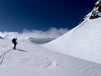
| Start of ski from Haig Glacier | Skinning up in the hot sun | Booting to the South East Ridge |
Approach
From the Turbine Canyon Campground head north, first along the Upper Kananaskis River, then eventually north-west towards in the drainage from the outlet of the Haig Glacier. Winsport Canada maintains a summer ski camp on the Haig Glacier with athletes approaching via Upper Kananaskis River trail, likely there is a good trail (coaches and staff are helicoptered in). One can gain the southern slopes without stepping on the Haig Glacier.From the Mt. French/Mt. Robertson col (col approximately 11km from the Burstall Pass trailhead) head south onto the Haig Glacier; admiring the steep West Face of Jellicoe while travelling. The summit of Mount Jellicoe is about 2 km south of the col and access to the southern slopes is about 3 km from the col. Easy glacier travel, but must be prepared for crevasses.
Route Descriptions
The only published route information for Mount Jellicoe is in the “The Rocky Mountains of Canada South”, Boles, G.W., Kruszyna R. & Putnam W.L. (1979) guidebook.

|

|

|
|
View to main summit from upper South East Ridge |
Raff returning from summit | Crux of South East Ridge |
- South Slopes/South East Ridge, Alpine I, Class 4
First recorded ascent of mountain by E.W. Crawford, M.D. Geddes, W. Gillespie, M.P. Hendrie, N.D.B. Hendrie in August 1922. From camp near Turbine Canyon to Haig Glacier then up long snow slope then steep scree to South East Ridge. Along loose rock of South East Ridge, two short chimney climbs lead to narrow ridge to summit.
Once on South East Ridge, views improve.

|

|

|
| View east to Opal Range | View west to Mt. Maude | View south to Mt. Beatty |

|

|

|
|
OSWB on summit of
Mt. Jellicoe |
Raff and Eric on summit of
Mt. Jellicoe |
View north over Haig Glacier |
- North West Ridge, Alpine II
First ascent July 1974 by D. Rudkin and D. Smith. A pleasant rock climb on good quality rock.
- West Rib/North West Ridge, Alpine II
First ascent August 1974 by B. Schiesser and group. From Haig Glacier climbed prominent West Rib on good quality rock to gain North West Ridge, then ridge to summit.
Reference
Boles, G.W., Kruszyna R. & Putnam W.L. (1979). The Rocky Mountains of Canada South. 7 th edition. New York: American Alpine Club, Alpine Club of Canada.Out of print