
-
 5745 Hits
-
 0% Score
-
 0 Votes
|
|
Mountain/Rock |
|---|---|
|
|
50.66312°N / 115.02712°W |
|
|
Alberta |
|
|
Mountaineering, Trad Climbing |
|
|
Spring, Summer |
|
|
9961 ft / 3036 m |
|
|
Overview
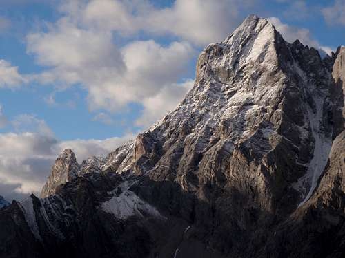
Elpoca Mountain is a prominent and impressive mountain; long, serrated shark fin like ridge running mostly north-south, presenting huge faces and buttresses to the west and east. At 3036 metres (9,961 feet), Elpoca Mountain is the second tallest mountain in the mighty Opal Range. This peak shares a north col with South Schlee (GR388157) (2800 m) and a west col with Gap Mountain (2667 m). Elpoca Mountain forms the southern end of the Opal Range. From Elpoca Mtn. summit to the South Schlee Col, there is about 350 metres of prominence and about 630 metres of prominence to the Gap Mountain Col.
Unlike most Opal Range summits, this peak is not named to honour the Battle of Jutland. Officially named in 1920, the name is combination of “El”, from Elbow Pass and Elbow Lake, both at the southern end of the mountain, and “Poca”, from Pocaterra Creek, which flows west from the base of the mountain. George Pocaterra was an explorer, hunter and trapper from the early 1900’s who explored and worked in the area. George’s wife, Norma Piper, was very active in the art’s community in Calgary in the 1930’s and the creek to the east of Elpoca Mountain is unofficially referred to as “Piper Creek”.
First ascent of the lower, southern outlier summit of Elpoca Mountain, was in 1960 by G.D. Elliot, H. Kirby, P.S. Scribens. First ascent of the highest, central, north summit, is unknown. Several local dedicated climbers recorded ascents of a gully on the East Face to the long South Ridge in the early 1990’s, but there was evidence of prior ascents. This East Face/South Ridge route is the standard route up the peak. The great northern couloir on the North Face was first climbed in June 2016, with the second ascent in June 2017. These are the only two documented routes.
Getting There
Best vehicle access from Canmore/Banff or Calgary is via the Trans Canada Highway, then south along Highway 40. From the intersection of Highway 40 (Kananaskis Trail) and Highway 1 (Trans Canada Highway) travel south past the Kananaskis Lakes turnoff, then to the Elbow Lake trail head.
Access to the parking area, Elbow Lake trail head, is affected by a seasonal road closure and is not accessible by motor vehicle from December 1 to June 15. Park in the Elbow Lake parking lot, approximately 62 km south of the Trans Canada Highway.
Red Tape / Camping and Bivouacs
Peter Lougheed Provincial Park is a popular and busy recreation area hectic with front country users in the summer months. Off the beaten track areas, like Piper Creek, are easy to find and often very wild, usually providing a solitary experience. Piper Creek is in the Elbow Sheep Wildland Provincial Park.
No permit or fee is required to enter, park or hike in Peter Lougheed Provincial Park or Elbow Sheep Wildland Provincial Park. The approach for both routes on Elpoca Mountain are relatively short and typically do not require a bivy, unless wanting to access better snow conditions in the early morning. Within Peter Lougheed Provincial Park, backcountry camping, including bivouacs for climbing, are only allowed in designated campsites. Elbow Lake campground provides an excellent base camp for exploring the Piper Creek valley. Overnight permits can be purchased in person at the Barrier Lake or the Peter Lougheed Provincial Park Visitor Information Centres during normal hours of operation.
Piper Creek is in the Elbow Sheep Wildland Provincial Park, which does not require camping in campgrounds and allows random camping if a camp is more than 1.0 kilometre from a designated backcountry campsite.
Up to date information about Peter Lougheed Provincial Park and Elbow Sheep Wildland Provincial Park available at:
Peter Lougheed Provincial Park
Elbow Sheep Wildland Provincial Park
Approach
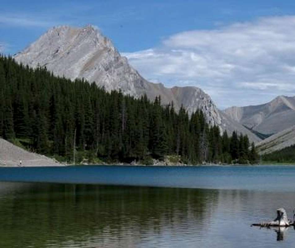
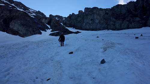
The trail to Elbow Lake is one of the busiest in Peter Lougheed Provincial Park and likely has the highest volume of users of any trail within the Opal Range. The distance to Elbow Lake is short, only 1.0 km to the lake, and provides the only backcountry campground in this part of the park. As well, the scenery is fantastic, the trail, though steep in parts, is well maintained and clearly signed. Also this trail provides access to the southern edge of the popular “Elbow Loop” trail, mostly for mountain bikers, equestrians and hunters in the fall.
East Face/South Ridge approach
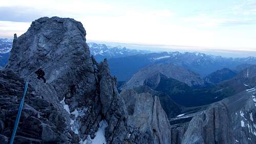
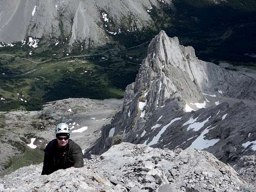
Approach to the standard route is from Elbow Lake, follow the main trail eastward, past the lake. About one kilometres beyond the lake, a view to the absolutely spectacular Elpoca Tower opens up.
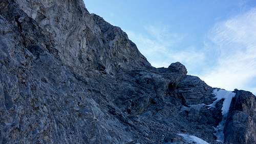
The “Golden Gully” starts between the south-west aspect at the bottom of Elpoca Tower, and the big East Face of Elpoca. More of a ramp then a gully, when snow filled, the line is obvious. When snow free, there is a bit of golden colour to the loose scree on the ramp. No trail to the bowl west of the tower, just pick a line and march to it. A creek crossing is required, but usually very easy to stay dry, follow by light trees to reach the bowl.
North Face approach
To gain the lower East Face or North Face Couloir of Elpoca Mountain, you need to head north into the ‘Piper Creek’ (unofficial name) drainage. In Piper Creek there is no official trail and two river crossings are required to gain the trail. This trail is excellent and very well trodden, it is along the eastern bank of Piper Creek and leads all the way to Piper Pass, but can be difficult to locate, but well worth the effort to find since the lower section of the valley is fairly treed and the bushwacking unpleasant. Best method to find the trail is too aim for the South Ridge of “South Tombstone” from the Elbow River trail (old road), at first through open meadows, then drop in the low Piper Creek valley, cross the creek, and just up slope, the trail parallels the creek.
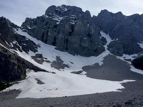
Once in the upper drainage of Piper Creek, head north towards a high col (outlier of Mt. Jerram, ‘Cat’s Ears’; and Mt. Tombstone col; Piper Pass) about 1.5 kilometre before the col, the view to the North Face of Elpoca Mountain opens up. Avalanches have created a scree field and light trees below the direct approach to the bottom of the great northern couloir making progress to the gully system easy. Several beautiful and flat bivy sites are located directly below the start of the north gully system.
When to Climb
Typical Canadian Rockies situation; best conditions for a high elevation alpine rock route is July to early September, but both known routes benefit from snow on the lower section, so June is recommended for an ascent of either route. The North Face Couloir would be less and less snow later in the summer, likely with more and more rock fall, May or June best conditions for the North Face route.
Route Descriptions
No published information, not even the “The Rocky Mountains of Canada South”, Boles, G.W., Kruszyna R. & Putnam W.L. (1979) guidebook, now out of print, has the route information to the main summit. It contains a vague description to the lower south summit (1960 by G.D. Elliot, H. Kirby, P.S. Scribens), not listed below since it does gain the summit of Elpoca Mountain.
Two trip reports (R. Collier and O. Misko) online at bivouac.com and a couple of other useful web links, links listed below.
Two routes established that ascend to the summit.
East Face Gully, South Ridge, Alpine II, 5.5
The line of the first ascent, but by persons unknown. Access to the South Ridge is up a gully/ramp on the East Face, famously named the “Golden Gully” by Orvel Miskiw. Highly recommend that if you ascend Elpoca, and this slope, do it when this slope is covered in snow, often until mid July. Other reports of ascending and descending this rock/scree slope sounds miserable. I prefer kicking steps in snow. From the basin beside Elpoca Tower, it is about 300 metres to gain the South Ridge.
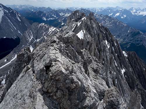
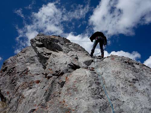
(please note, only descended this route so this beta is from that perspective). From the top of the gully/ramp the travel along the summit ridge northward is mostly 4 class scrambling or easier, accentuated with exposed, but short 5 class sections (generally 5.4/5.5). Longest and most challenging is likely the first difficulties encountered. Once atop of the “Golden Gully” on the South Ridge is only about 400 metres horizontally and about 50 veristically to main summit. First you need to descend and traverse scree ledges to the first steep section. A short 25 metre or so pitch of 5.4 leads to section of easy, but exposed ridge climbing, fourth class. Nearing the summit block, the ridge becomes more exposed. About 30 metres from the summit is the ridge crux, a downclimb to a small notch before the summit block, about 10 metres of 5.4 on thin slabby holds. Across the notch then easy 5 class to the narrow summit block.
North Face Couloir, North Ridge, Alpine IV, 5.8
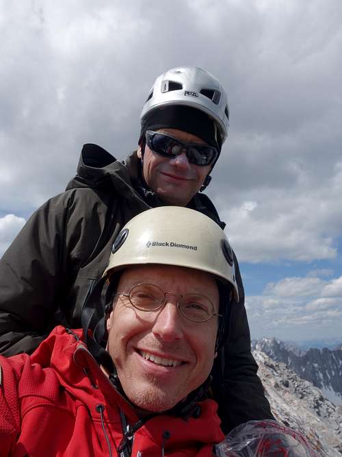
Since the summer of 2003 I have wanted to climb the great northern couloir of Elpoca Mountain. Over the intervening years, I glazed longing many times on this great feature. I had never heard of an ascent of this route, and was hoping to set a first ascent. Scott and I were successful on our climb of the couloir and North Ridge (just west below the ridge line) to the summit of Elpoca Mountain on June 26, 2017. Turns out we missed the first ascent by one year, oh well, we had an absolutely spectacular alpine day on our trip.
The Great Northern Couloir, relatively straightforward snow plod to summit ridge, but not to be taken lightly. About 350 metres of gain, slope steepest at about 50 degrees, but lots of potential for rock fall. Would recommend ascending all the snow in the dark. We started on the snow about 2am and ran out of snow, very close to North Ridge, about 4:30am. 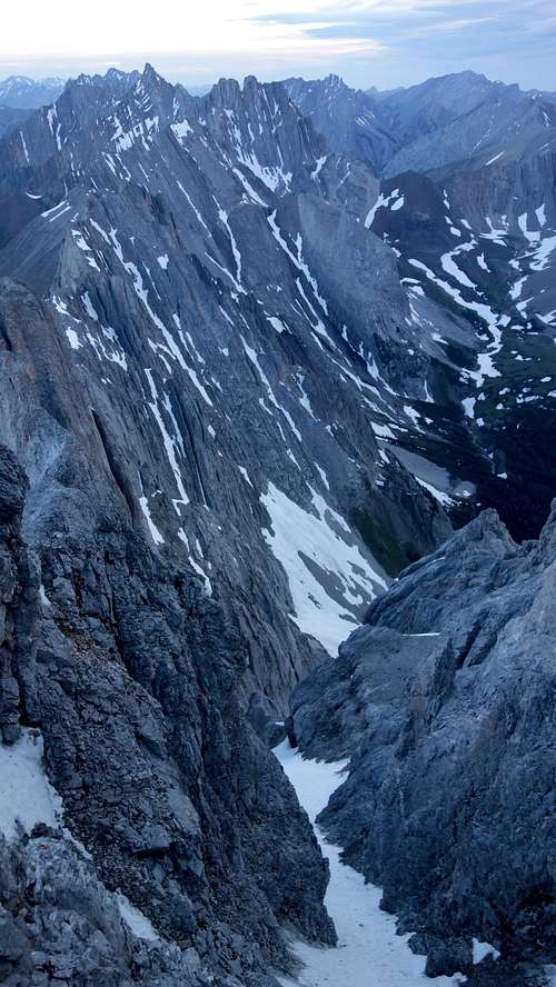
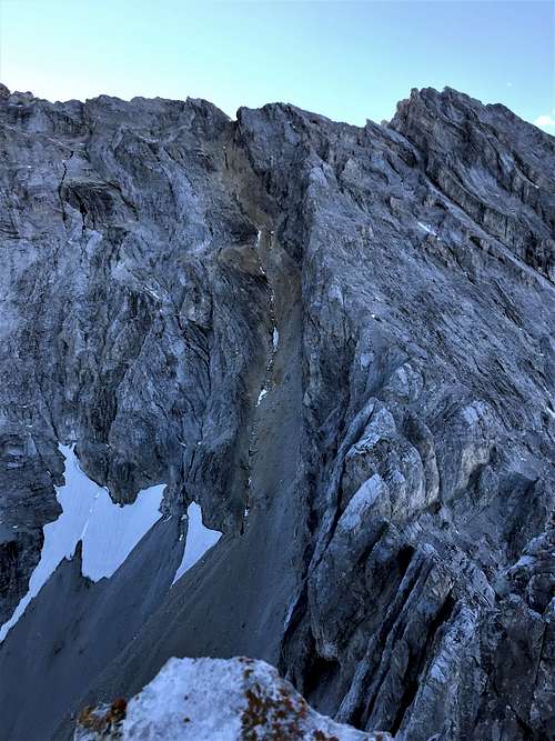
We solo’ed the snow slope, didn’t use a rope or any snow pro. We did use two technical axes and wore crampons for the ascent. Exit to our chosen low point on the ridge required some moderate mixed snow/ice/rock climbing to hit the saddle, did set a solid picket anchor to belay this pitch. About 50 metres to gain ridge. Our original plan was to gain the proper North Ridge as soon as possible, but the couloir exit had near vertical walls above and any rock exit to gain the ridge proper would be difficult, I would guess at the lowest 5.9 or even 5.10, with no easy protection. May have been easier exits part way up our mixed pitch, but no obvious line, so we gunned for the low point on the ridge.
Happy to be on the ridge and out of the serious rock fall hazard zone before the sun was fully up. We picked an easy looking line that would keep us about 70 metres below the highest ridge line we could see.
The majority of this next section was moderate terrain with a mix of scrambling loose rock, small snow slopes and a raising ascent line that would drop a bit into a gully system, then up over a rib to gain another gully edge, then repeat a few times. This travel was quick and we were unroped. Didn’t know it at the time, but we reach a traverse ledge below an overhanging wall, this ledge was directly below the summit block. This traverse ledge also had a very exposed overhanging/vertical drop beneath it. We did belay across this ledge since it was so loose and any fall would be very unforgiving. At the end of this ledge traverse was a short, but steep, rock step, our crux.
As is often the case, the rock step didn’t look that bad, but it was solid 5.8, or maybe even 5.9, on downsloping ledges with very little protection available. Scott did a fantastic lead and placed all our skinny pitons (knifeblades and bugaboos), I think about 10 pins and a few wires. About 40 metres from belay to belay. The top of the step put us very near the final section of the south summit ridge route. Above this station was another pitch of solid 5.7 climbing to gain an in place anchor station. From this station it was about 60 metres to the summit. We pitched using existing stations in place and one sling station where I left my pack. Scott did the final push up to the summit, about 5.4 downclimb on ridge (crux of south ridge route?) and about 5.4 up the short steep summit block. Apparently we have the second ascent of the Great Northern Couloir. I guess I shouldn’t have waited 15 years ;-)
We rapped off the single summit bolt. Scott ran to the fixed station, belayed me, then we returned to first fixed station we found, rap, then more downclimbing, another rap, then a bit of confusion, wasted some time finding another an easy downclimb, couldn’t but eventually found another rap station. Trying to figure when the top of the snow slope, aka the Golden Gully was a bit confusing, then we got hammered by a thunderstorm complete with hail, good times. Eventually found the top of the Golden Gully after slogging up hill to a little smooth saddle. Continued down snow slope to easy terrain.
Reference and External Links
South summit only
Boles, G.W., Kruszyna R. & Putnam W.L. (1979). The Rocky Mountains of Canada South. 7 th edition. New York: American Alpine Club, Alpine Club of Canada. Out of print
Online for North Face
Barton
http://alpinesoft.blogspot.com/2017/07/elpoca-mountain-north-couloirnorth.html
Online for East Face Gully/South Ridge
Nugara
http://anugara.net/elpoca2.htm
Song
https://stevensong.com/canadian-rockies/kananaskis/elpoca-mountain/
Collier
https://bivouac.com//TripPg.asp?TripId=212
Misko
https://bivouac.com//TripPg.asp?TripId=380