
|
|
Mountain/Rock |
|---|---|
|
|
49.08333°N / 114.13167°W |
|
|
Hiking |
|
|
Spring, Summer, Fall, Winter |
|
|
8274 ft / 2522 m |
|
|
Overview
Festubert Mountain is one of the 25 named peaks in Waterton Lakes National Park located in the province of Alberta.Much has been written about Waterton Lakes National Park in regards to climate, camping, how to get there, red tape, etc. To learn more about those things see the Mount Lineham page.
Festubert Mountain is located along the Continental Divide which forms the border between the Provinces of Alberta and British Columbia. A half kilometer, as the crow flys, from the summit lies Lone Lake basically due north.
 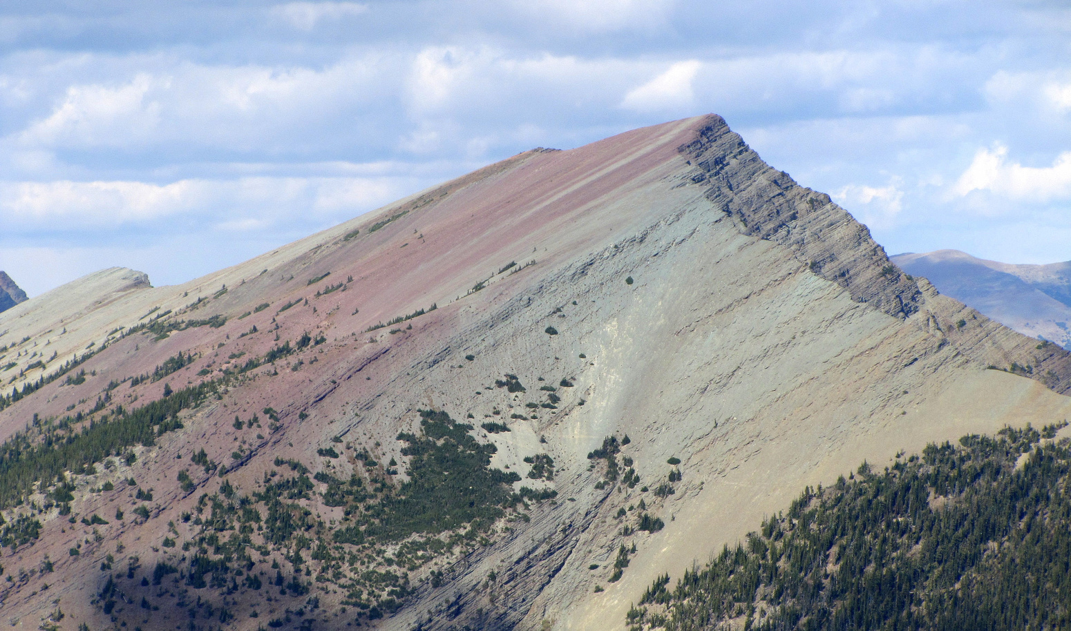 are somewhat common in Waterton Lakes National Park (Above image is displayed from Zenfolio and belongs to Calvin Damen) |
As the picture above shows, Festubert is a colorful mountain, and contains the red hues which are somewhat common in Waterton Lakes National Park. These colors can also be seen at Red Rock Canyon and Rowe Lakes, among other places.
Festubert is an out of the way peak - meaning there is no easy, or quick way to reach it. For those interested in approaching the mountain from Lone Lake, the hike to Lone Lake from Red Rock Canyon is about 8 miles one-way. Alternatively Lone Lake can be reached from the Rowe Lakes trailhead, and the Tamarack trail, after approximately 9 miles of hiking. In approaching Lone Lake from Rowe Lakes the Tamarack Trail traverses the shoulder of Festubert Mountain, and as such continuing all the way to the lake may not be necessary. If you wish to approach the mountain via its south aspect you could hike in approximately 6 miles along the Akamina Pass trail, the same trail that takes you BCs Akamina-Kishinena Provincial Park, then turn north, and follow a map and compass through the forest to the south aspect.
Andrew Nugara in his book "More Scrambles in the Canadian Rockies: 2nd Edition" suggests first climbing Mt. Rowe, then following the NW ridge between the two, an as the crow flies distance of 7 km (so probably 10 km).
This mountain gains its name from the village of Festubert in France where Canadian troops fought in WW I.
Getting There
As mentioned Festubert is located in Waterton Lakes National Park in Alberta, Canada. This Park is situated 270 km (162 miles) south of Calgary, Alberta, 43 km (27 miles) west of Cardston, Alberta, and about 80 km (48 miles) from the St. Mary entrance to Glacier National Park, Montana. When driving to Waterton Lakes National Park it can only be accessed from its eastern side.From Calgary take Highway 2 south to Fort Macleod, then west on Highway 3 to Pincher Creek, then south again on Highway 6. The drive requires about three hours.
From Cardston take Highway 5 west, through the village of Mountain View. The drive is less than 40 minutes.
From Glacier National Park, Montana, take the Chief Mountain International Highway (closed in the winter). From the St. Mary entrance of GNP it is approximately a 1 hour drive. In the winter take Montana Highway 89 to Alberta Highway 2 to Cardston, then Highway 5 to Waterton.
Once you arrive at the Park follow the entrance parkway (Highway 5) toward the town site, which is located 8 km (4.8 miles) down the road. En route, you will pass Mount Crandell, which is located directly across the highway from the famous Prince of Wales Hotel, about 1 km (0.6 miles) shy of the town. As you pass Mount Crandell, and start down the hill watch for the Akamina Parkway (aka Cameron Lake Road) on the right, as you will want to take that road. The Rowe Lakes trailhead, the typical starting point for climbing Festubert, is located 10.2 km up this narrow winding road. Prior to the Rowe Lakes trailhead is the Lineham Falls trailhead at 8.8 km up the road. Just before the Lineham Falls trailhead at 7.7 km is the Discovery Well - a National Historical site commemorating the discovery in 1902 of the first producing oil well in Western Canada.
Click here for a map.
Route
As alluded to in the Overview section there really is no defined Route or trail to the top of this mountain, and for Waterton (a very small park) this peak is out of the way.The suggested way to reach this peak, is as a side trip from the summit of Mount Rowe. The two peaks are connected by a ridge about 7 km long - with ups and downs one might figure on 10 km of walking from one peak to the other. Festubert is located NW of Rowe at a compass bearing of 307.5 degrees.
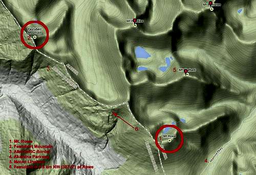
Map of Mt Rowe and Area
Alternatively one might have luck scrambling to the peak from the Lone Lake area. The Tamarack trail, en route, to Lone Lake crosses the shoulder of Festubert from which point a scramble to the summit may be possible.
Andrew Nugara in his book "More Scrambles in the Canadian Rockies: 2nd Edition" suggests descending the peak into BC and following the Akamina trail back into Waterton. As such an ascent maybe feasible from this southern aspect as well, as mentioned in the Overview section above.
Red Tape
You "gots" to pay to get into Waterton Park. Click here for the most up to date rates.Also note the park has no gas or groceries available in winter.
When to Climb
Most likely this peak would be scrambled to in the summer months of July or August, but an avid adventurer could do it anytime of the year.Camping
You will need to check with the Warden Office to obtain a permit for back country camping which may be allowed at only specified locations.Learn more at pc.gc.ca.