
|
|
Mountain/Rock |
|---|---|
|
|
49.08770°N / 114.07705°W |
|
|
Hiking |
|
|
Spring, Summer, Fall, Winter |
|
|
8839 ft / 2694 m |
|
|
Overview
Mount Hawkins is one of the many rugged, windswept peaks located within Waterton Lakes National Park in the southwestern corner of Alberta Canada. It is also a member of the Clark Range which forms part of the Continental Divide and also the boundary between the Canadian provinces of Alberta and British Columbia. A small portion of this range extends into the far northwestern section of Glacier National Park, Montana, USA. The range is named for Captain William Clark of the Lewis and Clark Expedition.Mount Hawkins is typically climbed in combination with either or both Mt. Blakiston and/or Mt. Lineham. The ridges connecting these three peaks form a horseshoe shaped cirque around the Lineham Lakes. A popular name for the hiking route that involves all three peaks is the so-called Hawkins Horseshoe shown on the terrain map below (A = Blakiston, B = Hawkin, C = Lineham). Mt. Hawkins resides on the north wall of the cirque almost at the point where the cirque wall turns to face the east.
 Hawkins Horseshoe
 The picture below is of the north side of Mt. Hawkins, as seen from Mt. Anderson. The high point to the left of center is the actual peak. Mt. Hawkins is not typically climbed from it's northside, but rather it is typcially climbed from the Akamina Parkway which runs to the east of this mountain.
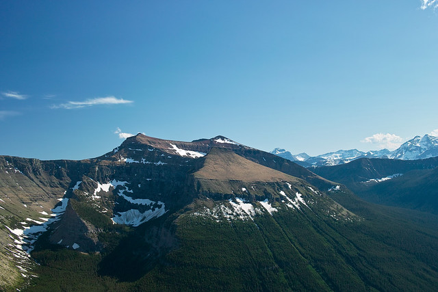  The high point to the left of center is the actual peak. Mt. Hawkins is not typically climbed from it's northside, but rather it is typcially climbed from the Akamina Parkway which runs to the east of this mountain. (Above image is displayed from Flickr and belongs to AlbertaScrambler) |
Getting There
Mount Hawkins is located in Waterton Lakes National Park in Alberta, Canada. This Park is situated 270 km (162 miles) south of Calgary, Alberta, 43 km (27 miles) west of Cardston, Alberta, and about 80 km (48 miles) from the St. Mary entrance to Glacier National Park, Montana. When driving to Waterton Lakes National Park it can only be accessed from its eastern side.From Calgary take Highway 2 south to Fort Macleod, then west on Highway 3 to Pincher Creek, then south again on Highway 6. The drive requires about three hours.
From Cardston take Highway 5 west, through the village of Mountain View. The drive is less than 40 minutes.
From Glacier National Park, Montana, take the Chief Mountain International Highway (closed in the winter). From the St. Mary entrance of GNP it is approximately a 1 hour drive. In the winter take Montana Highway 89 to Alberta Highway 2 to Cardston, then Highway 5 to Waterton.
Once you arrive at the Park follow the entrance parkway (Highway 5) toward the town site, which is located 8 km (4.8 miles) down the road. En route, you will pass Mount Crandell, which is located directly across the highway from the famous Prince of Wales Hotel, about 1 km (0.6 miles) shy of the town. As you pass Mount Crandell, and start down the hill watch for the Akamina Parkway (aka Cameron Lake Road) on the right, as you will want to take that road. The Lineham trailhead, the typical starting point for climbing Mount Hawkins (when climbing it along with Mt. Blakiston), is located 5.5 miles (8.8 km) up this narrow winding road. Just prior to the Lineham trailhead at 4.8 miles (7.7 km) is the Discovery Well - a National Historical site commemorating the discovery in 1902 of the first producing oil well in Western Canada. Less than a mile (about 1.4 km) further up the road from the Lineham trailhead is the Rowe Lakes trailhead a potential exit point for those doing the Hawkins Horseshoe of Mount Blakiston, Mt. Hawkins and Mt Lineham. If climbing only Mt. Hawkins, or Mt. Linehham and Mt. Hawkins together the logical starting point is also the Rowe Lakes trailhead.
Click here for a map.
Routes
Mt. Hawkins is typically climbed along with one or both of its neighbors, as such for routes information please refer to Mt. Blakiston or Mt. LinehamCamping
Camping is not allowed on Mount Hawkins, however there are 9 wilderness campsites in Waterton. You should contact the park to make reservations for wilderness campsites.Additionally Parks Canada operates four campgrounds in Waterton Lakes National Park. Click here for details.
History
Similiar to other peaks in the Wateron Lakes area Mt. Hawkins is named after a member of the Boundary Commission. The Boundary Commission was an instrument of both Great Britain and the USA set up in the mid-1800s to determine exactly where the 49th parallel was. The 49th parallel forms part of the Canada/USA border from British Columbia to Manitoba on the Canadian side and from Washington to Minnesota on the U.S. side aka from the Strait of Georgia to the Lake of the Woods.Between 1858 and 1862 the Columbia Detachment of the Boundary Commission was headed by Lt Colonel John Summerfield-Hawkins for whom Mt. Hawkins is named.

(Above image is displayed from and belongs to royalengineers.ca)
Of the nearly 1,500 mountain peaks of the Canadian Rockies, more than 600 are named after a person considered worthy of the honour. The names chosen reflect who, as well as what, was important to those naming the peaks and in many cases what was relevant and important to Canadian society in general.
Weather
The summers in the Mount Hawkins area are brief with some hot spells (high 35*C/94*F). Winters are long and relatively mild (high 10*C/50*F), with occasional warm spells caused by Chinook winds. This area is often one of Alberta's warmest places in the winter, despite ample snow and temperatures that can occasionally drop as low as -40*C/-40*F.Wind is a noticeable element of this area’s climate, and shouldn’t be ignored. Gusts of over 100 km/hr (60 mph) are common, but thankfully they occur mostly in the fall and winter rather than the summer. Note that gusts of over 150 km/hr (90 mph) have frequently been recorded in the area.
This area receives Alberta 's highest average annual precipitation of 1072 mm (42 inches) per year.
Red Tape
In the spring, summer, and fall, one must pay an entrance fee in order to get into Waterton Lakes Park, home of Mount Blakiston. There is no fee in the winter. As of summer, 2011 the Canadian dollar daily rates were $7.80 per adult or $19.60 for a family/group. Click here for the most up to date rates.Also note the park has no gas or groceries available in winter.
When traveling to Waterton Lakes National Park from Glacier National Park in the US state of Montana one must be aware of the Canada Ports of Entry operating schedules. Chief Mountain port of entry is open seasonally (closed in Winter) from May through September and Carway/Peigan port of entry is open year round from 7:00 a.m. to 11:00 p.m.
Panoramic View
Panoramic View From Nearby Mount Crandell, with Mount Hawkins labeled on the far right (you will need to use the horizontal scroll bar below to see the label for Mount Hawkins).The image below is displayed from and belongs to explor8ion.com
More photos of this peak can be seen here.